According to the Manitoba Historical Society, the Volunteer Monument was unveiled at Winnipeg's Old City Hall on September 28, 1886. The monument commemorated the soldiers of 90th Winnipeg Rifles (also known as the "Little Black Devils") who were killed during the 1885 North West Rebellion. In 1968, the monument was moved to the east side of Main Street, between the Centennial Concert Hall and the Manitoba Museum.
Scope and Content
Photograph shows a parade marching south along Main Street in front of the Volunteer Monument on Winnipeg's Old City Hall grounds (1886-1962). The parade was in honour of Queen Victoria's Diamond Jubilee that was held June 22, 1899. Businesses visible on the west (left) side of Main Street include: the Great Northern Railway Line, Gurney Stove & Range Co., Sherman House, The Arlington Hotel, Hurtley & Co., Central Drug Hall, Inman Optical Co. On the east side of Main Street, the Conferation Life Block is draped with bunting and a large ensign flag is flying from its tower. Specators line the streets and can be seen on roof tops and leaning from windows.
Notes
The front of the photograph reads: Jublee [sic.] Procession June 22/99 Winnipeg
Postcard is bent, inked stained, and has emulsion artifacts
Scope and Content
Photograph shows a wood-framed bungalow with ornamental woodwork on the porch and roof. The home has a wooden picket fence. A woman and child are seated on one side of the ballustrade and a woman in an overcoat and hat is seated on either side of the ballustrade. Neighbouring homes are also visible.
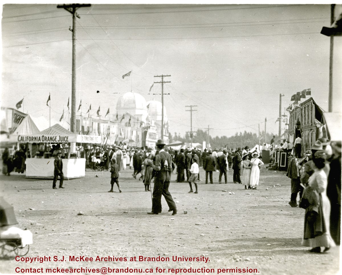
Photograph shows the midway at the 1913 Dominion Fair. Attractions include California Orange Juice stand and Patterson's Animal Trainer Show. The Dominion Exhibition Display Building II can be seen in the background.
Notes
Photograph appears to be a part of a sequence of photographs, see 20-2009.30 to 20-2009.40
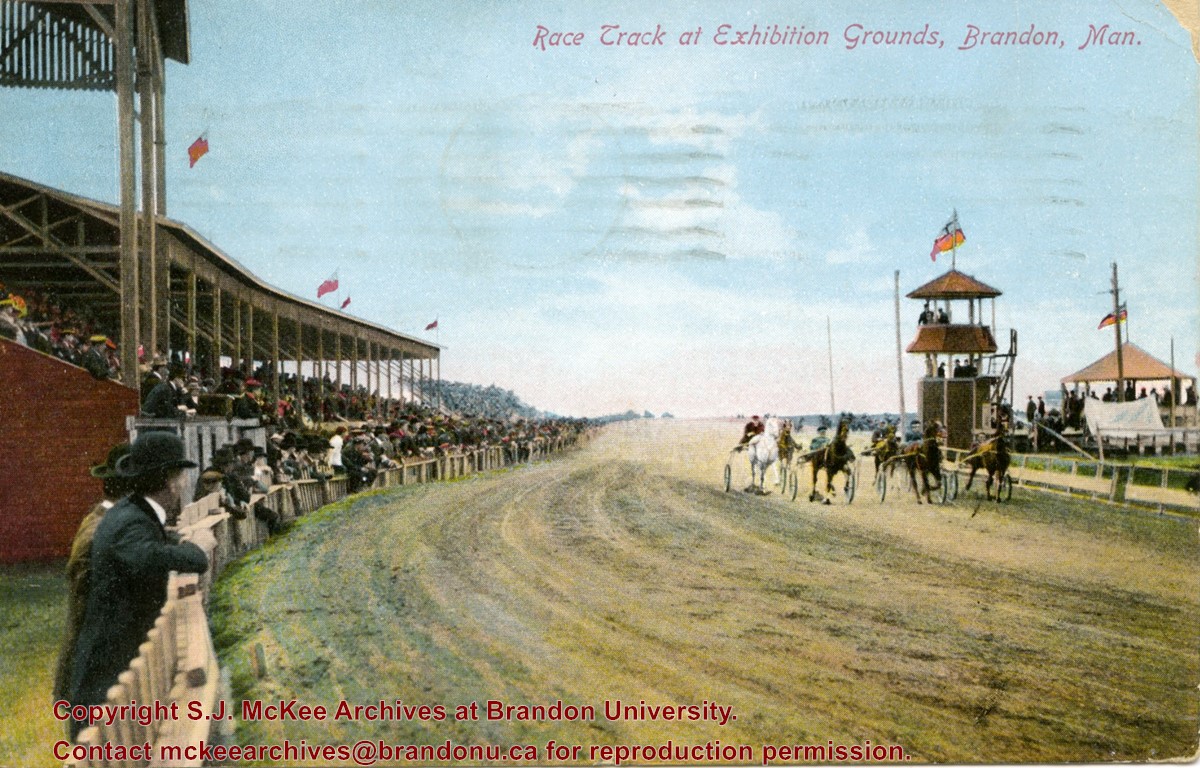
Postcard shows the grandstand and race track located at the Exhibition Grounds (now the site of the Keystone Centre/Westman Communications Place) in the south end of Brandon, Manitoba. The bleachers are filled with people and spectators also line the fence alongside the track. Five harness racers are making their way along the track. An observation tower and possible gazebo for dignitaries is located inside the track.
Notes
The back of the postcard is address to Mrs. Sharpe of Banff, Alberta. A green King George One Cent stamp has been postmarked Sault Ste. Maire, Ont., July 6, 1910. The message reads: Lake Superior, My dear. How are you? Glad you are charmed with B. don't get too fat. Tell Mrs. Coates my state room companion is Miss Rutherford of B. Coll: she got on at Port Arthur. Having a lovely trip. It was hard parting at B. .......Address 14 Deer Park, Toronto. Postcard manufactured by Stedman Bros. Ltd., Brantford, Canada. S.B. 2376. Made in Germany.
According to Russ Gourluck (Silver Screens on the Prairie, Winnipeg: Great Plains Publications, 2012, 26), the Orpheum Theatre was in operation from 1917 to 1920 when it then became the Willis Theatre.
Scope and Content
Postcard shows the 100 block of 10th Street facing north. The CPR train station can be seen at the end of 10th Street. The sign for the Rex Cafe is visible on the west side of 10th Street. On the east side of 10th Street, billboards for Campbell & Campbell furniture are visible as well as signs for Pianos and the Orpheum Theatre. Motorists and cyclists share the road. Street car tracks run the length of 10th Street.
Notes
Postcard was manufactured by T.B. [Tichnor Brothers, Inc., 1908-1987] Cambridge, Massachusetts.
Left hand corner of mat is bent. Mock-up instructions are written in pencil at the bottom right hand corner. Portions of the photograph itself are marked with pen.
History / Biographical
The Queen's Hotel was located on the corner of Rosser Avenue and Tenth Street (Steen & Boyce, 1882. Brandon, Manitoba, Canada and Her Industries. Steen & Boyce Publishers Printers & Binders, 81.). Therefore this photo appears to display Rosser Avenue looking east. P.E. 11/06/09
Scope and Content
Photograph shows early Rosser Avenue under construction between 9th Street and 10th Street in the 1880s. Buildings that line the avenue are wood framed and there are wooden boardwalks in front of a few structures. On the north side of Rosser Avenue signs for Fortier & Bucke Commision Agents and Transit House (Hotel) can be seen. On the south side of Rosser Avenue, the Queen's Hotel and Robinson Brothers and Company groceries and dry goods store are open for business. A family appears to be standing on the stoop at the dry goods store. A boy is lounging in the entryway of the Queen's Hotel. A man is standing on a wooden plank that extends across the dirt road of Rosser Avenue between the dry goods store and the commission agents' shop.
These records were produced between 1984 and 1985, the researching and writing period for the book The Pride of the Land: An Affectionate History of Brandon’s Agricultural Exhibition. Published in 1985 by Peguis Books (Winnipeg), Pride of the Land is a 222-page soft cover book, containing hundreds of pictures, and 50,000 words of text.
BU faculty members Dr. Kenneth “Ken” Stephen Coates, Assistant Professor of History, and Mr. Fred McGuinness, Lecturer in Journalism, authored the book. Assisting the writers was a research team of four BU history students, which were referred to as “The Pride Team”: Diane Fowler, Rob McGarva, Bruce Stafeld, and Byron Williams.
The Pride Team was tasked with collecting and synthesizing exhibition documents and other materials in city, provincial, and federal records spanning 100 years. Many local newspapers and committee minutes were consulted.
The authors cover 103 years of Brandon Fair history, starting with the first fair in 1882 followed by the development of other agricultural fairs and exhibitions in Brandon, specifically The Royal Manitoba Winter Fair, The Provincial Exhibition of Manitoba, and the Ag-Ex livestock show.
Custodial History
Records were collected and created by McGuinness, Coates, and The Pride Research Team during the process of the creation of the book, The Pride of the Land: An Affectionate History of Brandon’s Agricultural Exhibition. The materials were donated to the SJ McKee Archives by the authors circa 1988. The Archives accessioned the records in 2008.
Scope and Content
The subseries consists of textual records, created and collected during the production of the monograph Pride of the Land. It includes research cards created by the research team, copies of newspaper articles from very early editions of Brandon newspapers (such as the Brandon Sun, Brandon Daily Sun, Western Sun, and The Independent), copies of fair/organizational minutes, photocopies of photographs used in the publication, and chapter drafts. Of particular interest are the detailed summaries of Provincial Exhibition minutes that were specifically produced for each book chapter.
Notes
Information in the history/biography was taken from a Brandon University press release dated June 1985, about the Pride of the Land Project (see file 64)
Description Note: The original accession number is noted on the front of each file folder. The circled number indicates the original file order in the 6-2008 accession
Accruals
Closed
Language Note
Fred McGuinness often uses journalistic jargon to label his files. A “brite” refers to a short, amusing story
Pride of the Land acronyms:
PEM = Provincial Exhibition Association of Manitoba
RCMP = Royal Canadian Mounted Police
WAAA = Western Agricultural & Arts Association
Finding Aid
A file level inventory is available
Storage Location
2015 accessions
Related Material
Provincial Exhibition Association of Manitoba fonds
Arrangement
Arrangement was artificially created by the Archives. Subseries has been arranged according to book chapter. McGuinness often organized his ideas and research materials by potential brite topic
Photograph shows the 700-block of Rosser Avenue facing west. Visible businesses on the north side of Rosser Avenue include: Burchill's Music Store, E.W. Woolworth Co. Ltd. 5-10 and 15 Cent Store in the E.E. Evans Block, Empire Hotel, and W.A. Paterson Drugs. Automobiles are parked on both sides of the avenue and at the time the photograph was taken, Rosser Avenue was a two-way street.
Notes
Part of "Souvenir of Brandon, Manitoba, Canada [viewbook], Printed by Photogelatine Engraving Co. Limited, Ottawa." Dates obtained from the Burchill's Music Store Henderson's Brandon City Directory listings (1927-1929). Writing on the front of the photograph reads: Rosser St. [sic.] - Brandon, Man.
Photograph shows the exterior of the Winter Fair Arena on 10th Street.
Notes
Part of "Souvenir of Brandon, Manitoba, Canada [viewbook], Printed by Photogelatine Engraving Co. Limited, Ottawa." Dates obtained from the Burchill's Music Store Henderson's Brandon City Directory listings (1927-1929). Writing on the front of the photograph reads: Winter Fair Arena, Brandon, Man.
Photographs have been glued to a backing board that has warped over time
Custodial History
On 16 November 1906, Manitoba was hit by a severe winter storm that began that Thursday evening and extended through the weekend. The Brandon Daily Sun ("Storm Extends Over a Large Territory," 17 Nov. 1906, 1) reported that rail and telegraph services had been disrupted, country roads were impassable, and business in town was at a stand still. Following the weekend, the daily reported the blizzard was one of the greatest in recent memory. CPR trains had been caught in drifts by Carberry and an express car had caught fire and was destroyed ("Worst Storm in Many Years," Brandon Daily Sun, 19 Nov. 1906, 1).
Scope and Content
Photograph shows street view of north side of Rosser Avenue, primarily the 700 block. The Fleming Block, Beaubier Block and its Empire Hotel, A.M. Percival (a grocer), the Brandon Hardware Company (600 block), and the Arlington Hotel (500 block) are visible along the north side of the avenue. The Bank of Hamilton Building on the southeast corner of 8th Street and Rosser appears to be under construction. The streets are muddy and a horse and buggy is traveling west on Rosser Avenue.
Notes
Writing on the front of the photograph matting reads: during the great storm of November 16 1906, 341. The photograph appears to be taken from the interior of a builing on the southwest corner of 7th Street and Rosser Avenue. Page appears to be from a photo album.
Photograph shows a street view of 10th Street facing north. There are many automobiles parked along the street and several pedestrians in summer dress are on the sidewalks and street. Visible business signs include: Hentzman & Co. Pianos (possibly belonging to J.J.H. McLean Co. Ltd.), the Strand Theatre, T & D Clothes, Campbell & Campbell, the CPR Station, and Bowling Alley and Billiards.
Notes
Part of "Souvenir of Brandon, Manitoba, Canada [viewbook], Printed by Photogelatine Engraving Co. Limited, Ottawa." Dates obtained from the Burchill's Music Store Henderson's Brandon City Directory listings (1927-1929). Writing on the front of the photograph reads: 10th St., looking north (C.P.R. Station at end of Street) Brandon, Man.
Photograph shows the CPR Train Station on Pacific Avenue and 10th Street.
Notes
Part of "Souvenir of Brandon, Manitoba, Canada [viewbook], Printed by Photogelatine Engraving Co. Limited, Ottawa." Dates obtained from the Burchill's Music Store Henderson's Brandon City Directory listings (1927-1929). Writing on the front of the photograph reads: CPR Station, Brandon, Man.
Photograph shows a southwest view of the Prince Edward Hotel and train station.
Notes
Part of "Souvenir of Brandon, Manitoba, Canada [viewbook], Printed by Photogelatine Engraving Co. Limited, Ottawa." Dates obtained from the Burchill's Music Store Henderson's Brandon City Directory listings (1927-1929). Writing on the front of the photograph reads: Prince Edward Hotel, Brandon, Man.
Photographs have been glued to a backing board that has warped over time
Scope and Content
Photograph shows street view of north side of Rosser Avenue, primarily the 700 block, along which sewer pipe is being laid. Visible buildings and businesses include: The Fleming Block with Lowes Brothers Clothing and Manitoba Farmers Hedge and Wire Fence Company, the Beaubier Block and its Empire Hotel, A.M. Percival (a grocer), the Brandon Hardware Company (600 block), and the Arlington Hotel (500 block) are visible along the north side of the avenue. The Bank of Hamilton Building is on the southeast corner of 8th Street and Rosser Avenue.
Notes
Writing on the front of the photograph matting reads: 290. Page appears to be from a photo album.
Photograph shows a panorama, bird's-eye-view of downtown Brandon, between Pacific and Rosser Avenues and 7th Street facing east. Photoraph likely taken from the McKenzie Seeds Building. Visible businesses include: Western Canada Flour Mills, Hanbury Hardware Co. Ltd., Cockshutt Plow Co., New Pacific Hotel, Gordon McKay Building, and Arlington Hotel.
Notes
Part of "Souvenir of Brandon, Manitoba, Canada [viewbook], Printed by Photogelatine Engraving Co. Limited, Ottawa." Dates obtained from the Burchill's Music Store Henderson's Brandon City Directory listings (1927-1929). Writing on the front of the photograph reads: Panorama of Brandon, Man.
Photographs have been glued to a backing board that has warped over time
History / Biographical
Photograph of possible Dakota from Sioux Valley in Brandon for the summer fair.
Scope and Content
Photograph shows street view of north side of Rosser Avenue, primarily the 700 block. Businesses visible in the Fleming Block include: Lowes Brothers Clothing, Robert Hall [Insurance Broker], Manitoba Farmers Hedge and Wire Fence Company. Businesses visible in the Beaubier Block include the Empire Hotel. Businesses east of the Empire Hotel are grocer A.M. Percival and the Brandon Hardware Company. A number of Aboriginal peoples are travelling on horseback west along Rosser Avenue as spectators look on.
Notes
Writing on the front of the photograph matting reads: 293. One photograph (20-2009.9) is glued above and two others are glued on the reverse side. Page appears to be from a photo album.
Photographs have been glued to a backing board that has warped over time
History / Biographical
Photograph of possible Dakota from Sioux Valley in Brandon for the summer fair.
Scope and Content
Photograph shows street view of north side of Rosser Avenue, primarily the 700 block. Businesses visible in the Beaubier Block include the Empire Hotel. Businesses east of the Empire Hotel are grocer A.M. Percival, the Brandon Hardware Company, and the Arlington Hotel. A number of Aboriginal peoples are driving horse and buggies east along Rosser Avenue as large numbers of spectators look on.
Notes
Writing on the front of the photograph matting reads: 298. One photograph (20-2009.79) is glued above, another (20-2009.81) adjacent. One other is glued on the reverse side. Page appears to be from a photo album.
Photographs have been glued to a backing board that has warped over time
History / Biographical
Photograph of possible Dakota from Sioux Valley in Brandon for the summer fair.
Scope and Content
Photograph shows street view of north side of Rosser Avenue, primarily the 700 block. Businesses visible in the Fleming Block include: Lowes Brothers Clothing, Robert Hall [Insurance Broker], Manitoba Farmers Hedge and Wire Fence Company. Businesses visible in the Beaubier Block include the Empire Hotel. Businesses east of the Empire Hotel are grocer A.M. Percival and the Brandon Hardware Company. A number of Aboriginal peoples are driving horse and carriages west along Rosser Avenue as spectators look on.
Notes
Writing on the front of the photograph matting reads: 295 July 1906. One photograph (20-2009.11) is glued above and two others are glued on the reverse side. Page appears to be from a photo album.
Photographs have been glued to a backing board that has warped over time
Scope and Content
Photograph shows street view of north side of Rosser Avenue, primarily the 700 block. The Fleming Block, Beaubier Block and its Empire Hotel, A.M. Percival (a grocer), the Brandon Hardware Company (600 block), and the Arlington Hotel (500 block) are visible along the north side of the avenue. The Bank of Hamilton Building on the southeast corner of 8th Street and Rosser appears to be under construction. A sign in the second storey window above the main entrance reads: law office. The streets are muddy and a horse and buggy is traveling west on Rosser Avenue.
Notes
Writing on the front of the photograph matting reads: mud November 12, 1906, 339. The photograph appears to be taken from the interior of a builing on the southwest corner of 8th Street and Rosser Avenue. Page appears to be from a photo album.


