[The land on which city hall stood in this photo is now known as Princess Park. P.E. 01/06/09]
Custodial History
For custodial history see the collection level description of the Lawrence Stuckey collection.
Scope and Content
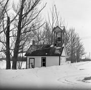
Princess Avenue, showing City Hall & CKX radio tower
Notes
[View is from 9th Street looking east. P.E.]
"Radio towers of CKX on city hall grounds were 150 feet tall; Studio and transmitter were on the east side of city hall." - Fred McGuinness collection (20-2009).
For custodial history see the collection level description of the Lawrence Stuckey collection.
Scope and Content
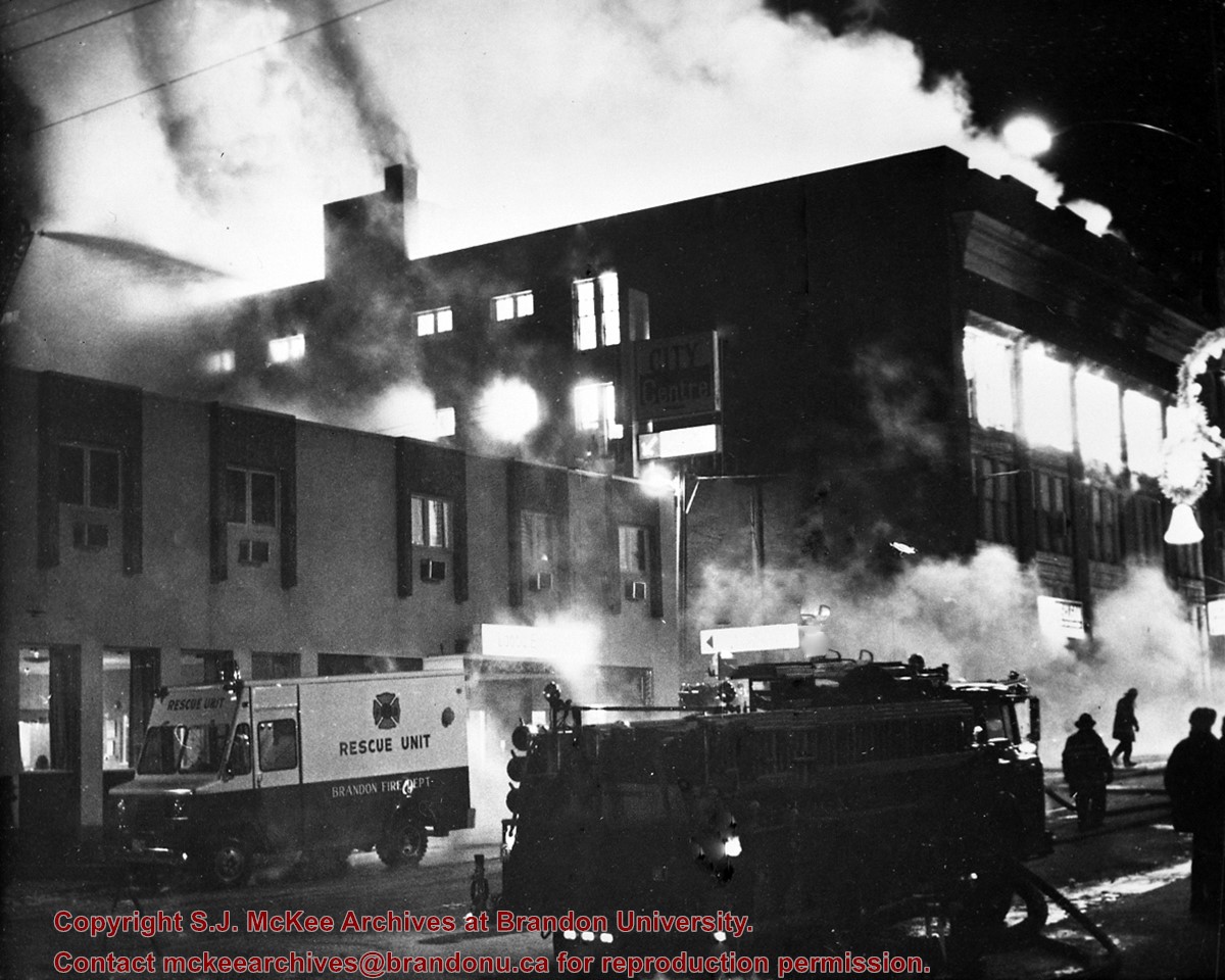
Christie Building Fire
Notes
Located on the south side of the 800 block Rosser Ave.
Building was empty at the time and prepared for demolition for the new Gallery Mall. The fire was believed to be started by vandals, probably accidentally.
This photo also shows the Brandon Fire Department's (then) newest fire engine (see also file F21).
For custodial history see the collection level description of the Lawrence Stuckey collection.
Scope and Content
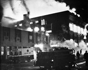
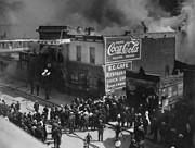
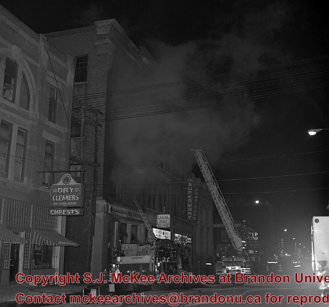
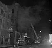
Stylerite Hardware building fire
Notes
Formerly Brandon Hardware.
[Mr. Stuckey put four negatives in same envelope, numbered FA10 and FA10a. We have separated them and numbered them FA10(1) and FA10(2), and FA10a(1) and FA10a(2).]
For custodial history see the collection level description of the Lawrence Stuckey collection.
Scope and Content
Stylerite Hardware building fire
Notes
Formerly Brandon Hardware.
[Mr. Stuckey put four negatives in same envelope, numbered FA10 and FA10a. We have separated them and numbered them FA10(1) and FA10(2), and FA10a(1) and FA10a(2).]
Photographs have been glued to a backing board that has warped over time
History / Biographical
Photograph of possible Dakota from Sioux Valley in Brandon for the summer fair.
Scope and Content
Photograph shows street view of north side of Rosser Avenue, primarily the 700 block. Businesses visible in the Fleming Block include: Lowes Brothers Clothing, Robert Hall [Insurance Broker], Manitoba Farmers Hedge and Wire Fence Company. Businesses visible in the Beaubier Block include the Empire Hotel. Businesses east of the Empire Hotel are grocer A.M. Percival and the Brandon Hardware Company. A number of Aboriginal peoples are driving horse and carriages west along Rosser Avenue as spectators look on.
Notes
Writing on the front of the photograph matting reads: 295 July 1906. One photograph (20-2009.11) is glued above and two others are glued on the reverse side. Page appears to be from a photo album.
Photographs have been glued to a backing board that has warped over time
Scope and Content
Photograph shows street view of north side of Rosser Avenue, primarily the 700 block. The Fleming Block, Beaubier Block and its Empire Hotel, A.M. Percival (a grocer), the Brandon Hardware Company (600 block), and the Arlington Hotel (500 block) are visible along the north side of the avenue. The Bank of Hamilton Building on the southeast corner of 8th Street and Rosser appears to be under construction. A sign in the second storey window above the main entrance reads: law office. The streets are muddy and a horse and buggy is traveling west on Rosser Avenue.
Notes
Writing on the front of the photograph matting reads: mud November 12, 1906, 339. The photograph appears to be taken from the interior of a builing on the southwest corner of 8th Street and Rosser Avenue. Page appears to be from a photo album.
For custodial history see the collection level description of the Lawrence Stuckey collection.
Scope and Content
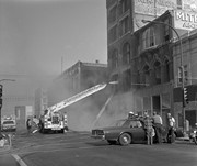
Stylerite Hardware - immediate demolition of building's shell after fire
Notes
Formerly Brandon Hardware.
[Mr. Stuckey put four negatives in same envelope, numbered FA10 and FA10a. We have separated them and numbered them FA10(1) and FA10(2), and FA10a(1) and FA10a(2).]
For custodial history see the collection level description of the Lawrence Stuckey collection.
Scope and Content
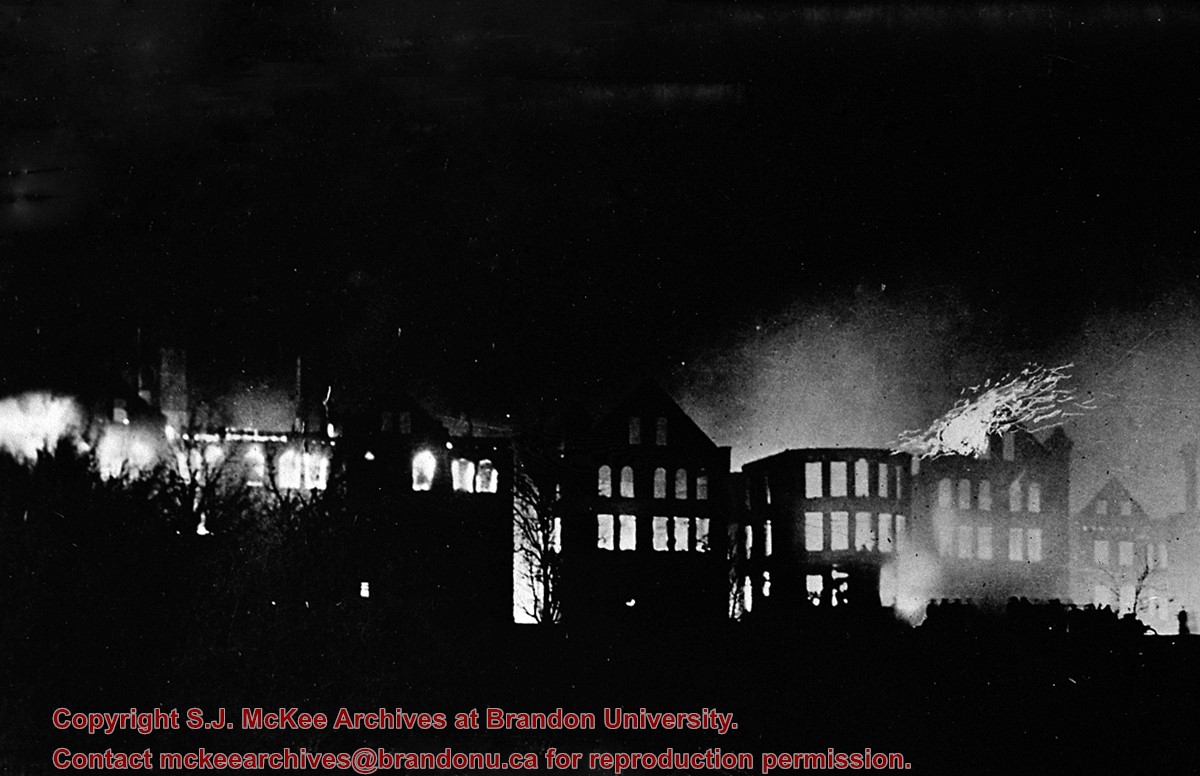
The Brandon Asylum for the Insane
Notes
The entire Brandon Asylum complex was completely destroyed. Patients were temporarily housed in the Winter Fair Building (located on the 500 block of 10th Street).
It is reported that the nearly 700 staff and patients were evacuated without any loss of life due to the fire itself (Refvik K. 1991. The Brandon Asylum Fire of 1910. Manitoba History, Number 21, Spring 1991).
Mr. Stuckey's notes: Copy [of a] neg[ative]. Neg[ative] in collection, Dick George.
Custodial History
For custodial history see the collection level description of the Lawrence Stuckey collection.
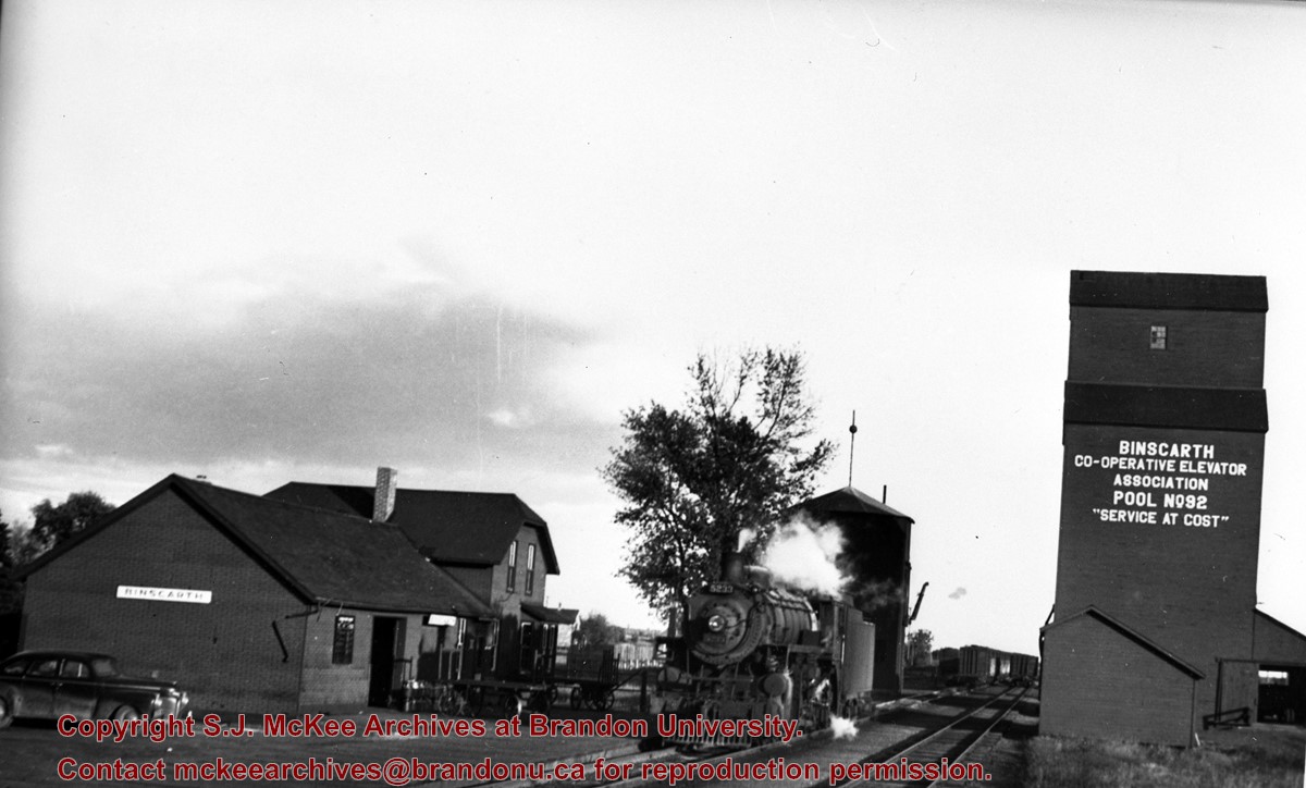
Scope and Content
Image of CP 5233, station, water tank, and elevator. Binscarth, Manitoba. Image was taken along the CPR Minnedosa & Bredenbury subdivision (ex. Manitoba & N.W. Railway).
Notes
[Image shows a Binscarth Co-operative Elevator Association elevator].
For custodial history see the collection level description of the Lawrence Stuckey collection.
Scope and Content
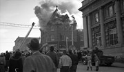
John E. Smith Block Fire
Notes
The John E. Smith Block was built in 1907.
Because of the fire, the building was badly gutted and the front wall bulged outward. As a result, the structure was condemned.
The Canadian Bank of Commerce had moved to the Canadian Imperial Bank of Commerce building at the corner of 8th Street & Rosser Avenue in mid-1960's, and their old building adjacent to Smith Block had since sat vacant. As a result, the stage was now set to clear the area where both buildings had stood for the construction of Scotia Tower. LAS.
[Mr. Stuckey put two negatives in same envelope, numbering them FA7 and FA7a. We have separated them.]
Photographs have been glued to a backing board that has warped over time
History / Biographical
Photograph of possible Dakota from Sioux Valley in Brandon for the summer fair.
Scope and Content
Photograph shows street view of north side of Rosser Avenue, primarily the 700 block. Businesses visible in the Fleming Block include: Lowes Brothers Clothing, Robert Hall [Insurance Broker], Manitoba Farmers Hedge and Wire Fence Company. Businesses visible in the Beaubier Block include the Empire Hotel. Businesses east of the Empire Hotel are grocer A.M. Percival and the Brandon Hardware Company. A number of Aboriginal peoples are driving horse and buggies west along Rosser Avenue as spectators look on.
Notes
Writing on the front of the photograph matting reads: 294 July 1906. One photograph (20-2009.10) is glued below and two others are glued on the reverse side. Page appears to be from a photo album.


.jpg?width=1200&404=no-img.jpg&watermark=wmk)
.jpg?width=180&404=no-img.jpg)
.jpg?width=1200&404=no-img.jpg&watermark=wmk)
.jpg?width=180&404=no-img.jpg)
.jpg?width=1200&404=no-img.jpg&watermark=wmk)
.jpg?width=180&404=no-img.jpg)
.jpg?width=1200&404=no-img.jpg&watermark=wmk)
.jpg?width=180&404=no-img.jpg)


.jpg?width=1200&404=no-img.jpg&watermark=wmk)
.jpg?width=180&404=no-img.jpg)
.jpg?width=1200&404=no-img.jpg&watermark=wmk)
.jpg?width=180&404=no-img.jpg)


.jpg?width=1200&404=no-img.jpg&watermark=wmk)
.jpg?width=180&404=no-img.jpg)
.jpg%3fmaxheight%3d1000%26maxwidth%3d1000%26watermark%3dwmk&description=Stylerite+Hardware+Fire)
.jpg%3fmaxheight%3d1000%26maxwidth%3d1000%26watermark%3dwmk&description=Stylerite+Hardware+Fire)
.jpg%3fmaxheight%3d1000%26maxwidth%3d1000%26watermark%3dwmk&description=McDiarmid+%26+Clark+Fire)
.jpg%3fmaxheight%3d1000%26maxwidth%3d1000%26watermark%3dwmk&description=McDiarmid+%26+Clark+Fire)
.jpg%3fmaxheight%3d1000%26maxwidth%3d1000%26watermark%3dwmk&description=Stylerite+Hardware+Fire+-+Demolition)
.jpg%3fmaxheight%3d1000%26maxwidth%3d1000%26watermark%3dwmk&description=Stylerite+Hardware+Fire+-+Demolition)
.jpg%3fmaxheight%3d1000%26maxwidth%3d1000%26watermark%3dwmk&description=Central+United+Church+-+After+Fire)