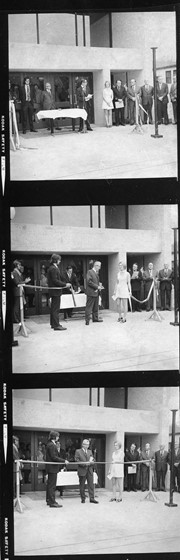
Item is three contact prints taken at the opening of McMaster Hall.
Print 1 (L toR): ?, Murray(?) Simmons, Lloyd Dulmage (Microphone); ?, Walter Dinsdale (M.P.), Bill Wilton (Mayor), Scott Bateman (Chairman of University Grants Commission), ?, ?
Print 2 (L to R): Lyle Dick (?), holding ribbon (?), Lloyd Dulmage, Murray(?) Simmons, (?) holding ribbon, Walter Dinsdale, Bill Wilton, Scott Bateman
Print 3 (L to R): Lyle Dick (?), ?, Lloyd Dulmage, Murray(?) Simmons, ?, Walter Dinsdale, Bil Wilton, Scott Bateman
Photograph shows L to R: Gordon MacPherson (Dean of Music), Robert Clement (Lawyer, Smart Estate), and President John Mallea at the entrance of the QEII Music Building.
See sub sub series level (RG 6, 8.4.1) for history/bio information.
Custodial History
See sub sub series level (RG 6, 8.4.1) for custodial history.
Scope and Content
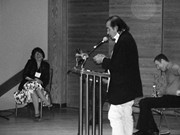
Photograph of Tomson Highway at the Welcome and Opening Ceremonies held on October 25 in the Lorne Watson Recital Hall. Lorraine Mayer is seated on the left, Gregory Scofield is seated on the right.
Storage Location
RG 6 Brandon University fonds
Series 8: Library Services
8.4 Library special events
8.4.1 Brandon Aboriginal Literary Festival
See sub sub series level (RG 6, 8.4.1) for history/bio information.
Custodial History
See sub sub series level (RG 6, 8.4.1) for custodial history.
Scope and Content
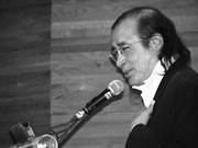
Photograph of Maria Campbell giving a reading at the Welcome and Opening Ceremonies held on October 25 in the Lorne Watson Recital Hall. Lorraine Mayer in the background.
Storage Location
RG 6 Brandon University fonds
Series 8: Library Services
8.4 Library special events
8.4.1 Brandon Aboriginal Literary Festival
Photograph was taken at the Jeff Umphrey Memorial Centre Grand Opening. L-R: Dr. Ho, Ewart Murray?, ?, Mrs. R.A. (Mary) Clement(?), Mrs. Hilda Umphrey, ?, ?, Dr. A.L. Dulmage (Brandon University President), W.C. Burgess (Board of Governors), Damien Roy.
Mrs. Hilda Umphrey cuts the ribbon at the Jeff Umphrey Memorial Centre Grand Opening. L to R: Dr. Ho, ?, -- Murray?, ?, ?, Mrs. Umphrey, ?, W.C. Burgess (Board of Governors), A.L. Dulmage (Brandon University President), Damien Roy, ?.
The Medicine Hat Exhibition and Stampede Parade Day was held on Thursday, July 19, 1962, at 9:30 a.m. The local newspaper reported that approximately 24,000 people were in attendance to see parade marshall Rod Ashburner leading 175 entries consisting of 90 floats, 75 horses, and 10 bands. There were 19 parade categories eligible for $12,000 in prize money and included: junior and senior cowboys and cowgirls; fancy and Shetland ponies; sulky class open; comic, commercial, industrial and organizational floats; decorated cars; special ranch class; 4-H Clubs; and a non-competitive class.
The parade route started at Second St. and Allowance Ave., from Second St. to Ash Ave., north on Ash to First St. SE., from First St. S.E. to Fourth Ave., south to Second St. to South Railway St., south on South Railway St. to Third St., with a finish at McLeod Trail. A route map was published in the Medicine Hat News the day before the parade.
Aerial photographs of the parade were taken by Medicine Hat News photographer Howard Heid (1930-2005) from the private helicopter of John Bourn. Bourn was a pilot from Woodville, Wisconsin, who chartered his four-seater helicopter for sight-seers at exhibitions and stampedes across the county.
(Sources: Pat Currie, "Let 'Er Go!," Medicine Hat News, 19 July 1962,1; Harald Gunderson, "'Eye in the Sky' Best Parade View," Medicine Hat News, 19 July 1962,1; "Parade Starts at 9:30 Sharp," 18 July 1962)
Scope and Content
Photograph shows an aerial view of the Medicine Hat Exhibition and Stampede Parade route, with a focus on Second Street SE. A residential area showing homes with extensive backyard gardens can be seen. The South Saskatchewan River can be see on the right of the photograph.
Notes
This photograph shows the neighbourhood before rezoning and commercial development.
The Medicine Hat Exhibition and Stampede Parade Day was held on Thursday, July 19, 1962, at 9:30 a.m. The local newspaper reported that approximately 24,000 people were in attendance to see parade marshall Rod Ashburner leading 175 entries consisting of 90 floats, 75 horses, and 10 bands. There were 19 parade categories eligible for $12,000 in prize money and included: junior and senior cowboys and cowgirls; fancy and Shetland ponies; sulky class open; comic, commercial, industrial and organizational floats; decorated cars; special ranch class; 4-H Clubs; and a non-competitive class.
The parade route started at Second St. and Allowance Ave., from Second St. to Ash Ave., north on Ash to First St. SE., from First St. S.E. to Fourth Ave., south to Second St. to South Railway St., south on South Railway St. to Third St., with a finish at McLeod Trail. A route map was published in the Medicine Hat News the day before the parade.
Aerial photographs of the parade were taken by Medicine Hat News photographer Howard Heid (1930-2005) from the private helicopter of John Bourn. Bourn was a pilot from Woodville, Wisconsin, who chartered his four-seater helicopter for sight-seers at exhibitions and stampedes across the county.
(Sources: Pat Currie, "Let 'Er Go!," Medicine Hat News, 19 July 1962,1; Harald Gunderson, "'Eye in the Sky' Best Parade View," Medicine Hat News, 19 July 1962,1; "Parade Starts at 9:30 Sharp," 18 July 1962)
Scope and Content
Photograph shows an aerial view of the Medicine Hat Exhibition and Stampede Parade route with a focus on the First Street SE and Ash Street. A residential area showing homes with extensive backyard gardens can be seen.
Notes
This photograph shows the neighbourhood before rezoning and commercial development.
The Medicine Hat Exhibition and Stampede Parade Day was held on Thursday, July 19, 1962, at 9:30 a.m. The local newspaper reported that approximately 24,000 people were in attendance to see parade marshall Rod Ashburner leading 175 entries consisting of 90 floats, 75 horses, and 10 bands. There were 19 parade categories eligible for $12,000 in prize money and included: junior and senior cowboys and cowgirls; fancy and Shetland ponies; sulky class open; comic, commercial, industrial and organizational floats; decorated cars; special ranch class; 4-H Clubs; and a non-competitive class.
The parade route started at Second St. and Allowance Ave., from Second St. to Ash Ave., north on Ash to First St. SE., from First St. S.E. to Fourth Ave., south to Second St. to South Railway St., south on South Railway St. to Third St., with a finish at McLeod Trail. A route map was published in the Medicine Hat News the day before the parade.
Aerial photographs of the parade were taken by Medicine Hat News photographer Howard Heid (1930-2005) from the private helicopter of John Bourn. Bourn was a pilot from Woodville, Wisconsin, who chartered his four-seater helicopter for sight-seers at exhibitions and stampedes across the county.
(Sources: Pat Currie, "Let 'Er Go!," Medicine Hat News, 19 July 1962,1; Harald Gunderson, "'Eye in the Sky' Best Parade View," Medicine Hat News, 19 July 1962,1; "Parade Starts at 9:30 Sharp," 18 July 1962)
Scope and Content
Photograph shows an aerial view of the Medicine Hat Exhibition and Stampede Parade route with a focus west of the railway allowance, showing First Street SE, Second Street SE, and Third Street SE.
Notes
This photograph shows the neighbourhood before rezoning and commercial development.
The Medicine Hat Exhibition and Stampede Parade Day was held on Thursday, July 19, 1962, at 9:30 a.m. The local newspaper reported that approximately 24,000 people were in attendance to see parade marshall Rod Ashburner leading 175 entries consisting of 90 floats, 75 horses, and 10 bands. There were 19 parade categories eligible for $12,000 in prize money and included: junior and senior cowboys and cowgirls; fancy and Shetland ponies; sulky class open; comic, commercial, industrial and organizational floats; decorated cars; special ranch class; 4-H Clubs; and a non-competitive class.
The parade route started at Second St. and Allowance Ave., from Second St. to Ash Ave., north on Ash to First St. SE., from First St. S.E. to Fourth Ave., south to Second St. to South Railway St., south on South Railway St. to Third St., with a finish at McLeod Trail. A route map was published in the Medicine Hat News the day before the parade.
Aerial photographs of the parade were taken by Medicine Hat News photographer Howard Heid (1930-2005) from the private helicopter of John Bourn. Bourn was a pilot from Woodville, Wisconsin, who chartered his four-seater helicopter for sight-seers at exhibitions and stampedes across the county.
(Sources: Pat Currie, "Let 'Er Go!," Medicine Hat News, 19 July 1962,1; Harald Gunderson, "'Eye in the Sky' Best Parade View," Medicine Hat News, 19 July 1962,1; "Parade Starts at 9:30 Sharp," 18 July 1962)
Scope and Content
Photograph shows an aerial view of possibly 8th Street NW and Tweed Avenue NW. A Safeway grocery store, park and residential area are visible. Many of hte homes appear to have gardens.
Notes
This photograph shows the neighbourhood before rezoning and commercial development.
The International Toastmistress Club was officially organized in October of 1938, in California by Ernestine White. White thought that communication was the key to success in government, business, and community service. The purpose of the club was to help women gain communication and leadership skills. The North Central Region of the International Toastmistress Club began with the formation of the Winnipeg Toastmistress Club in 1946-47. This club was the first Toastmistress Club in Manitoba and the second club in Canada. The idea of forming a Toastmistress Club in Winnipeg came partly from some members of the Toastmaster Club in the city who had heard of the women's club formed in California. Other North Central Toastmistress Clubs soon followed, including more clubs in Winnipeg, and others throughout southern and central Manitoba, such as the Yellow Quill (Portage), Fort La Bosse (Virden), Colleen (Killarney), Cornucopia (Neepawa), Dauphin, Prairie Horizons (Brandon), Valley Echoes (Swan River), Urban Acres (Brandon), and Kinrossie (Souris) Toastmistress Clubs. The North Central Region was renamed the Land O'Lakes Region in 1966. In 1985, the International Toastmistress Club became the International Training in Communication organization.
Custodial History
This fonds was deposited at the McKee Archives on June 2, 1995 by Marlene Brichon of Brandon, Manitoba.
Scope and Content
Fonds includes a scrapbook made by the Urban Acres Toastmistress Club of Brandon, which spans the years 1963-1977. The scrapbook includes pictures, newspaper clippings, and programs. The fonds also includes the minutes of the Urban Acres Club from 1973-1986 and the club's reports from 1964-1986. A large number of newsletters such as the C4 News, Land O'Lakes Schooner, Ten-Talk, The Communicator, Pieces of Eight, and The Gavel, running from 1967-1990, as well as the official newsletter of the International Toastmistress Club "Toastmistress" from 1963-1972 are included. Fonds contains a history of the Winnipeg Toastmistress Club, as well as a history of the North Central Region, which later became the Land O'Lakes Region. There are also brief histories of the Yellow Quill, Urban Acres, Greenmantle, and Nellie McClung Toastmistress Clubs. Included in the fonds are bylaws and standing rules of the Land O'Lakes clubs, as well as the charters of the Yellow Quill, Colleen, Cornucopia, Fort La Bosse, Dauphin, and Prairie Horizons Clubs. A large part of the record consists of the minutes from international and regional meetings for the years 1969 to 1988. The fonds includes a public relations survey from the Land O'Lakes Region 1977-78, evaluations of various council meetings, Land O'Lakes' agendas and budgets from 1980-1985, and lists of Land O'Lakes executives. Finally, the fonds contains reports from various Land O'Lakes clubs from 1968-1992, as well as Land O'Lakes rosters from 1979-1985.
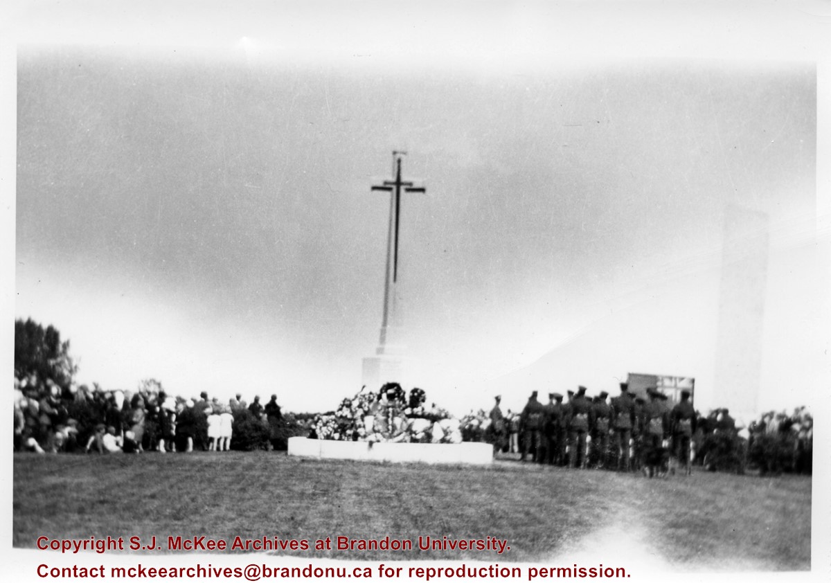
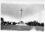
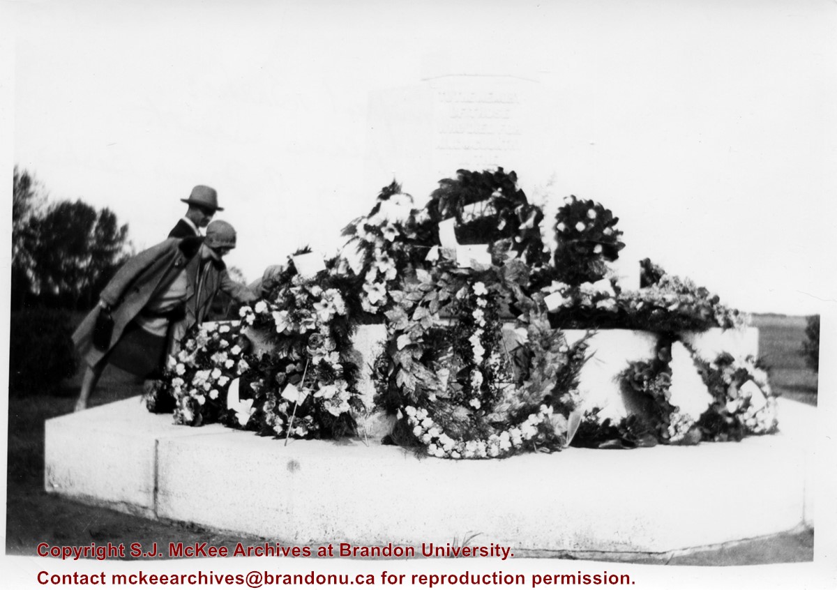
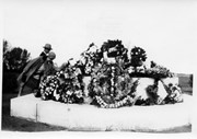
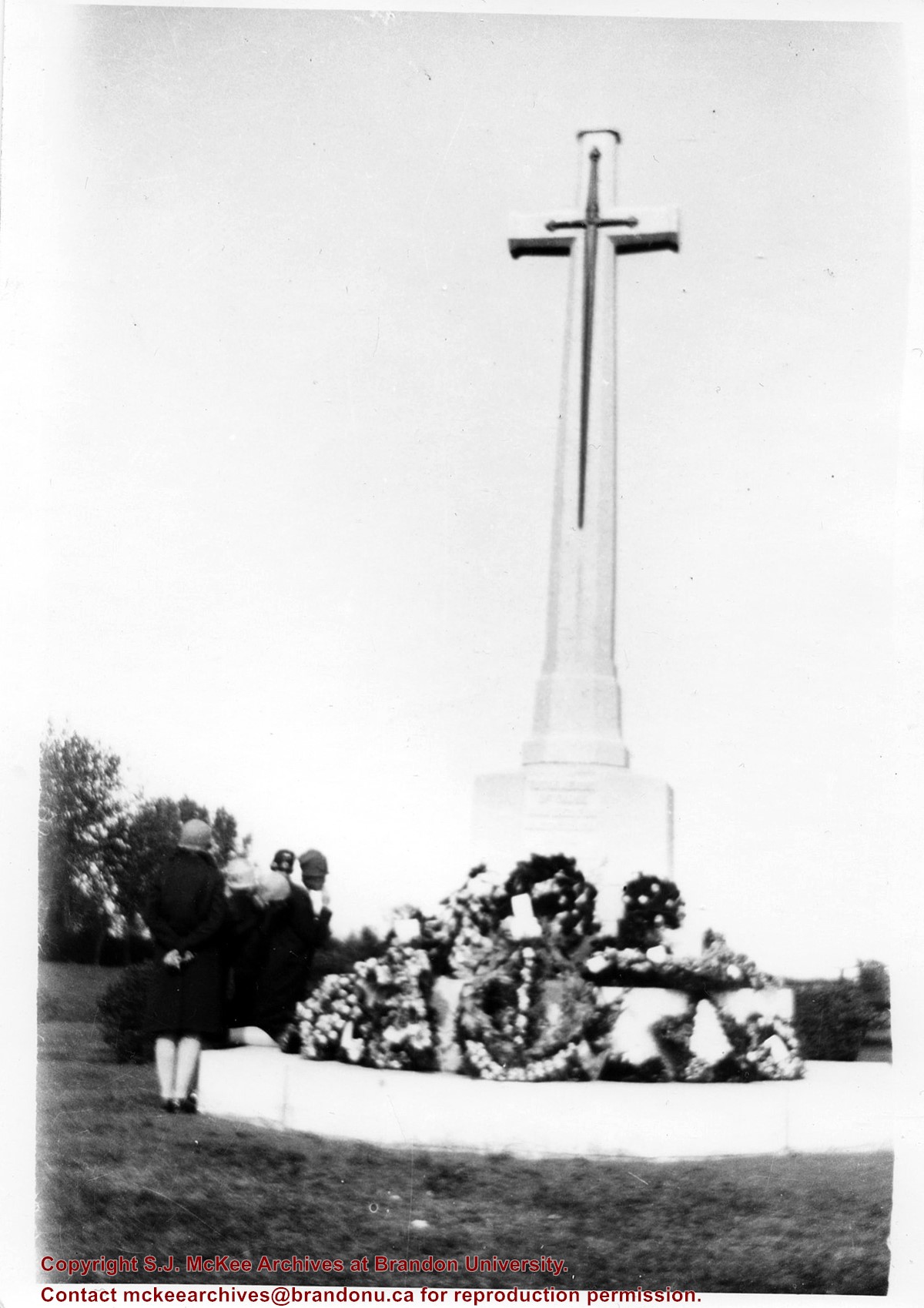
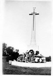
According to Veterans' Affairs Canada, there are 25 Crosses of Sacrifice in North America. The crosses were designed by the Canadian War Graves Commission's (CWGC) architect Sir Reginald Bloomfield, who designed a stone cross affixed with a bronze symbolic sword. The CWGC granted the Brandon Municipal Cemetery permission to privately erect the Cross of Sacrifice in its cemetery in exchange for maintaining the war graves in its cemetery.
The Brandon Great War Veterans Association erected the Cross of Sacrifice in the Brandon Municipal Cemetery in 1924 after a 10-day public fundraising campaign. At the time the Brandon Daily Sun reported that the Veterans Association required $5,000 to pay for the cross and the campaign ultimately raised $7,500. The memorial was initially dedicated to the local citizens who died as a result of the First World War.
Custodial History
Donated to Fred McGuinness by G. Baldock in 1971
Scope and Content
Photograph is of a memorial service at the Cross of Sacrifice in the Brandon Municipal Cemetery. Members of the public are standing to the north of the cross, while soldiers and veterans stand to the south. A number of wreaths have been placed at the base of the monument.
Notes
Writing on the back of the photograph reads: 5 prints. Dedication of the war memorial. around 1926-1927-28. I was scout master under Comissioner Harry Booth. P.E.H.
According to Veterans' Affairs Canada, there are 25 Crosses of Sacrifice in North America. The crosses were designed by the Canadian War Graves Commission's (CWGC) architect Sir Reginald Bloomfield, who designed a stone cross affixed with a bronze symbolic sword. The CWGC granted the Brandon Municipal Cemetery permission to privately erect the Cross of Sacrifice in its cemetery in exchange for maintaining the war graves in its cemetery.
The Brandon Great War Veterans Association erected the Cross of Sacrifice in the Brandon Municipal Cemetery in 1924 after a 10-day public fundraising campaign. At the time the Brandon Daily Sun reported that the Veterans Association required $5,000 to pay for the cross and the campaign ultimately raised $7,500. The memorial was initially dedicated to the local citizens who died as a result of the First World War.
Private Frank Barker (#33281) died on 27 June 1918. A member of the Canadian Army Medical Corps, Pte. Barker was on the Llandovery Castle Hospital Ship when it was torpedoed.
Custodial History
Donated to Fred McGuinness by G. Baldock in 1971
Scope and Content
Photograph is of a close-up of a number of wreaths laid at the base of the Cross of Sacrifice in the Brandon Municipal Cemetery during a memorial service.
Notes
Writing on the back of the photograph reads: Winnifred Barker places wreath in memory of Frank Barker (my uncle) 1st Field Ambulance, many decorations including the "Mons Star," lost on the Hospital Ship Landovery Castle, 1918. - G. Baldock 1971 -
According to Veterans' Affairs Canada, there are 25 Crosses of Sacrifice in North America. The crosses were designed by the Canadian War Graves Commission's (CWGC) architect Sir Reginald Bloomfield, who designed a stone cross affixed with a bronze symbolic sword. The CWGC granted the Brandon Municipal Cemetery permission to privately erect the Cross of Sacrifice in its cemetery in exchange for maintaining the war graves in its cemetery.
The Brandon Great War Veterans Association erected the Cross of Sacrifice in the Brandon Municipal Cemetery in 1924 after a 10-day public fundraising campaign. At the time the Brandon Daily Sun reported that the Veterans Association required $5,000 to pay for the cross and the campaign ultimately raised $7,500. The memorial was initially dedicated to the local citizens who died as a result of the First World War.
Custodial History
Donated to Fred McGuinness by G. Baldock in 1971
Scope and Content
Photograph is of a group of people examining wreaths that have been laid at the base of the Cross of Sacrifice in the Brandon Municipal Cemetery during a memorial service.


)
)