View is southwest from the John R. Brodie Science Centre. Photograph shows: Flora Cowan Hall, the Brandon University Gymnasium, Darrach Hall, the Quill trailer and the Jeff Umphrey Centre.
The bottom right hand corner has been torn off. Both portions of the photograph are stored together.
Scope and Content
View is northwest from approximately 17th Street and Victoria Avenue. Photograph shows: the Brandon College campus and the Kinsmen Park and baseball diamond. Taken during construction of Flora Cowan Hall but before the Gymnasium was built.
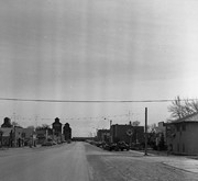
Photograph shows residential area of Lorne Avenue from 14th Street facing east.
Notes
Part of "Christie's Brandon Series of Six Colored Picture Postcards of Brandon, Manitoba, The Crown Series, Published by Christie's Bookstore, Brandon, Man." [note: missing sixth postcard]. Writing on the front of the photograph reads: Residential, Brandon, Man. Looking East.
Photograph shows a street view of Lorne Avenue and 4th Street facing west. Brandon College can be seen at the end of Lorne Avenue.
Notes
Part of "Christie's Brandon Series of Six Colored Picture Postcards of Brandon, Manitoba, The Crown Series, Published by Christie's Bookstore, Brandon, Man." [note: missing sixth postcard]. Writing on the front of the photograph reads: Residential Brandon, Man. Looking West. Photograph likely taken from St. Augustine's Church.
View is southeast and was probably taken from the roof of McMaster Hall. Photograph shows the greenhouse situated on top of the John R. Brodie Science Centre.
View is northeast, taken from the John R. Brodie Science Centre. Photograph shows: the Brandon College Building, the Student Services H-Hut, the Education Building, and the Student Union Building (Citizens' Science Building), as well as 18th Street and some houses. The trailer to the south of the Education Building was a Canada Manpower office in the 1960s. It was latter moved over by the Gymnasium, where it became the Quill office.


