[The land on which city hall stood in this photo is now known as Princess Park. P.E. 01/06/09]
Custodial History
For custodial history see the collection level description of the Lawrence Stuckey collection.
Scope and Content
Princess Avenue, showing City Hall & CKX radio tower
Notes
[View is from 9th Street looking east. P.E.]
"Radio towers of CKX on city hall grounds were 150 feet tall; Studio and transmitter were on the east side of city hall." - Fred McGuinness collection (20-2009).
Postcard shows an aerial view of 9th Street facing south in Brandon, Manitoba. Visible businesses and landmarks include: Beaubier Hotel, YMCA/police station, the original CKX Radio station towers on 8th Street (est. 1928 - moved 1940), the old City Hall, Prince Edward Hotel, and the original Manitoba Power commission smokestack on 10th Street.
Notes
Writing on the front of the photograph reads: Brandon, Man., Jerrett Photo. This photograph shows a rare view of the 800-block between Rosser and Princess Avenues.
Photograph shows the intersection of 10th Street and Princess Avenue, Brandon, Manitoba. View is facing northwest along west side of the 100-block of 10th Street. A stationary policeman/divider is at the centre of the intersection. Visible businesses include: Doig's, Plaza Shoe Shop, and Cambridge Clothes Shop. A horse-drawn sled is parked in front of Doig's store. The Olympia Block, Cecil Hotel, and CPR Station are visible in the background.
For custodial history see the collection level description of the Lawrence Stuckey collection.
Scope and Content
Aerial view of downtown Brandon, including area of new Gallery Mall.
Notes
[This eastward aerial view of downtown Brandon seems to portray an outdoor second-story parking garage proposed by the architectural firm Ward, MacDonald and Partners. The proposed overhead parking is depicted as running continuously from Sixth Street to Tenth Street along Rosser Avenue. The negative appears to have been made by photographing an existing illustration. P.E. 03/06/09]
After demise of the streetcars, a transit system was started by MacArthur Transportation Co. with three routes, an east end loop, a south end loop, and a west end loop, with terminal at 8th St. & Rosser Ave. The E & W was operated as a continuous route with two locally built coach bodies on new Maple Leaf trucks. A secondhand, larger, Leland coach was acquired for the S. end, which was replaced by a large GMC about 1938.
Custodial History
For custodial history see the collection level description of the Lawrence Stuckey collection.
Red ink stain is on the front right corner of postcard
Scope and Content
Photograph shows 10th Street facing south from Princess Avenue. Visible landmarks and businesses include: Manitoba Power Commission (MPC)'s power sub-station, First Baptist Church, Wheat City Arena, and the grand stand at the Exhibition Grounds.
The partial sign visible at the bottom of the photograph on the east side of 10th Street reads Yates and Neale, which refers to a plumbing and heating company that dissolved in 1943 to be replaced by Neale, Stothard and Chapman.
Businesses on the west side of 10th Street include: Dominion Tire & Radio Co., Bolts Barber Shop, Elviss T.E. Co. Stables.
Notes
Information concerning Yates and Neale courtesy Jack Stothard. Writing on the front of the postcard reads: Brandon, Looking S.W., Jerrett Photo. This photograph shows a rare view of the 200-block of 10th Street.
Photograph of east side of 10th Street, Brandon, Manitoba, between Rosser and Princess Avenues. Visible businesses include: The Bank of Montreal, Barclay's Shoe Store, Carlton Cafe (in the former Cigar Factory), and Ted Heming Jewellers. The McKenzie Seed building is visible in the background.
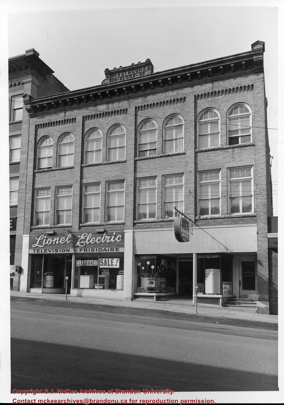
Photograph shows the east side of 10th Street, Brandon, Manitoba, between Rosser and Princess Avenues. Businesses visible in the Brown Block include (from north to south): Singer, Pittsburgh Paint & Glass, O. Stark & Son, Elna Sewing Centre, and Canadian Pacific Telegraphs. The Prince Edward Hotel is visible in the background.
Photograph shows the northwest corner of 10th Street and Princess Avenue. Traffic on the west side of Princess Avenue appears to travelling both ways. A taxi waits at the intersection.
Above the west entrance on the corner building is an electric sign that spells "Hughes Bldg." A second storey has been added to the portion of the Doig's shop that is adjacent to the Alexandra Block.


.jpg?width=1200&404=no-img.jpg&watermark=wmk)
.jpg?width=180&404=no-img.jpg)


.jpg?width=1200&404=no-img.jpg&watermark=wmk)
.jpg?width=180&404=no-img.jpg)
.jpg?width=1200&404=no-img.jpg&watermark=wmk)
.jpg?width=180&404=no-img.jpg)
.jpg?width=1200&404=no-img.jpg&watermark=wmk)
.jpg?width=180&404=no-img.jpg)


.jpg?width=1200&404=no-img.jpg&watermark=wmk)
.jpg?width=180&404=no-img.jpg)
.jpg?width=1200&404=no-img.jpg&watermark=wmk)
.jpg?width=180&404=no-img.jpg)
.jpg?width=1200&404=no-img.jpg&watermark=wmk)
.jpg?width=180&404=no-img.jpg)
.jpg?width=1200&404=no-img.jpg&watermark=wmk)
.jpg?width=180&404=no-img.jpg)
.jpg?width=1200&404=no-img.jpg&watermark=wmk)
.jpg?width=180&404=no-img.jpg)


.jpg%3fmaxheight%3d1000%26maxwidth%3d1000%26watermark%3dwmk&description=Pacific+Avenue+-+west+of+Tenth+Street)
.jpg%3fmaxheight%3d1000%26maxwidth%3d1000%26watermark%3dwmk&description=Pacific+Avenue+-+west+of+Tenth+Street)
.jpg%3fmaxheight%3d1000%26maxwidth%3d1000%26watermark%3dwmk&description=Pacific+Avenue+-+west+of+Tenth+Street)
.jpg%3fmaxheight%3d1000%26maxwidth%3d1000%26watermark%3dwmk&description=Pacific+Avenue+-+west+of+Tenth+Street)
.jpg%3fmaxheight%3d1000%26maxwidth%3d1000%26watermark%3dwmk&description=Aerial+View+of+Core+Area)
.jpg%3fmaxheight%3d1000%26maxwidth%3d1000%26watermark%3dwmk&description=Aerial+View+of+Core+Area)
.jpg%3fmaxheight%3d1000%26maxwidth%3d1000%26watermark%3dwmk&description=Northeast+view+from+100+block+of+Tenth+Street)
.jpg%3fmaxheight%3d1000%26maxwidth%3d1000%26watermark%3dwmk&description=East+view+from+100+block+of+Tenth+Street)
.jpg%3fmaxheight%3d1000%26maxwidth%3d1000%26watermark%3dwmk&description=East+view+from+100+block+of+Tenth+Street)