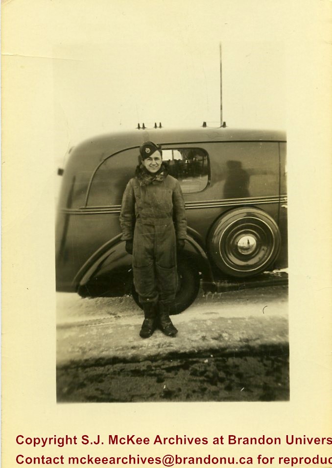
Suffield, Alberta, is situated approximately 40km northwest of Medicine Hat, Alberta. A few "large explosive events" (100 to 500 tons) were conducted at the Defence Research Board's (DRB) Suffield Experimental Station in the 1960s. On 19 January 1961, Medicine Hat citizens felt tremors in the community as a result of five tons of TNT being detonated at the station. The station director attributed this anomaly to freak atmospheric and weather conditions. At the time the DRB was testing the effects of shock waves on military equipment.
In July 1964, the Suffield Experimental Station detonated 30,600 blocks of TNT - 500 tons - to test the largest, non-nuclear, non-confined, surface blast. Placed in various sections radiating from ground zero to test the effects of the blast were targets, dummy-men, miscellaneous instruments, mines, model ships, nose cones, repirators, vehicles, subterranean chambers, shelters, tunnels, foxholes, and trenches. Several hundred people were expected to observe the blast, including 80 "official observers" and a VIP party of military and research personnel from Canada, the United States, and Britain.
(Sources: "Hellyer Heads VIP List Coming Here for SES Blast," Medicine Hat News, 09 July 1964, 7; Patrick J.Roe, "Blast Area Awaits a Cloudless Day," Medicine Hat News, 16 July 1964, 2; "Suffield Explosion Felt Here," Medicine Hat News, 19 January 1961, 7)
Scope and Content
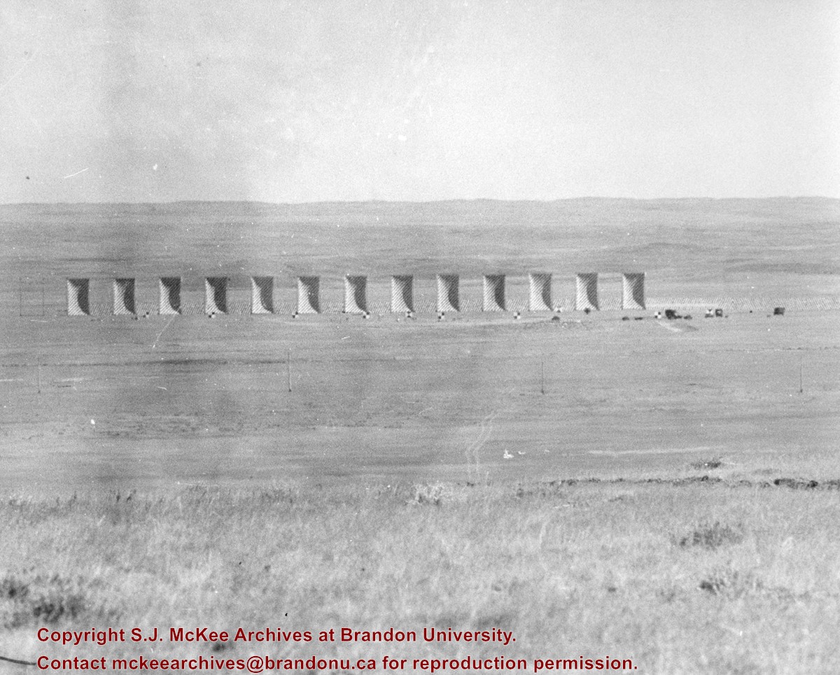
Photograph shows blast targets/dummies pre-detonation at the Suffield Experimental Station.
Suffield, Alberta, is situated approximately 40km northwest of Medicine Hat, Alberta. A few "large explosive events" (100 to 500 tons) were conducted at the Defence Research Board's (DRB) Suffield Experimental Station in the 1960s. On 19 January 1961, Medicine Hat citizens felt tremors in the community as a result of five tons of TNT being detonated at the station. The station director attributed this anomaly to freak atmospheric and weather conditions. At the time the DRB was testing the effects of shock waves on military equipment.
In July 1964, the Suffield Experimental Station detonated 30,600 blocks of TNT - 500 tons - to test the largest, non-nuclear, non-confined, surface blast. Placed in various sections radiating from ground zero to test the effects of the blast were targets, dummy-men, miscellaneous instruments, mines, model ships, nose cones, repirators, vehicles, subterranean chambers, shelters, tunnels, foxholes, and trenches. Several hundred people were expected to observe the blast, including 80 "official observers" and a VIP party of military and research personnel from Canada, the United States, and Britain.
(Sources: "Hellyer Heads VIP List Coming Here for SES Blast," Medicine Hat News, 09 July 1964, 7; Patrick J.Roe, "Blast Area Awaits a Cloudless Day," Medicine Hat News, 16 July 1964, 2; "Suffield Explosion Felt Here," Medicine Hat News, 19 January 1961, 7)
Scope and Content
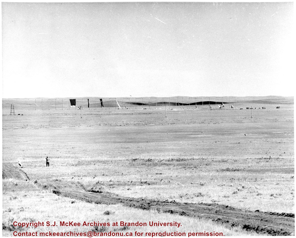
Photograph shows blast targets/dummies post-detonation at the Suffield Experimental Station.
Emulsion is cracking and photograph is starting to warp
History / Biographical
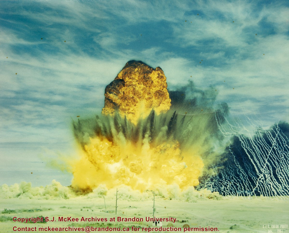
Suffield, Alberta, is situated approximately 40km northwest of Medicine Hat, Alberta. A few "large explosive events" (100 to 500 tons) were conducted at the Defence Research Board's (DRB) Suffield Experimental Station in the 1960s. On 19 January 1961, Medicine Hat citizens felt tremors in the community as a result of five tons of TNT being detonated at the station. The station director attributed this anomaly to freak atmospheric and weather conditions. At the time the DRB was testing the effects of shock waves on military equipment.
In July 1964, the Suffield Experimental Station detonated 30,600 blocks of TNT - 500 tons - to test the largest, non-nuclear, non-confined, surface blast. Placed in various sections radiating from ground zero to test the effects of the blast were targets, dummy-men, miscellaneous instruments, mines, model ships, nose cones, repirators, vehicles, subterranean chambers, shelters, tunnels, foxholes, and trenches. Several hundred people were expected to observe the blast, including 80 "official observers" and a VIP party of military and research personnel from Canada, the United States, and Britain.
(Sources: "Hellyer Heads VIP List Coming Here for SES Blast," Medicine Hat News, 09 July 1964, 7; Patrick J.Roe, "Blast Area Awaits a Cloudless Day," Medicine Hat News, 16 July 1964, 2; "Suffield Explosion Felt Here," Medicine Hat News, 19 January 1961, 7)
Scope and Content
Photograph shows a detonation at the Suffield Experimental Station.
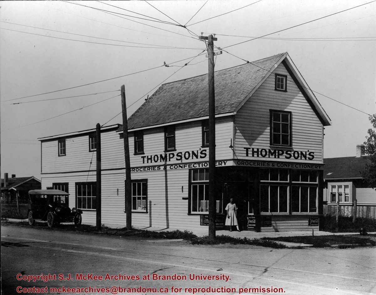
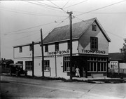
Thompson's Groceries and Confectionary was established in 1923 by Arthur Thompson (b. 1881 - d. May14, 1957) at 764 13th Street. From approximately 1925-1927, the store was operated by Alexander Thompson at 762 13th Street. The fate of the store from 1929-1935 is unclear. In 1929, Alexander Thompson was a grocer at 748 7th Street and in 1931 a Mrs. A Thompson was a grocer at 802 14th Street. There were two Thompson grocery and confectionary businesses in Brandon in 1933: Thompson's Confectionary at 745 13th Street and Thompson & Co. at 702 12th Street. In 1935, Arthur Thompson appears to have either taken over one of the earlier businesses or reopened his own grocery in its original location at 762 13th Street. He operated his store at this location into the mid-1950s. At some point following Thompson's death the building was bought by Frank Fitzpatrick and used for his upholstery store.
Custodial History
Donated by Frank Fitzpatrick.
Scope and Content
Photograph is looking northwest at the extrior of Thompson's Grocieries and Confectionary.
Notes
History/Bio information taken from Henderson's Directories (1917-1955) for Brandon, MB.
For custodial history see the collection level description of the Lawrence Stuckey collection.
Scope and Content
View of Assiniboine Avenue running west, from Ninth Street North
Notes
Second building from right - Westbrook & Fairchild Implements. At left - Western Hotel; Data [courtesy of] Roy Brown from Henderson's [Directory]; From Manitoba Archives
For custodial history see the collection level description of the Lawrence Stuckey collection.
Scope and Content
View of the southeast corner of Tenth Street and Princess Avenue, showing the Prince Edward Hotel (left) and an Imperial Oil Building (right).
Notes
The second floor of the Imperial Oil building became the Imperial Dance Garden in 1934. The small wooden post in a concrete foundation in the centre of the intersection was called a "Silent Policeman". You were supposed to keep it on your left while making a left turn. They took quite a beating.
[Information in "Notes" provided by the Fred McGuinness collection (20-2009).]
A typed label has been taped to the back of the photograph. Back of photograph has yellowed. No other degredation observed. ST/2016
Custodial History
Photograph sent to Fred McGuinness from the Winnipeg Free Press Photo Department
Scope and Content
Photograph shows a platform party in front of the Westman Centennial Auditorium. At the microphone is Mayor Ken Burgess. Seated on the mayor's left is Her Majesty Queen Elizabeth II, to his right Lorne Watson. The party may have been assembled for the founding of the Brandon University School of Music's Queen Elizabeth II building.
Notes
Photograph was collected during the research phase of the monograph "Manitoba: The Province & The People" (1987) written by Fred McGuinness and Ken Coates.
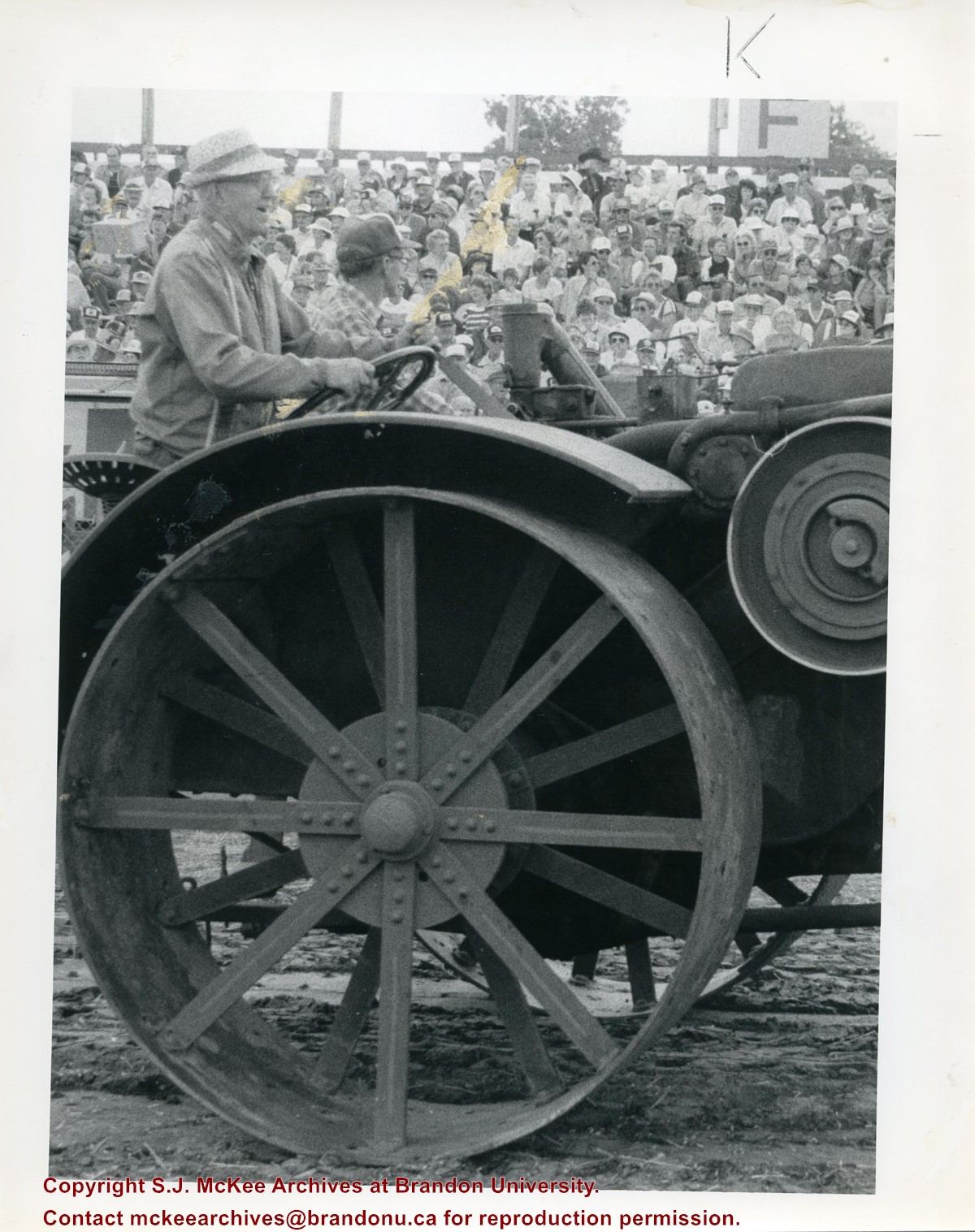
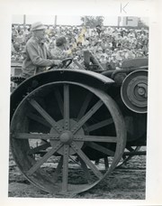
Writing on the back of the photograph reads: Ab Gowanlock 85 years old of Dauphin, two-time winner of the Brier (once in 1938 at Toronto and once in Sudbury in 1953) at the wheel of a Rumley Oil Pull tractor during the Thursday afternoon parade of steam and oil and gas tractors. Mr. Gowanlock is not a newcomer to threshing as he was involved with it on a regular basis from 1916 to 1947. dirk...shot directly into sun and was hard to print...
Emulsive side of image has residue and mock-up lines. A typed label has been taped to the back of the photograph. Back of photograph has yellowed. No other degredation observed. ST/2016
Custodial History
Photograph sent to Fred McGuinness from the Winnipeg Free Press Photo Department
Scope and Content
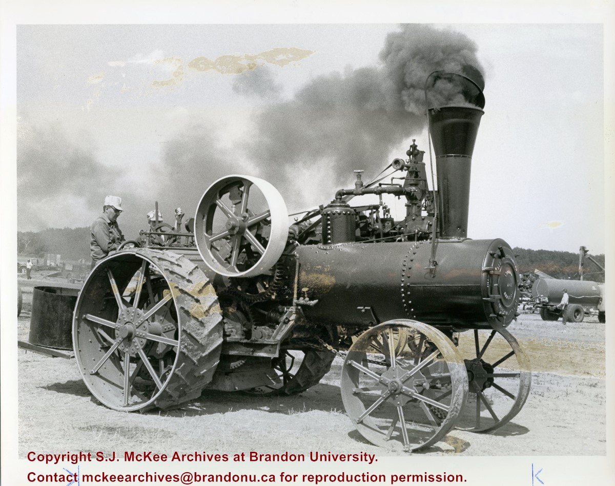
Photograph shows a steam tractor on display at the Austin, Manitoba's Threshermen's Reunion.
Notes
Photograph was collected during the research phase of the monograph "Manitoba: The Province & The People" (1987) written by Fred McGuinness and Ken Coates.
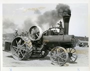
Writing on the back of the photograph reads: Kevin Milne and Makinak and Gordon Down of Winnipeg chugging up a storm at Austin Thursday. Dirk Aberson for Greg McComb. 1985
Photograph sent to Fred McGuinness from the Winnipeg Free Press Photo Department
Scope and Content
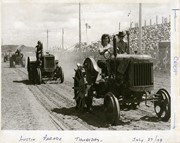
Photograph shows historic tractors on display at the Austin, Manitoba's Threshermen's Reunion. The tractors are parading on an outdoor track before a packed grandstand.
Notes
Photograph was collected during the research phase of the monograph "Manitoba: The Province & The People" (1987) written by Fred McGuinness and Ken Coates.
Writing on the front of the photograph reads: Austin Parade Thursday, July 27/79
The Brandon Club (L. of center) was built in 1904. This local businessmen's club met in the old firehall until this building was erected by them.
[The Brandon Club closed and its assets were sold at auction on 18 June 2005. P.E. 01/06/2009]
Custodial History
For custodial history see the collection level description of the Lawrence Stuckey collection.
Scope and Content
Overhead view of Princess Avenue, west of 10th Street
Notes
Taken from roof of Prince Edward Hotel. Shows: Rat Portage Lumber Co., St. Matthew's Hall, Brandon Club, In distance Brandon College, International Harvester, Pumping Station. End of brick pavement at 14th Street is notable.
The overpass is named for Brandon's first mayor, Thomas Mayne Daly, and the street on which the overpass is located. The overpass opened in October 1963.
Scope and Content
Photograph is an aerial view of the Daly 18th Street Overpass (18th Street Bridge). Visible are a number of commercial and residential buildings in the north end of Brandon, MB. The view is northeast, probably taken from the roof of the old steam plant north of 20th Street and Rosser Avenue.


.jpg?width=1200&404=no-img.jpg&watermark=wmk)
.jpg?width=180&404=no-img.jpg)


.jpg%3fmaxheight%3d1000%26maxwidth%3d1000%26watermark%3dwmk&description=Princess+Avenue+east+of+Tenth+Street)