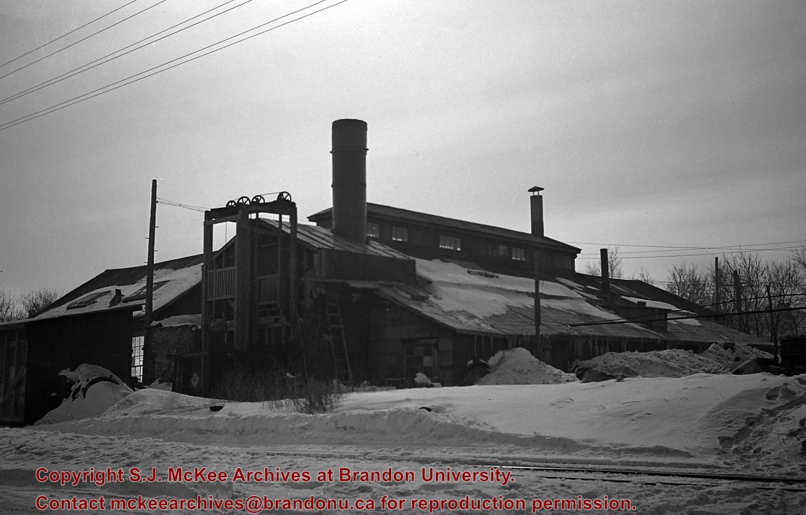
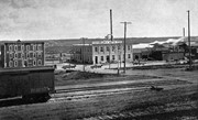
This photo provides a good view of the coal sheds along CPR track. Coal was unloaded from boxcars into roof hatches and hauled by drays from doors on avenue side. Only part of a long row of these commercial coal sheds is shown. As a boy I remember several fires in them. LAS.
Custodial History
For custodial history see the collection level description of the Lawrence Stuckey collection.
Scope and Content
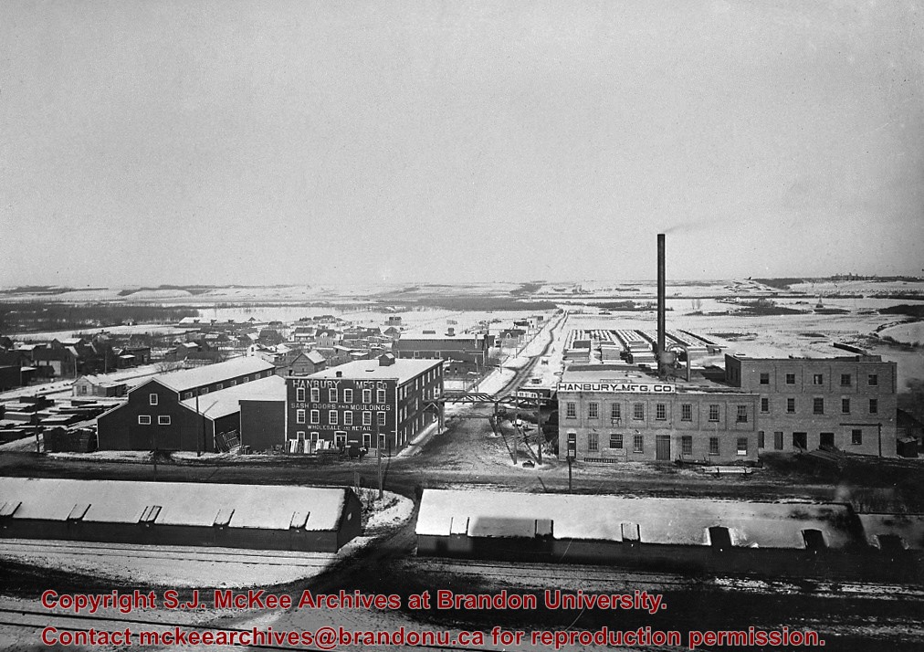
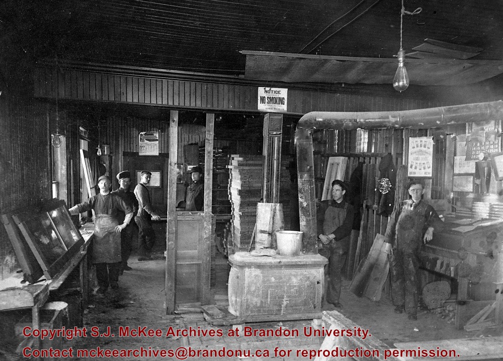
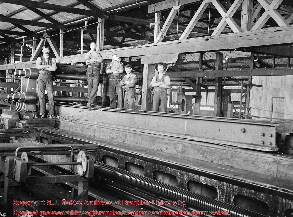
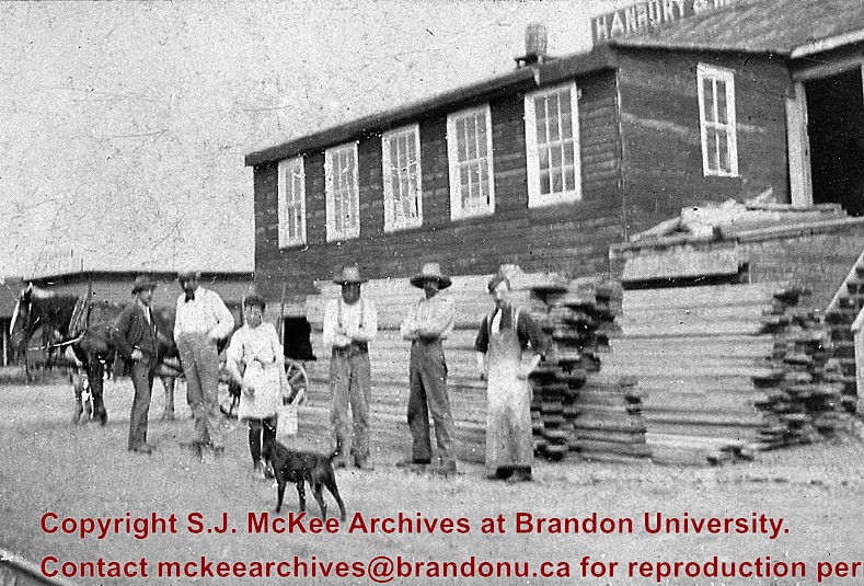
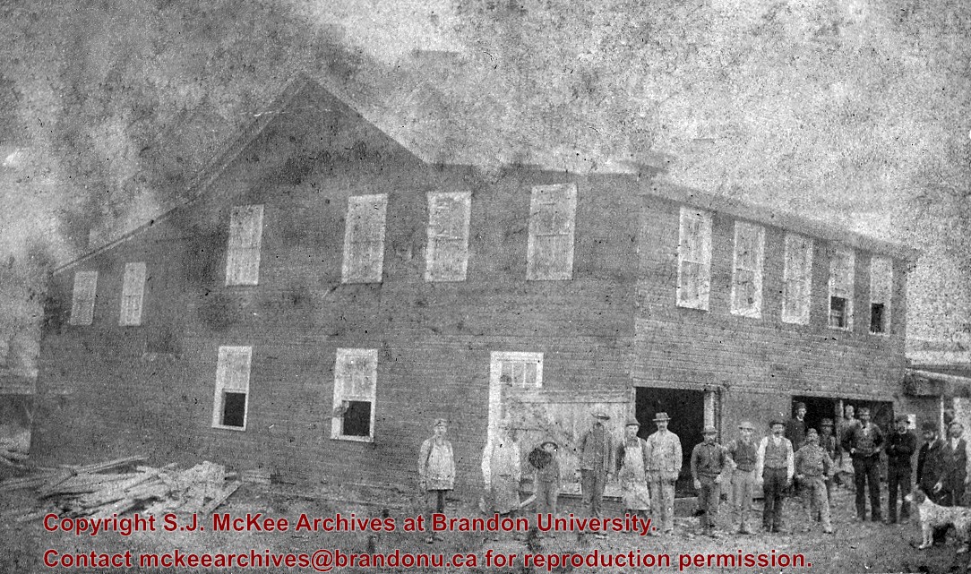
Hanbury Manufacturing Co.
Notes
View of complete Hanbury Manufacturing complex (from Pacific Avenue looking north), showing the intersection of 6th Street & Assiniboine Ave.
Note overhead walkway over 6th St. between buildings
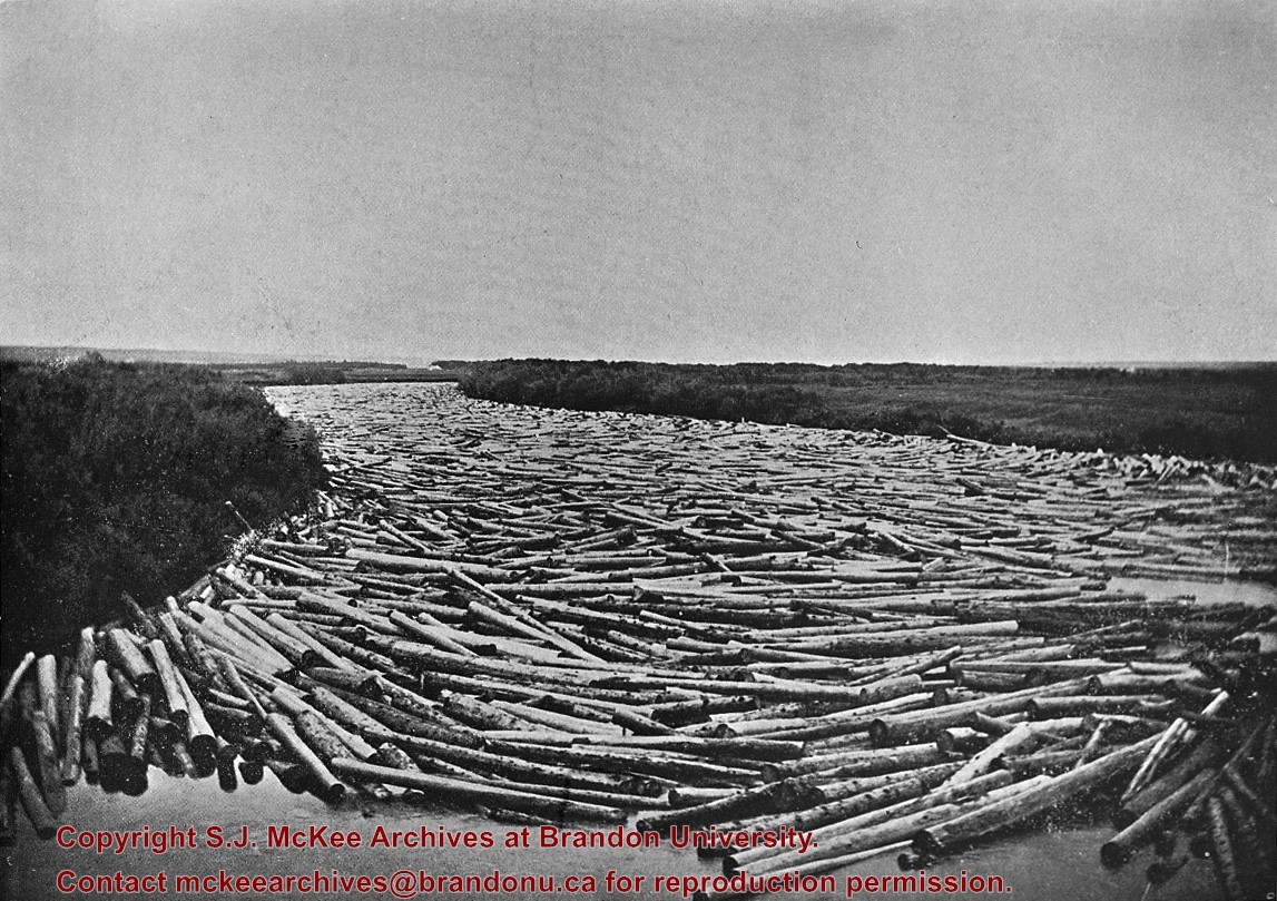
Probably the peak of the sawmilling industry in Brandon was "The Big Drive" in 1910, when 125 drivers brought 5 million board feet of timber down the Assiniboine to Hanbury's Mill.
Most of these logs were cut in the Riding Mountains in winter and floated down the Little Saskatchewan and Birdtail Rivers to the Assiniboine.
Custodial History
For custodial history see the collection level description of the Lawrence Stuckey collection.
Scope and Content
Logs, destined for Hanbury Manufacturing Co., in the Assiniboine River
Notes
Looking north from 3rd Street.
[This negative was produced using a previously published image (P.E.).]
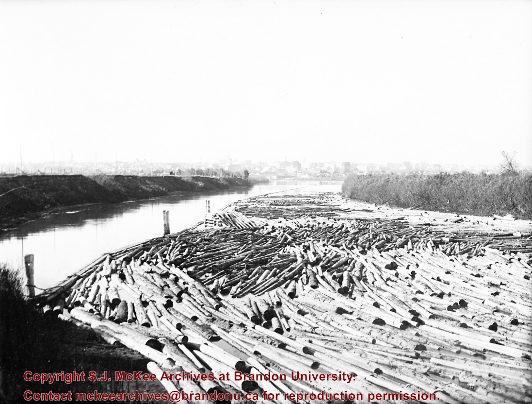
Probably the peak of the sawmilling industry in Brandon was "The Big Drive" in 1910, when 125 drivers brought 5 million board feet of timber down the Assiniboine to Hanbury's Mill
Most of these logs were cut in the Riding Mountains in winter and floated down the Little Saskatchewan and Birdtail Rivers to the Assiniboine.
Custodial History
For custodial history see the collection level description of the Lawrence Stuckey collection.
Scope and Content
Logs, destined for Hanbury Manufacturing Co., in the Assiniboine River
Notes
View from First Street North
Courtesy of the family of E.C. Higgins (Mrs. Millen Dunbar nee May Higgins).
These blocks of ice were used to fill the ice houses of the Wheat City Ice Co. (located north of Rosser Avenue on the west side of 15th Street, and south of Princess Avenue on the east side of 17th Street), the CPR icehouses (at the station and 3rd St. & Assiniboine Ave), and the CNR icehouse (at Forth Street and McTavish Avenue). In addition, large quantities of ice were shipped to smaller towns in railcars (usually old refrigerator cars).
Custodial History
For custodial history see the collection level description of the Lawrence Stuckey collection.
Scope and Content
Cutting ice from the Assiniboine River
Notes
This is one of five images that show the method in which ice is cut into blocks and loaded onto sleighs or trucks. Note the large draft horses still in use at this date.
[Mr. Stuckey put five negatives into the same envelope. We have separated them and numbered them H12(1) to H12(5).]
Additional information provided by the Fred McGuinness collection (20-2009).
As a boy my father pointed out this pile of bricks, and pit beside it, and told me a small brick plant had been established here in the early days. The product was of poor quality and the business never became established. LAS.
Custodial History
For custodial history see the collection level description of the Lawrence Stuckey collection.
Scope and Content
Spring Park brick pile near the CPR grade
Notes
Located just south of the CPR mainline at Mile 3 [three miles west of Brandon. P.E.]
[Mr. Stuckey put three negatives in same envelope. We have separated them and numbered them H13(1), H13(2) and H13(3).]
As a boy my father pointed out an old pile of bricks, and pit beside it, and told me a small brick plant had been established here in the early days. The product was of poor quality and the business never became established. LAS.
Custodial History
For custodial history see the collection level description of the Lawrence Stuckey collection.
Scope and Content
Area nearby the Spring Park brick pile
Notes
Located just south of the CPR mainline at Mile 3 [three miles west of Brandon. P.E.]
[Mr. Stuckey put three negatives in same envelope. We have separated them and numbered them H13(1), H13(2) and H13(3).]
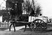
William A. Fleming, Brandon's first water dealer, is said to have begun his business in 1881. He sold drinking water for 5 cents per pail from the 1920s through the mid 1930s. The source of his water was a well located on the east side of the 100 block of 12th Street. Fleming's business was taken over by two men with a water tank on a truck, and continued till 1946 when it was closed due to contamination.
Custodial History
For custodial history see the collection level description of the Lawrence Stuckey collection.
Scope and Content
Mr. Wm. Fleming, Water Dealer, with horse and water cart
Notes
Ad on cart: W.H. Mallett Jeweller Issuer of Marriage Licenses.
Photo courtesy of the Assiniboine Historical Society.
.jpg?width=1200&404=no-img.jpg&watermark=wmk)
.jpg?width=180&404=no-img.jpg)
.jpg?width=1200&404=no-img.jpg&watermark=wmk)
.jpg?width=180&404=no-img.jpg)
.jpg?width=1200&404=no-img.jpg&watermark=wmk)
.jpg?width=180&404=no-img.jpg)
.jpg?width=1200&404=no-img.jpg&watermark=wmk)
.jpg?width=180&404=no-img.jpg)
.jpg?width=1200&404=no-img.jpg&watermark=wmk)
.jpg?width=180&404=no-img.jpg)
.jpg?width=1200&404=no-img.jpg&watermark=wmk)
.jpg?width=180&404=no-img.jpg)
.jpg?width=1200&404=no-img.jpg&watermark=wmk)
.jpg?width=180&404=no-img.jpg)
.jpg?width=1200&404=no-img.jpg&watermark=wmk)
.jpg?width=180&404=no-img.jpg)

.jpg?width=1200&404=no-img.jpg&watermark=wmk)
.jpg?width=180&404=no-img.jpg)
.jpg?width=1200&404=no-img.jpg&watermark=wmk)
.jpg?width=180&404=no-img.jpg)

.jpg%3fmaxheight%3d1000%26maxwidth%3d1000%26watermark%3dwmk&description=Cutting+Ice+from+the+Assiniboine+River)
.jpg%3fmaxheight%3d1000%26maxwidth%3d1000%26watermark%3dwmk&description=Cutting+Ice+from+the+Assiniboine+River)
.jpg%3fmaxheight%3d1000%26maxwidth%3d1000%26watermark%3dwmk&description=Cutting+Ice+from+the+Assiniboine+River)
.jpg%3fmaxheight%3d1000%26maxwidth%3d1000%26watermark%3dwmk&description=Cutting+Ice+from+the+Assiniboine+River)
.jpg%3fmaxheight%3d1000%26maxwidth%3d1000%26watermark%3dwmk&description=Cutting+Ice+from+the+Assiniboine+River)
.jpg%3fmaxheight%3d1000%26maxwidth%3d1000%26watermark%3dwmk&description=Spring+Park+Brick+Pile)
.jpg%3fmaxheight%3d1000%26maxwidth%3d1000%26watermark%3dwmk&description=Spring+Park+Brick+Pile)
.jpg%3fmaxheight%3d1000%26maxwidth%3d1000%26watermark%3dwmk&description=Spring+Park+Brick+Pile)
.jpg%3fmaxheight%3d1000%26maxwidth%3d1000%26watermark%3dwmk&description=Metev+Woolen+Mills+Ltd.)
.jpg%3fmaxheight%3d1000%26maxwidth%3d1000%26watermark%3dwmk&description=Metev+Woolen+Mills+Ltd.)