Situated in the R.M. of Whitehead on the Little Saskatchewan River, the 10 Mile Dam was a 14 kilometer transmission line that supplied the city of Brandon with power. The Brandon Electric Light Company built the dam in 1900 and it is considered Manitoba's first hydroelectic power generating station. The dam spanned approximately 80 meters and was constructed from timber and reinforced with clay and stone. The station was decommissioned in 1924.
Scope and Content
Photograph shows 10 Mile Dam, also known as the Brandon Dam or Minnedosa River Hydro Plant.
Notes
Writing on the back of the photograph reads: "10 mile dam". Biographical information obtained from Manitoba Historical Society.
Situated in the R.M. of Whitehead on the Little Saskatchewan River, the 10 Mile Dam was a 14 kilometer transmission line that supplied the city of Brandon with power. The Brandon Electric Light Company built the dam in 1900 and it is considered Manitoba's first hydroelectic power generating station. The dam spanned approximately 80 meters and was constructed from timber and reinforced with clay and stone. The station was decommissioned in 1924.
Alonzo Archibald Rowe (b. 1862, London, ON; d. 22 Oct 1951, Brandon). The Rowes were considered Brandon area pioneers. Alonzo’s father, Alonzo L. Rowe, came to Brandon with his family in 1881, where the family had a furniture and undertaker business on the west side of 10th Street between Rosser and Princess Avenues. In 1885, the family began farming west of Brandon and Alonzo Archibald served as a councilor and then a reeve in the R.M. of Whitehead. He returned to Brandon in 1907 and served with the Brandon Police Department until 1910, when he returned to farming, this time in Arrow River. A.A. Rowe returned to Brandon in 1915 to work as a Provincial Licenses Inspector, a position he held until 1938. (Source: Obituary, Brandon Daily Sun 22 Oct 1951)
Custodial History
Photograph was in possession of Mrs. Ruby Miles, who passed the image on to Fred McGuinness. McGuinness makes reference to Mrs. Miles and this photograph in his Sunbeams column (Source: F.A. Rosser, "Another interesting chat with a daughter of the plains," Brandon Sun 18 Aug 1981).
Scope and Content
Photograph shows four fishermen at 10 Mile Dam, also known as the Brandon Dam or Minnedosa River Hydro Plant. The fishermen in the photo are identified as George H. Rowe and his father A.A. Rowe, Dr. Wilfred Bigelow, and Al Collins.
Notes
Writing on the back of the photograph reads: at Brandon Dam, [right to left] son and father - George H. ROWE, Mr. A.A. ROWE, Dr. BIGELOW, Al COLLINS (dam?, 1906?, George born March 1897); Jerrett's Photo-Services, May 7 1938.
Photographs have been glued to a backing board that has warped over time
Scope and Content
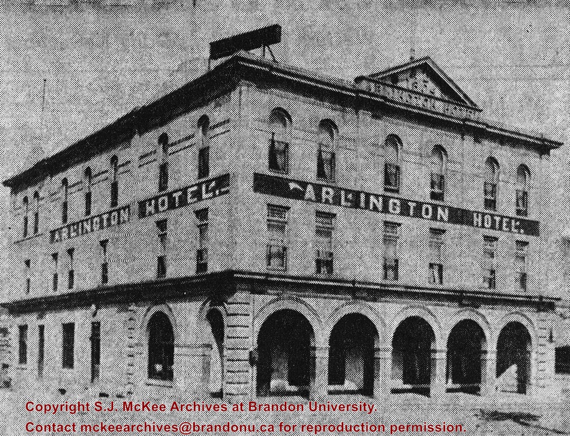
Photograph shows street view of north side of Rosser Avenue, primarily the 700 block, along which sewer pipe is being laid. Visible buildings and businesses include: The Fleming Block with Lowes Brothers Clothing and Manitoba Farmers Hedge and Wire Fence Company, the Beaubier Block and its Empire Hotel, A.M. Percival (a grocer), the Brandon Hardware Company (600 block), and the Arlington Hotel (500 block) are visible along the north side of the avenue. The Bank of Hamilton Building is on the southeast corner of 8th Street and Rosser Avenue.
Notes
Writing on the front of the photograph matting reads: 290. Page appears to be from a photo album.
According to the Manitoba Historical Society, the Volunteer Monument was unveiled at Winnipeg's Old City Hall on September 28, 1886. The monument commemorated the soldiers of 90th Winnipeg Rifles (also known as the "Little Black Devils") who were killed during the 1885 North West Rebellion. In 1968, the monument was moved to the east side of Main Street, between the Centennial Concert Hall and the Manitoba Museum.
Scope and Content
Photograph shows a parade marching south along Main Street in front of the Volunteer Monument on Winnipeg's Old City Hall grounds (1886-1962). The parade was in honour of Queen Victoria's Diamond Jubilee that was held June 22, 1899. Businesses visible on the west (left) side of Main Street include: the Great Northern Railway Line, Gurney Stove & Range Co., Sherman House, The Arlington Hotel, Hurtley & Co., Central Drug Hall, Inman Optical Co. On the east side of Main Street, the Conferation Life Block is draped with bunting and a large ensign flag is flying from its tower. Specators line the streets and can be seen on roof tops and leaning from windows.
Notes
The front of the photograph reads: Jublee [sic.] Procession June 22/99 Winnipeg
Situated in the R.M. of Whitehead on the Little Saskatchewan River, the 10 Mile Dam was a 14 kilometer transmission line that supplied the city of Brandon with power. The Brandon Electric Light Company built the dam in 1900 and it is considered Manitoba's first hydroelectic power generating station. The dam spanned approximately 80 meters and was constructed from timber and reinforced with clay and stone. The station was decommissioned in 1924.
Scope and Content
Photograph shows 10 Mile Dam, also known as the Brandon Dam or Minnedosa River Hydro Plant. The dam's timber construction is quite evident in the picture.
Notes
Writing on the back of the photograph reads: McGuinness (Manitoba Hydro), on Little Saskatchewan.
Photograph shows a panorama, bird's-eye-view of downtown Brandon, between Pacific and Rosser Avenues and 7th Street facing east. Photoraph likely taken from the McKenzie Seeds Building. Visible businesses include: Western Canada Flour Mills, Hanbury Hardware Co. Ltd., Cockshutt Plow Co., New Pacific Hotel, Gordon McKay Building, and Arlington Hotel.
Notes
Part of "Souvenir of Brandon, Manitoba, Canada [viewbook], Printed by Photogelatine Engraving Co. Limited, Ottawa." Dates obtained from the Burchill's Music Store Henderson's Brandon City Directory listings (1927-1929). Writing on the front of the photograph reads: Panorama of Brandon, Man.


