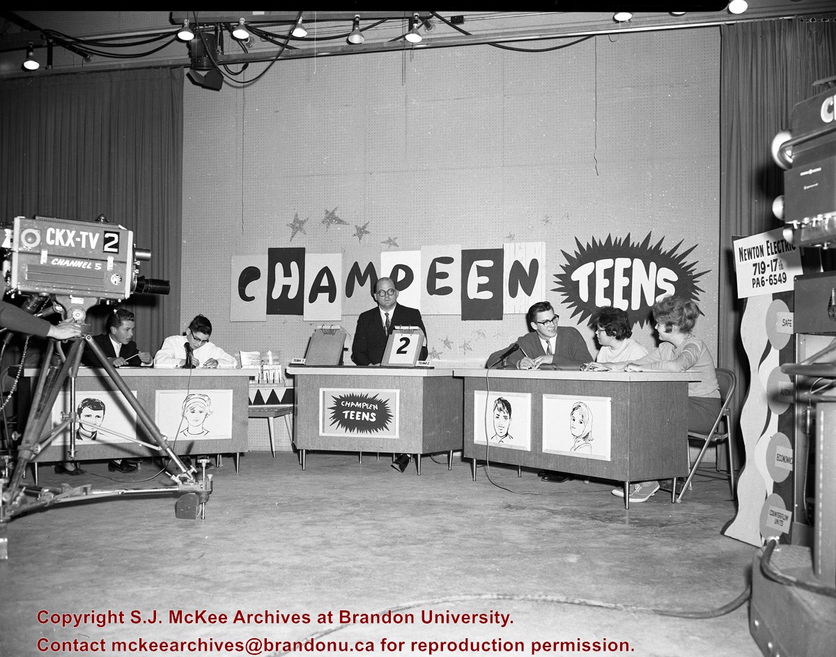
For custodial history see the collection level description of the Lawrence Stuckey collection.
Scope and Content
View of the southeast corner of Tenth Street and Princess Avenue, showing the Prince Edward Hotel (left) and an Imperial Oil Building (right).
Notes
The second floor of the Imperial Oil building became the Imperial Dance Garden in 1934. The small wooden post in a concrete foundation in the centre of the intersection was called a "Silent Policeman". You were supposed to keep it on your left while making a left turn. They took quite a beating.
[Information in "Notes" provided by the Fred McGuinness collection (20-2009).]
After demise of the streetcars, a transit system was started by MacArthur Transportation Co. with three routes, an east end loop, a south end loop, and a west end loop, with terminal at 8th St. & Rosser Ave. The E & W was operated as a continuous route with two locally built coach bodies on new Maple Leaf trucks. A secondhand, larger, Leland coach was acquired for the S. end, which was replaced by a large GMC about 1938.
Custodial History
For custodial history see the collection level description of the Lawrence Stuckey collection.
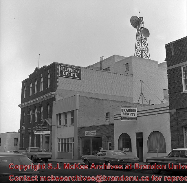
Photograph is looking northeast and shows Brandon Realty, ARM Industries Inc. (silk screen printers), Col. Ray Robinson's Auction Services, and the MTS building.
Repro Restriction
The McKee Archives is the copyright holder for the Stuckey materials.
Photograph shows the Kresge store on the southwest corner of 10th Street and Rosser Avenue. Other 10th Street businesses that are visible on the west side of the street include: James Richardson & Son Investments, Beneficial Finance and Loans, Bass' Storkland, Brandon News & Record Shop, Recreation Bowling and Billiards, and Bottomley's. The Welcome Brandon sign can be seen in the top right corner of the photograph.
Photograph of the northeast corner of 10th Street and Princess Avenue facing northeast. An Imperial Esso Dealer is situated on the southeast corner. On the northeast side the following businesses are visible: Thunderbird Bowl, Canadian Pacific Telegraphs, Pittsburgh Paint & Glass, The Strand Theatre, Trans Canada Credit Loans, Ted Heming Jewellers, Carlton Cafe, Barclay Shoe Store, Chamber of Commerce, United Cafe, and Chop Suey. An billboard for 2 Way drink is mounted on the former Campbell's Furniture Building. A sign for the Manitoba CAA Motor League hangs from a business on the southwest corner of 10th Street and Princess Avenue. Traffic on Princess Avenue, on the east side of 10th Street, is travelling one-way.
Photograph of the northeast corner of 10th Street and Princess Avenue facing northeast. An Imperial Esso Dealer is situated on the southeast corner. On the northeast side the following businesses are visible: Thunderbird Bowl, Canadian Pacific Telegraphs, Pittsburgh Paint & Glass, The Strand Theatre, Trans Canada Credit Loans, Ted Heming Jewellers, Carlton Cafe, Barclay Shoe Store, Chamber of Commerce, United Cafe, and Chop Suey. An billboard for 2 Way drink is mounted on the former Campbell's Furniture Building. A sign for the Manitoba CAA Motor League hangs from a business on the southwest corner of 10th Street and Princess Avenue. Traffic on Princess Avenue, on the east side of 10th Street, is travelling one-way.
The Royal Bank moved to this location on 26 October 1929. An existing building was renovated to accomodate the bank. On 28 May 1976 fire destroyed the buildings from the lane west to the Royal Bank.
Scope and Content
Photograph shows the south side of Rosser Avenue between 7th and 8th Streets, west of the Eaton's building. Visible shops include: Vogue [Ladies Wear], Smith's Drugs, Sobie's Tailored Undergarnments, Household Finance Loans, and The Royal Bank of Canada.
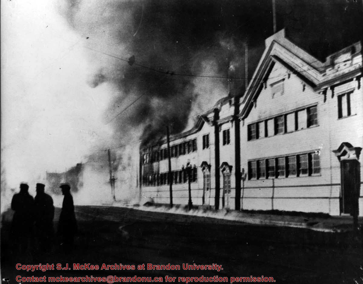
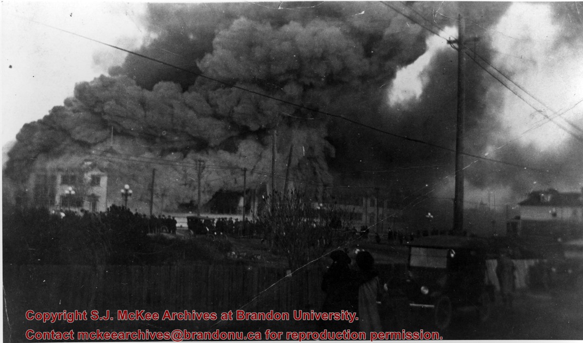
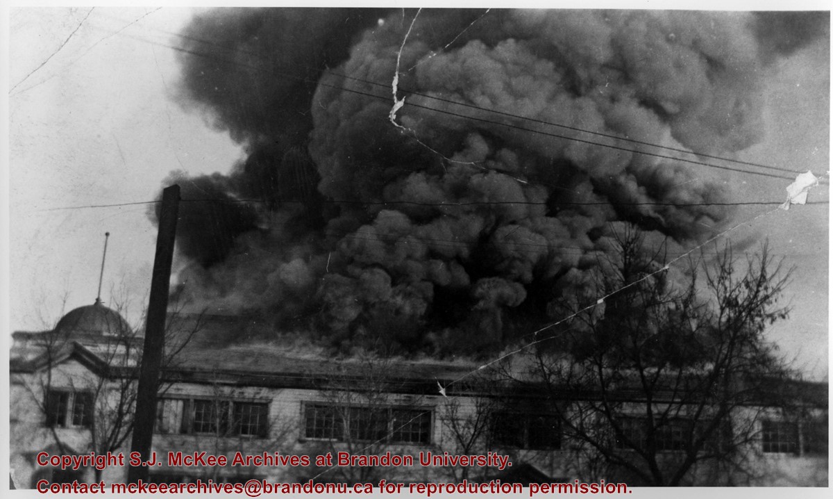
Photograph of spectators gathered to watch the Royal North-West Mounted Police (RNWMP) horse barns on fire. The barns were located in the Winter Fair Building on the Fair Grounds.
Photograph mat is bent. Emulsion problems with image.
Scope and Content
Photograph shows Rosser Avenue in its incipient stages. Canvas tents are mixed amongst wooden structures. The James Smart Hardware store, Winter & O'Neail Groceries & Provisions, and the law office of F.G.A. Henderson in the Molesworth Block can be seen on the north side of Rosser Avenue. A street sign designating 6th Street can be seen below the Winter & O'Neail sign. A horse and buggie is traveling down the dirt track that is Rosser Avenue. Groups of men can be seen congregating outside some of the local businesses.
Notes
Front of photograph reads: Rosser Avenue, Brandon 1882-1883, from east of Six Street. Back of photograph is stamped: I. Bennetto & Co., Photographers, Opposite Post-Office, Winnipeg, Man.
Photographs have been glued to a backing board that has warped over time
Scope and Content
Photograph shows street view of north side of Rosser Avenue, primarily the 700 block. Horse and buggies are travelling on the avenue and pedestrians fill the sidewalks. Union Jacks and English flags are mounted from the windows on the Fleming and Beaubier blocks. Flag banners are drapped across Rosser Avenue. Businesses visible in the Fleming Block include: Lowes Brothers Clothing and Spring Park Nurseries. Businesses visible in the Beaubier Block include the Empire Hotel. Businesses east of the Empire Hotel are grocer A.M. Percival and the Brandon Hardware Company. An advertisement for the Northern Bank is affixed to a telephone pole on the southside of the street.
Notes
Writing on the front of the photograph matting reads: July 1 1906, 314. One photograph (20-2009.8) is glued below and another, 20-2009.6, is glued on the reverse side. Page appears to be from a photo album.
Photographs have been glued to a backing board that has warped over time
Scope and Content
Photograph shows street view of north side of Rosser Avenue, primarily the 700 block. Horse and buggies are travelling on the avenue and pedestrians fill the sidewalks. Union Jacks and English flags are mounted from the windows on the Fleming and Beaubier blocks. Flag banners are drapped across Rosser Avenue. Businesses visible in the Fleming Block include: Lowes Brothers Clothing and Spring Park Nurseries. Businesses visible in the Beaubier Block include the Empire Hotel. Businesses east of the Empire Hotel are grocer A.M. Percival and the Brandon Hardware Company. An advertisement for the Northern Bank is affixed to a telephone pole on the southside of the street. The street is lined with litter and a number of dogs can be seen roaming the area.
Notes
Writing on the front of the photograph matting reads: 313 July 1906. One photograph (20-2009.8) is glued below and another, 20-2009.6, is glued on the reverse side. Page appears to be from a photo album.
Photographs have been glued to a backing board that has warped over time
History / Biographical
Photograph of possible Dakota from Sioux Valley in Brandon for the summer fair.
Scope and Content
Photograph shows street view of north side of Rosser Avenue, primarily the 700 block. Businesses visible in the Fleming Block include: Lowes Brothers Clothing, Robert Hall [Insurance Broker], Manitoba Farmers Hedge and Wire Fence Company. Businesses visible in the Beaubier Block include the Empire Hotel. Businesses east of the Empire Hotel are grocer A.M. Percival and the Brandon Hardware Company. A number of Aboriginal peoples are travelling on horseback west along Rosser Avenue as spectators look on.
Notes
Writing on the front of the photograph matting reads: 293. One photograph (20-2009.9) is glued above and two others are glued on the reverse side. Page appears to be from a photo album.
Photograph is looking north northeast and shows the Brandon Public Library, Smith's Tobacco Shop, Smith's Hairstyling for Men, Brandon Jewellers, and the Chrest Block, including Chrest Dry Cleaners.
Repro Restriction
The McKee Archives is the copyright holder for the Stuckey materials.
Photograph is looking north northeast from 11th Street and shows the Brandon Public Library, Smith's Tobacco Shop, Smith's Hairstyling for Men, Brandon Jewellers, the Chrest Block, including Chrest Dry Cleaners, Canadian Acceptance, Breslauer & Warren, Scotia Towers and the parking lot on the southside of the block.
Repro Restriction
The McKee Archives is the copyright holder for the Stuckey materials.
Photograph shows Princess Avenue facing east from 10th Street. On the north side of Princess Avenue, a B/A Service Station, Princess Cafe, Lindenberg Seeds, and the Central Fire Station are visible. Old City Hall with the war memorial and the Prince Edward Hotel are visible on the south side of Princess Avenue. Traffic is travelling one-way on Princess Avenue.


.jpg?width=1200&404=no-img.jpg&watermark=wmk)
.jpg?width=180&404=no-img.jpg)
.jpg?width=1200&404=no-img.jpg&watermark=wmk)
.jpg?width=180&404=no-img.jpg)


+-+Champeen+Teens)
+-+Don+Messer+visit)
.jpg%3fmaxheight%3d1000%26maxwidth%3d1000%26watermark%3dwmk&description=1000+block+rosser+avenue)
.jpg%3fmaxheight%3d1000%26maxwidth%3d1000%26watermark%3dwmk&description=1000+block+rosser+avenue)