Photograph shows Western Motors Ltd. on the southwest corner of 10th Street and Princess Avenue. To the west of the car dealership/garage is the Greyhound Bus Station and its Maxwell House Cafe as well as the court house.
Photographs have been glued to a backing board that has warped over time
History / Biographical
Photograph of possible Dakota from Sioux Valley in Brandon for the summer fair.
Scope and Content
Photograph shows street view of north side of Rosser Avenue, primarily the 700 block. Businesses visible in the Fleming Block include: Lowes Brothers Clothing, Robert Hall [Insurance Broker], Manitoba Farmers Hedge and Wire Fence Company. Businesses visible in the Beaubier Block include the Empire Hotel. Businesses east of the Empire Hotel are grocer A.M. Percival and the Brandon Hardware Company. A number of Aboriginal peoples are travelling on horseback west along Rosser Avenue as spectators look on.
Notes
Writing on the front of the photograph matting reads: 293. One photograph (20-2009.9) is glued above and two others are glued on the reverse side. Page appears to be from a photo album.
Photograph shows a view of downtown Brandon from the northeast corner of 10th Street and Princess Avenue. Thunderbird Bowl is in the foreground. Painted advertisements on the sides of buildings include: The Mitrou's Cafe and Tea Room and Brandon Musical Supply Ltd. Vehicles parked on 10th Street are facing north.
Notes
Photograph dated from "Tara's Bulba," the movie playing at the Strand Theatre and similiar vehicles captured in the photograph.
Photograph shows the west side of 10th Street between Rosser and Princess Avenues in the winter. Visible businesses include: Bottomley's, Simpsons-Sears, Lionel Electric, Allied Hardware Stores, Box Brothers Hardware, Doig's. Painted on the north face of the Strathcona Block are two advertisements, one for Sutherland and Robertson [Grocery] and the other for Boyd Electric Co. Ltd.
For custodial history see the collection level description of the Lawrence Stuckey collection.
Scope and Content
Southeast corner of 10th Street and Princess Ave. Showing: Prince Edward Hotel being demolished, part of Imperial Oil Building, new construction for corner building.
For custodial history see the collection level description of the Lawrence Stuckey collection.
Scope and Content
Southeast corner of 10th Street and Princess Ave. Showing: Prince Edward Hotel being demolished, part of Imperial Oil Building, new construction for corner building.
For custodial history see the collection level description of the Lawrence Stuckey collection.
Scope and Content
Southeast corner of 10th Street and Princess Ave. Showing: Prince Edward Hotel being demolished, part of Imperial Oil Building, new construction for corner building.
Photographs have been glued to a backing board that has warped over time
History / Biographical
Photograph of possible Dakota from Sioux Valley in Brandon for the summer fair.
Scope and Content
Photograph shows street view of north side of Rosser Avenue, primarily the 700 block. Businesses visible in the Fleming Block include: Lowes Brothers Clothing, Robert Hall [Insurance Broker], Manitoba Farmers Hedge and Wire Fence Company. Businesses visible in the Beaubier Block include the Empire Hotel. Businesses east of the Empire Hotel are grocer A.M. Percival and the Brandon Hardware Company. A number of Aboriginal peoples are driving horse and carriages west along Rosser Avenue as spectators look on.
Notes
Writing on the front of the photograph matting reads: 295 July 1906. One photograph (20-2009.11) is glued above and two others are glued on the reverse side. Page appears to be from a photo album.
For custodial history see the collection level description of the Lawrence Stuckey collection.
Scope and Content
Photograph is looking east down Lorne Avenue East from approximately the 13th Avenue East intersection. On the north side of the street are the Hillside Townhouses with the Lady Sylvia apartment block and Simplot Canada Ltd. in the background.
The McKee Archives is the copyright holder for the Stuckey materials.
Location Copy
1-2002.3.9.110
Storage Location
Lawrence Stuckey collection
Arrangement
[Mr. Stuckey put 5 and 5 prints negatives in the same envelope. We have separated them and numbered the negatives CA15(1) to CA15(5), and the corresponding prints CA15(1a) to CA15(5a).]
Photograph shows the northeast corner of 10th Street and Princess Avenue. OK Used Cars - Western Motors Ltds - used car lot and a building containing The Specialty Shop and another business are pictured. The exposed wall of the Brown Block has been painted over.
The McKee Archives is the copyright holder for the Stuckey materials.
Storage Location
Lawrence Stuckey collection
Arrangement
[Mr. Stuckey put one negative in an envelope and taped the print to the outside of the envelope. We have separated them and numbered the negative CA20(1) and the print CA20(1a).]
Photographs have been glued to a backing board that has warped over time
History / Biographical
Photograph of possible Dakota from Sioux Valley in Brandon for the summer fair.
Scope and Content
Photograph shows street view of north side of Rosser Avenue, primarily the 700 block. Businesses visible in the Fleming Block include: Lowes Brothers Clothing, Robert Hall [Insurance Broker], Manitoba Farmers Hedge and Wire Fence Company. Businesses visible in the Beaubier Block include the Empire Hotel. Businesses east of the Empire Hotel are grocer A.M. Percival and the Brandon Hardware Company. A number of Aboriginal peoples are driving horse and buggies west along Rosser Avenue as spectators look on.
Notes
Writing on the front of the photograph matting reads: 294 July 1906. One photograph (20-2009.10) is glued below and two others are glued on the reverse side. Page appears to be from a photo album.
Photographs have been glued to a backing board that has warped over time
History / Biographical
Photograph of possible Dakota from Sioux Valley in Brandon for the summer fair.
Scope and Content
Photograph shows street view of north side of Rosser Avenue, primarily the 700 block. Businesses visible in the Beaubier Block include the Empire Hotel. Businesses east of the Empire Hotel are grocer A.M. Percival, the Brandon Hardware Company, and the Arlington Hotel. A number of Aboriginal peoples are driving horse and buggies east along Rosser Avenue as large numbers of spectators look on.
Notes
Writing on the front of the photograph matting reads: 298. One photograph (20-2009.79) is glued above, another (20-2009.81) adjacent. One other is glued on the reverse side. Page appears to be from a photo album.
Photographs have been glued to a backing board that has warped over time
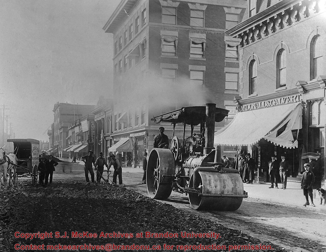
Scope and Content
Photograph shows street view of north side of Rosser Avenue, primarily the 700 block, along which sewer pipe is being laid. Visible buildings and businesses include: The Fleming Block with Lowes Brothers Clothing and Manitoba Farmers Hedge and Wire Fence Company, the Beaubier Block and its Empire Hotel, A.M. Percival (a grocer), the Brandon Hardware Company (600 block), and the Arlington Hotel (500 block) are visible along the north side of the avenue. The Bank of Hamilton Building is on the southeast corner of 8th Street and Rosser Avenue.
Notes
Writing on the front of the photograph matting reads: 290. Page appears to be from a photo album.
Photograph shows the CPR Train Station on Pacific Avenue and 10th Street.
Notes
Part of "Souvenir of Brandon, Manitoba, Canada [viewbook], Printed by Photogelatine Engraving Co. Limited, Ottawa." Dates obtained from the Burchill's Music Store Henderson's Brandon City Directory listings (1927-1929). Writing on the front of the photograph reads: CPR Station, Brandon, Man.


.jpg?width=1200&404=no-img.jpg&watermark=wmk)
.jpg?width=180&404=no-img.jpg)
.jpg?width=1200&404=no-img.jpg&watermark=wmk)
.jpg?width=180&404=no-img.jpg)
.jpg?width=1200&404=no-img.jpg&watermark=wmk)
.jpg?width=180&404=no-img.jpg)


.jpg?width=1200&404=no-img.jpg&watermark=wmk)
.jpg?width=180&404=no-img.jpg)


.jpg?width=1200&404=no-img.jpg&watermark=wmk)
.jpg?width=180&404=no-img.jpg)
.jpg?width=1200&404=no-img.jpg&watermark=wmk)
.jpg?width=180&404=no-img.jpg)


)
)
.jpg%3fmaxheight%3d1000%26maxwidth%3d1000%26watermark%3dwmk&description=Prince+Edward+Hotel+demolition)
.jpg%3fmaxheight%3d1000%26maxwidth%3d1000%26watermark%3dwmk&description=Prince+Edward+Hotel+demolition)
.jpg%3fmaxheight%3d1000%26maxwidth%3d1000%26watermark%3dwmk&description=Prince+Edward+Hotel+demolition)
.jpg%3fmaxheight%3d1000%26maxwidth%3d1000%26watermark%3dwmk&description=Townhouses+on+Lorne+Avenue+East)
.jpg%3fmaxheight%3d1000%26maxwidth%3d1000%26watermark%3dwmk&description=Skyline+from+First+Street+Bridge)
.jpg%3fmaxheight%3d1000%26maxwidth%3d1000%26watermark%3dwmk&description=Skyline+from+First+Street+Bridge)