View is north northwest from the John R. Brodie Science Center (?). Photograph shows: Citizens' Science Building, Brandon College Building and Clark Hall, the Education Building and the driveway running in front of the buildings.
Photograph shows a street view of Lorne Avenue and 4th Street facing west. Brandon College can be seen at the end of Lorne Avenue.
Notes
Part of "Christie's Brandon Series of Six Colored Picture Postcards of Brandon, Manitoba, The Crown Series, Published by Christie's Bookstore, Brandon, Man." [note: missing sixth postcard]. Writing on the front of the photograph reads: Residential Brandon, Man. Looking West. Photograph likely taken from St. Augustine's Church.
Postcard shows an aerial view of 9th Street facing south in Brandon, Manitoba. Visible businesses and landmarks include: Beaubier Hotel, YMCA/police station, the original CKX Radio station towers on 8th Street (est. 1928 - moved 1940), the old City Hall, Prince Edward Hotel, and the original Manitoba Power commission smokestack on 10th Street.
Notes
Writing on the front of the photograph reads: Brandon, Man., Jerrett Photo. This photograph shows a rare view of the 800-block between Rosser and Princess Avenues.
For custodial history see the collection level description of the Lawrence Stuckey collection.
Scope and Content
Aerial view of downtown Brandon, including area of new Gallery Mall.
Notes
[This eastward aerial view of downtown Brandon seems to portray an outdoor second-story parking garage proposed by the architectural firm Ward, MacDonald and Partners. The proposed overhead parking is depicted as running continuously from Sixth Street to Tenth Street along Rosser Avenue. The negative appears to have been made by photographing an existing illustration. P.E. 03/06/09]
Photograph is looking northwest from approximately the south entrance of the driveway and shows the Citizens' Science Building, the Brandon College Building and part of Clark Hall, as well as the drive way and part of the front lawn.
View is northwest, taken from the John R. Brodie Science Centre. Photograph shows: Citizens' Science Building in the foreground, the Brandon College Building and Clark Hall in the background, as well as the driveway in front of the buildings.
According to Russ Gourluck (Silver Screens on the Prairie, Winnipeg: Great Plains Publications, 2012, 26), the Orpheum Theatre was in operation from 1917 to 1920 when it then became the Willis Theatre.
Scope and Content
Postcard shows the 100 block of 10th Street facing north. The CPR train station can be seen at the end of 10th Street. The sign for the Rex Cafe is visible on the west side of 10th Street. On the east side of 10th Street, billboards for Campbell & Campbell furniture are visible as well as signs for Pianos and the Orpheum Theatre. Motorists and cyclists share the road. Street car tracks run the length of 10th Street.
Notes
Postcard was manufactured by T.B. [Tichnor Brothers, Inc., 1908-1987] Cambridge, Massachusetts.
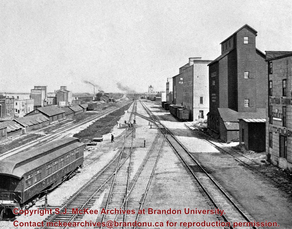
Stuckey's notes: In foreground is publicity coach of Sells-Floto Circus. On left the long row of domestic fuel coal sheds (many of which were later burned), Hanbury's Mill, elevators & Maple Leaf flour mill. On right elevator & Hanbury Hardware (in 1985 used by Christie School Supply).
Scope and Content
Photograph is looking east along the CPR tracks.
Notes
Corresponds with negative 1-2002.3.9.P11.
Repro Restriction
The McKee Archives is the copyright holder for the Stuckey materials.
View is southwest from the John R. Brodie Science Centre. Photograph shows: Flora Cowan Hall, the Brandon University Gymnasium, Darrach Hall, the Quill trailer and the Jeff Umphrey Centre.


.jpg?width=1200&404=no-img.jpg&watermark=wmk)
.jpg?width=180&404=no-img.jpg)
.jpg?width=1200&404=no-img.jpg&watermark=wmk)
.jpg?width=180&404=no-img.jpg)


.jpg%3fmaxheight%3d1000%26maxwidth%3d1000%26watermark%3dwmk&description=Aerial+View+of+Core+Area)
.jpg%3fmaxheight%3d1000%26maxwidth%3d1000%26watermark%3dwmk&description=Aerial+View+of+Core+Area)