Skip header and navigation

Revise Search

20 records – page 7 of 1.

Aerial view: Brandon College campus

http://archives.brandonu.ca/en/permalink/descriptions8055
Part Of
Aerial views and campus photographs
Description Level
Item
GMD
graphic
Date Range
c. 1963
Part Of
Aerial views and campus photographs
Description Level
Item
Series Number
2.1
Item Number
2.1.124
GMD
graphic
Date Range
c. 1963
Physical Description
8" x 10" (b/w)
Physical Condition
A problem during development has obscured a portion of Kinsmen Stadium and the southeast corner of the campus.
Scope and Content
View is north from Victoria Avenue between 18th and 20th Streets to the railway tracks. Photograph shows Kinsmen Stadium, the College campus and a number of residential blocks.
Images
Show Less

Aerial view: Brandon College campus

http://archives.brandonu.ca/en/permalink/descriptions8056
Part Of
Aerial views and campus photographs
Description Level
Item
GMD
graphic
Date Range
c. 1963
Part Of
Aerial views and campus photographs
Description Level
Item
Series Number
2.1
Item Number
2.1.125
GMD
graphic
Date Range
c. 1963
Physical Description
10" x 8" (b/w)
Scope and Content
View is northeast from approximately the southwest corner of Victoria Avenue and 22nd Street to the Assiniboine River near 1st Street. Photograph shows the College campus, Kinsmen Stadium, residential blocks, downtown and the railway tracks.
Images
Show Less

Aerial view: Brandon University campus

http://archives.brandonu.ca/en/permalink/descriptions8057
Part Of
Aerial views and campus photographs
Description Level
Item
GMD
graphic
Date Range
c. 1967
Part Of
Aerial views and campus photographs
Description Level
Item
Series Number
2.1
Item Number
2.1.126
GMD
graphic
Date Range
c. 1967
Physical Description
10" x 8" (colour)
Scope and Content
View is southeast from north of the corner of Princess Avenue and 22nd Street to approximatley Brandon Avenue. Photograph shows the University campus, Kinsmen Stadium, Earl Oxford School, and residential blocks. Brandon Collegiate Institute (BCI) is visible in the upper left corner.
Images
Show Less

Aerial view: Brandon University campus

http://archives.brandonu.ca/en/permalink/descriptions8058
Part Of
Aerial views and campus photographs
Description Level
Item
GMD
graphic
Date Range
c. 1967
Part Of
Aerial views and campus photographs
Description Level
Item
Series Number
2.1
Item Number
2.1.127
GMD
graphic
Date Range
c. 1967
Physical Description
10" x 8" (b/w)
Scope and Content
View is west southwest from approximatley the northside of Princess Avenue just east of 18th Street. Photograph shows the University campus, part of Kinsmen Stadium and residential blocks.
Images
Show Less

Aerial view: Brandon University campus

http://archives.brandonu.ca/en/permalink/descriptions8059
Part Of
Aerial views and campus photographs
Description Level
Item
GMD
graphic
Date Range
c. 1967
Part Of
Aerial views and campus photographs
Description Level
Item
Series Number
2.1
Item Number
2.1.128
GMD
graphic
Date Range
c. 1967
Physical Description
10" x 8" (b/w)
Scope and Content
View is northwest from approximatley the southeast corner of 18th Street and Louise Avenue. Photograph shows the University campus and residential blocks.
Images
Show Less

Aerial view: Brandon University campus

http://archives.brandonu.ca/en/permalink/descriptions8060
Part Of
Aerial views and campus photographs
Description Level
Item
GMD
graphic
Date Range
c. 1978
Part Of
Aerial views and campus photographs
Description Level
Item
Series Number
2.1
Item Number
2.1.129
GMD
graphic
Date Range
c. 1978
Physical Description
10" x 8" (b/w)
Scope and Content
View is southwest from approximatley the corner of 17th Street and Princess Avenue to McDiarmid Drive. Photograph shows the Brandon University campus, Kinsmen Stadium, Fleming School, Coronation Park and residential blocks.
Images
Show Less

Aerial view: Brandon University campus

http://archives.brandonu.ca/en/permalink/descriptions8061
Part Of
Aerial views and campus photographs
Description Level
Item
GMD
graphic
Date Range
c. 1978
Part Of
Aerial views and campus photographs
Description Level
Item
Series Number
2.1
Item Number
2.1.130
GMD
graphic
Date Range
c. 1978
Physical Description
10" x 8" (b/w)
Scope and Content
View is west northwest from aproximatley 15th Street and Louise Avenue to 34th Street. Photograph shows the Brandon University campus, part of Kinsmen Stadium, Fleming School, Coronoation Park, Valleyview Centennial School, Sacred Heart School ?, and residential blocks.
Images
Show Less

Aerial view: Brandon University campus

http://archives.brandonu.ca/en/permalink/descriptions8062
Part Of
Aerial views and campus photographs
Description Level
Item
GMD
graphic
Date Range
c. 1978
Part Of
Aerial views and campus photographs
Description Level
Item
Series Number
2.1
Item Number
2.1.131
GMD
graphic
Date Range
c. 1978
Physical Description
10" x 8" (b/w)
Scope and Content
View is west northwest from aproximatley 16th Street and Louise Avenue to west of 34th Street. Photograph shows the Brandon University campus, part of Kinsmen Stadium, Coronoation Park, Valleyview Centennial School, part of the Assiniboine River and residential blocks.
Images
Show Less

Aerial view: Brandon College campus

http://archives.brandonu.ca/en/permalink/descriptions8063
Part Of
Aerial views and campus photographs
Description Level
Item
GMD
graphic
Date Range
c. 1963
Part Of
Aerial views and campus photographs
Description Level
Item
Series Number
2.1
Item Number
2.1.132
GMD
graphic
Date Range
c. 1963
Physical Description
10" x 8" (b/w)
Scope and Content
View is northwest from the 400 block of 18th Street to the corner of 23rd Street and Rosser Avenue. Photograph shows the Brandon College campus (Flora Cowan Hall under construction) and residential blocks.
Images
Show Less

Aerial view: Brandon University campus

http://archives.brandonu.ca/en/permalink/descriptions8064
Part Of
Brandon University Photograph collection
Description Level
Item
GMD
graphic
Date Range
[1972-1978]
Part Of
Brandon University Photograph collection
Description Level
Item
Series Number
2.1
Item Number
BUPC 2.1.133
GMD
graphic
Date Range
[1972-1978]
Physical Description
10" x 8" (b/w)
Scope and Content
View is southwest from approximatley 16th Street between Lorne Avenue and Princess Avenue. The view extends to approximately 26th Street. Photograph shows the Brandon University campus, Kinsmen Stadium, Fleming School, Coronation Park and residential blocks.
Images
Show Less

Aerial view: Brandon University campus

http://archives.brandonu.ca/en/permalink/descriptions8065
Part Of
Aerial views and campus photographs
Description Level
Item
GMD
graphic
Date Range
c. 1978
Part Of
Aerial views and campus photographs
Description Level
Item
Series Number
2.1
Item Number
2.1.134
GMD
graphic
Date Range
c. 1978
Physical Description
10" x 8" (colour)
Scope and Content
View is southwest from approximatley 16th Street and Princess Avenue to McDiarmid Drive. Photograph shows the Brandon University campus, Kinsmen Stadium, Fleming School, Coronation Park, J.R. Ried School and residential blocks.
Images
Show Less

Aerial view: Brandon College campus

http://archives.brandonu.ca/en/permalink/descriptions8272
Part Of
Aerial views and campus photographs
Description Level
Item
GMD
graphic
Date Range
c. 1964
Part Of
Aerial views and campus photographs
Description Level
Item
Series Number
2.1
Item Number
2.1.1
GMD
graphic
Date Range
c. 1964
Physical Description
4" x 5" (b/w)
Scope and Content
Photograph is looking northwest from approximately the southeast corner of 18th Street and Louise Avenue.
Name Access
Flora Cowan Residence
Subject Access
Aerial views Brandon College
Images
Show Less

Aerial view: Brandon University campus

http://archives.brandonu.ca/en/permalink/descriptions2576
Part Of
Brandon University Photograph Collection
Description Level
Item
GMD
graphic
Date Range
September 21, 1999
Part Of
Brandon University Photograph Collection
Description Level
Item
Series Number
9
Item Number
BUPC 9.36
GMD
graphic
Date Range
September 21, 1999
Physical Description
11" x 14" (colour)
History / Biographical
The photograph was taken for the Centennial of Brandon College/University.
Scope and Content
Aerial photograph taken looking southwest from approximately the northeast corner of Princess Avenue and 17th Street. The entire campus, as well as a number of residential streets are visible.
Notes
Negative is located with the photograph
Subject Access
campus buildings
aerial photographs
aerial photography
aerial views
cityscapes
Storage Range
Oversized drawer 4
Images
Show Less

Aerial view: Brandon University campus

http://archives.brandonu.ca/en/permalink/descriptions2577
Part Of
Brandon University Photograph Collection
Description Level
Item
GMD
graphic
Date Range
September 21, 1999
Part Of
Brandon University Photograph Collection
Creator
Photographer: Aberson Photo
Description Level
Item
Series Number
9
Item Number
BUPC 9.70
GMD
graphic
Date Range
September 21, 1999
Physical Description
16" x 20" (colour)
History / Biographical
The photograph may have been taken for Brandon University's centennial.
Scope and Content
Photograph is looking northeast from approximately Victoria Avenue and 21st Street and shows the Brandon University campus, Kinsmen Stadium, the Assiniboine River and a number of residential neighbourhoods.
Storage Range
Oversize drawer 6
Show Less

Mayor Burgess and Queen Elizabeth

http://archives.brandonu.ca/en/permalink/descriptions14169
Part Of
Fred McGuinness collection
Description Level
Item
GMD
graphic
Date Range
[c.1984]
Accession Number
1-2015
Part Of
Fred McGuinness collection
Description Level
Item
Series Number
McG 9
Item Number
1-2015.238
Accession Number
1-2015
GMD
graphic
Date Range
[c.1984]
Physical Description
10" x 8" (b/w)
Custodial History
Photograph sent to Fred McGuinness from the Winnipeg Free Press Photo Department
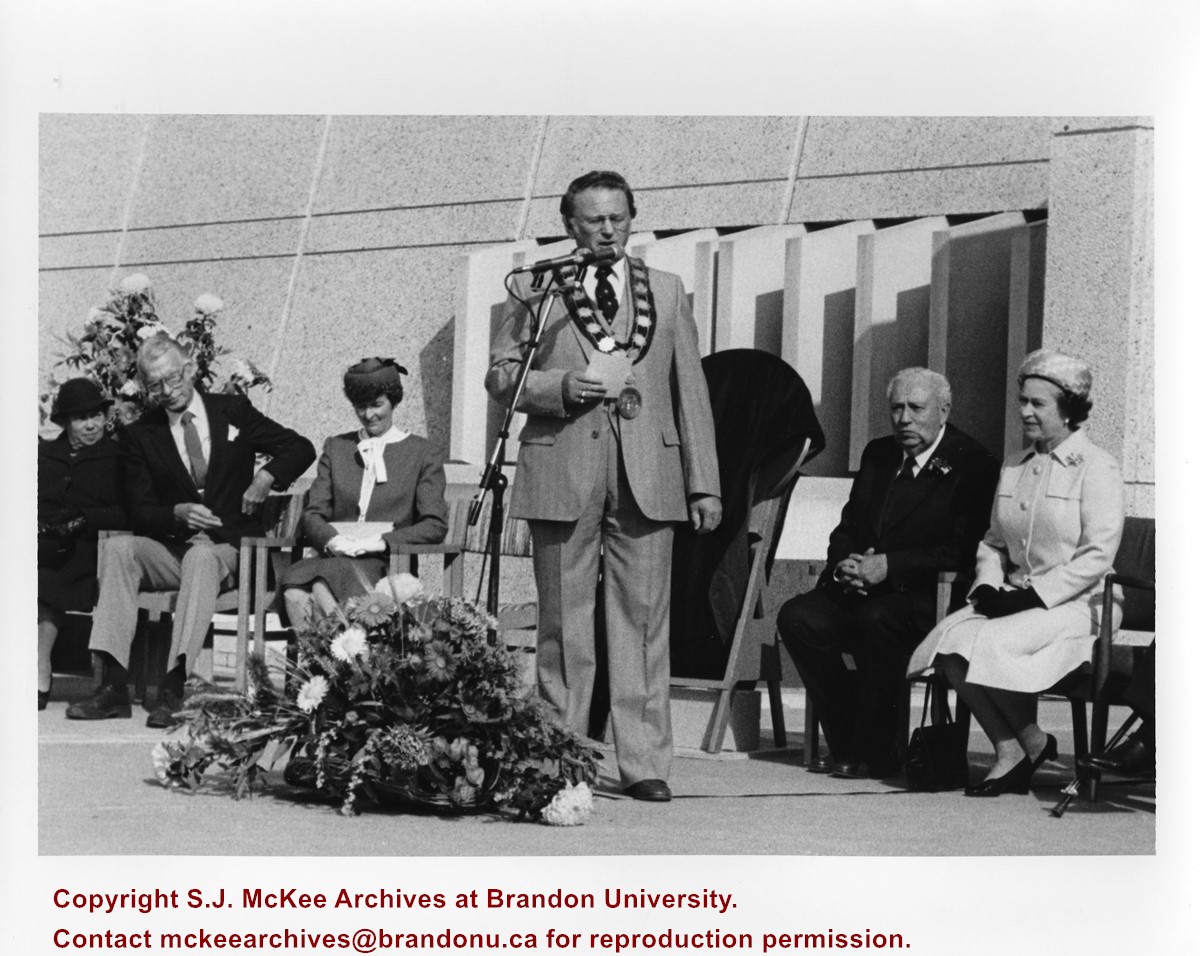
Scope and Content
Photograph shows a platform party in front of the Westman Centennial Auditorium. At the microphone is Mayor Ken Burgess. Seated on the mayor's left is Her Majesty Queen Elizabeth II, to his right Lorne Watson. The party may have been assembled for the founding of the Brandon University School of Music's Queen Elizabeth II building.
Notes
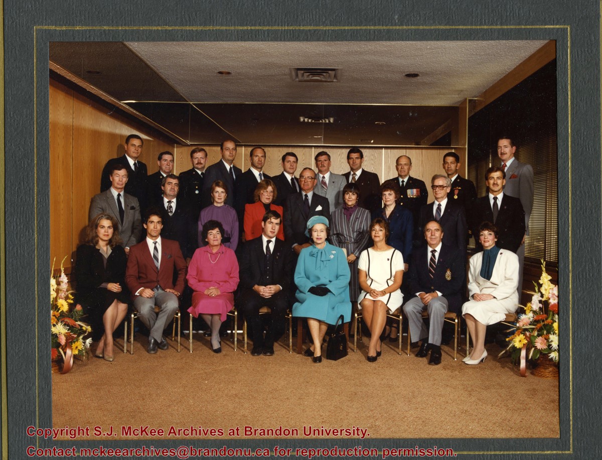
Photograph was collected during the research phase of the monograph "Manitoba: The Province & The People" (1987) written by Fred McGuinness and Ken Coates.
Name Access
Westman Centennial Auditorium
Ken Burgess
Lorne Watson
Queen Elizabeth II
Subject Access
politicians & civil servants
ceremonies
Repro Restriction
Photograph may be subject to Canadian Copy Right Laws.
Storage Location
RG 5 photograph storage drawer 2 (hanging photos)
Arrangement
McG 5.4 File 2
Images
Show Less

Fred McGuinness with Queen Elizabeth II

http://archives.brandonu.ca/en/permalink/descriptions13899
Part Of
Fred McGuinness collection
Description Level
Item
GMD
graphic
Date Range
1984
Accession Number
20-2009
Part Of
Fred McGuinness collection
Creator
Photographer: Towne Studios
Description Level
Item
Series Number
McG 9
Item Number
20-2009.210
Accession Number
20-2009
GMD
graphic
Date Range
1984
Physical Description
3" x 4" (colour)
Scope and Content
Photograph shows a group of individuals posing with Queen Elizabeth II. Fred McGuinness is standing behind the Queen.
Notes
Behind the photograph is a letter dated 15 November 1984 to Fred McGuinness, Brandon, Manitoba, from Michael B. Decter, Clerk of the Executive Council, Cabinet Secretary, re: Her Majesty's Visit to Manitoba
Name Access
Fred McGuinness
Queen Elizabeth II
Subject Access
portraits
Storage Location
McGuinness oversize storage drawer (1-2015)
Arrangement
From 20-2009 #4 plastic envelope #1
Images
Show Less

Aerial view: Brandon University campus covered in snow

http://archives.brandonu.ca/en/permalink/descriptions613
Part Of
Aerial views and campus photographs
Description Level
Item
GMD
graphic
Date Range
c. 1970s
Part Of
Aerial views and campus photographs
Description Level
Item
Series Number
2.1
Item Number
2.1.22
GMD
graphic
Date Range
c. 1970s
Physical Description
5" x 3.5" (b/w)
Physical Condition
Photograph is slightly overexposed.
Scope and Content
View is north northwest from the John R. Brodie Science Center (?). Photograph shows: Citizens' Science Building, Brandon College Building and Clark Hall, the Education Building and the driveway running in front of the buildings.
Images
Show Less

Aerial view: Brandon College campus from north

http://archives.brandonu.ca/en/permalink/descriptions615
Part Of
Aerial views and campus photographs
Description Level
Item
GMD
graphic
Date Range
c. 1963
Part Of
Aerial views and campus photographs
Description Level
Item
Series Number
2.1
Item Number
2.1.23
GMD
graphic
Date Range
c. 1963
Physical Description
5" x 4" (b/w)
Scope and Content
View is north, taken from approximatley 19th Street and Rosser Avenue. Photograph shows: Clark Hall, the A.E. McKenzie Building, the J.R.C. Evans Lecture Theatre, H-Huts, Darrach Hall and Flora Cowan Hall, as well as a number of homes in the area.
Images
Show Less

Aerial view: Brandon College campus looking northwest

http://archives.brandonu.ca/en/permalink/descriptions616
Part Of
Aerial views and campus photographs
Description Level
Item
GMD
graphic
Date Range
c. 1963
Part Of
Aerial views and campus photographs
Description Level
Item
Series Number
2.1
Item Number
2.1.24
GMD
graphic
Date Range
c. 1963
Physical Description
5" x 4" (b/w)
Scope and Content
View is northwest from approximately the corner of 18th Street and Louise Avenue. Photograph shows the Brandon College campus after the completion of Flora Cowan Hall.
Notes
BUPC 2.1.20 is a larger version of this photograph.
Images
Show Less

Aerial view: Brandon College campus and Kinsmen Park

http://archives.brandonu.ca/en/permalink/descriptions621
Part Of
Aerial views and campus photographs
Description Level
Item
GMD
graphic
Date Range
c. 1962
Part Of
Aerial views and campus photographs
Description Level
Item
Series Number
2.1
Item Number
2.1.19
GMD
graphic
Date Range
c. 1962
Physical Description
10" x 8" (b/w)
Physical Condition
The bottom right hand corner has been torn off. Both portions of the photograph are stored together.
Scope and Content
View is northwest from approximately 17th Street and Victoria Avenue. Photograph shows: the Brandon College campus and the Kinsmen Park and baseball diamond. Taken during construction of Flora Cowan Hall but before the Gymnasium was built.
Images
Show Less

20 records – page 7 of 1.