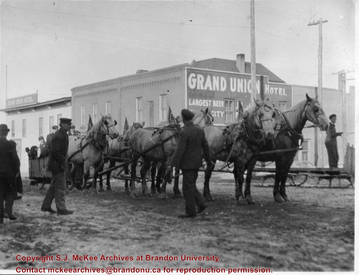
The amateur's kitchen garden, frame-ground and forcing pit : a handy guide to the formation and management of the kitchen garden and the cultivation of useful vegetables and fruits
Donated to Fred McGuinness by Mrs. Marian Gray of Brandon, September 13, 1978.
Scope and Content
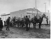
Postcard shows the West End Park (also known as Stanley Park) and Park School. The school was situated on the southwest corner of Lorne Avenue. A couple of residences surround the school. Walking paths, a park bench, and a gazebo/grandstand can be seen in the park.
Notes
Front of postcard reads: Published for Christie's Book Store, Brandon, Man., 6350. Back of postcard reads: Canadian Souvenir Post Card, Warwick Brothers & Rutter, Limited, Printers, Toronto. The postcard is addressed to Miss Isabella Heastwell of Broderick, Saskatchewan, and is dated July 14, 1910.
Joseph Donaldson's Ltd. Food Market appears in the Henderson's Brandon City Directory from 1906 to 1929. Donaldson's main meat/butcher shop was located at 813 Rosser Avenue. A second branch was opened by 1914 at 228 Rosser Avenue but relocated to 654 Tenth Street by 1917. The branch relocated by 1921 to 662 Tenth Street where it remained until ca.1929. This address was referred to as the "Busy Corner" in the Henderson's Directory. In 1931, butcher Ted Hill appears to have taken over the Donaldson's establishments.
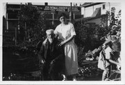
Scope and Content
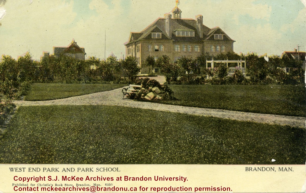
Photograph shows George Pope sitting in a backyard. Standing next to him is Isabella Louise McGuinness (Pope). A young girl, perhaps Ruth McGuinness, is standing over a stroller. A wood pile and garden plants can be seen in the backyard. An advertisement for Joseph Donaldson's Ltd Food Markets can be seen on a business beside the residence.
Notes
Writing on the back of the photograph reads: This is mum her uncle George Pope who came to Brandon in 1880 (I think) in the back yard of 708-10th Street. It looked like Ruth in the lower right corner. I was interested in the Donaldson advertising.
For custodial history see the collection level description of the Lawrence Stuckey collection.
Scope and Content
Stanley Park from old PC.
Notes
Shows bandstand
[By "PC" Mr. Stuckey likely meant to indicate Park School (built 1904, demolished 1978). Park School was, at the time the photo was taken, located directly across Lorne Avenue from Stanley Park. P.E. 22/07/09]
This wedge-shaped tract of woodland was located west of 34th Street on the south side of the Canadian Pacific Railway. It was formerly owned by the Great Northern Railway, and was acquired by the CPR when the GN line was abandoned in 1936. In 1978 Marathon Realty (CPR) sold this 7 acre property to a developer who planned to build condominiums. However this residential development was objected to for two reasons: [The proposed location] was home to many species of flora & fauna, and it was too close to the CPR mainline. Local residents took out a petition against the development. [Mr. Stuckey] wrote a letter to the editor of the Brandon Sun, [expressing the] attitudes of CPR officials, and read a statement to the Provincial Planning Board suggesting development be refused and the area become an undeveloped park. These efforts would prove successful - see file on same.
Custodial History
For custodial history see the collection level description of the Lawrence Stuckey collection.
Scope and Content
John Indian's Bush (also known as Bang's Bush)
Notes
Additional historical information provided by the Fred McGuinness collection (20-2009). Stuckey's letter to the editor appears in the July 22, 1978 issue of The Brandon Sun.
This wedge-shaped tract of woodland was located west of 34th Street on the south side of the Canadian Pacific Railway. It was formerly owned by the Great Northern Railway, and was acquired by the CPR when the GN line was abandoned in 1936. In 1978 Marathon Realty (CPR) sold this 7 acre property to a developer who planned to build condominiums. However this residential development was objected to for two reasons: [The proposed location] was home to many species of flora & fauna, and it was too close to the CPR mainline. Local residents took out a petition against the development. [Mr. Stuckey] wrote a letter to the editor of the Brandon Sun, [expressed the] attitudes of CPR officials, and read a statement to the provincial planning board suggesting development be refused and the area become an undeveloped park. These efforts would prove successful - see file on same.
Custodial History
For custodial history see the collection level description of the Lawrence Stuckey collection.
Scope and Content
John Indian's Bush (also known as Bang's Bush).
Notes
Additional historical information provided by the Fred McGuinness collection (20-2009). Stuckey's letter to the editor appears in the July 22, 1978 issue of The Brandon Sun.
Peace Garden. Student activity: International Relations Conference. study group L-R Mellanie Berthume (?), Marion McGregor (?), ?, Dave Halstead, ?, Nora Malyn (centre at head of the table)
According to Russ Gourluck (Silver Screens on the Prairie, Winnipeg: Great Plains Publications, 2012, 26), the Orpheum Theatre was in operation from 1917 to 1920 when it then became the Willis Theatre.
Scope and Content
Postcard shows the 100 block of 10th Street facing north. The CPR train station can be seen at the end of 10th Street. The sign for the Rex Cafe is visible on the west side of 10th Street. On the east side of 10th Street, billboards for Campbell & Campbell furniture are visible as well as signs for Pianos and the Orpheum Theatre. Motorists and cyclists share the road. Street car tracks run the length of 10th Street.
Notes
Postcard was manufactured by T.B. [Tichnor Brothers, Inc., 1908-1987] Cambridge, Massachusetts.
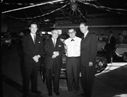
faculty activity (science) - opening of the observatory-women's auxiliary presenting cheque. L to R-Helen, Wes Wong, Don Mackay, ?, Lloyd Dulmage, Wesley Wong
Opening of the observatory-receiving of donation from women's auxiliary. L to R Back- D. R. MacKay, ?, Wes Wong, Gwen (Mrs. D. R.) MacKay, Lloyd Dulmage; Front-Helen Wong, Mrs. J. Hardy, Bernice (Mrs. Lloyd) Dulmage, Billie (Mrs. Gordon) McPherson, Charlotte (Mrs. Cliff) Carbano
Faculty activity (science) opening of the Observatory. L to R- D. R. Mackay, Helen Wong, Bernice Dulmage, Charlotte Carbano, Billie McPherson ?, Hardy, ?, Gwen MacKay, ?, Wesley Wong; Foreground-Lloyd Dulmage
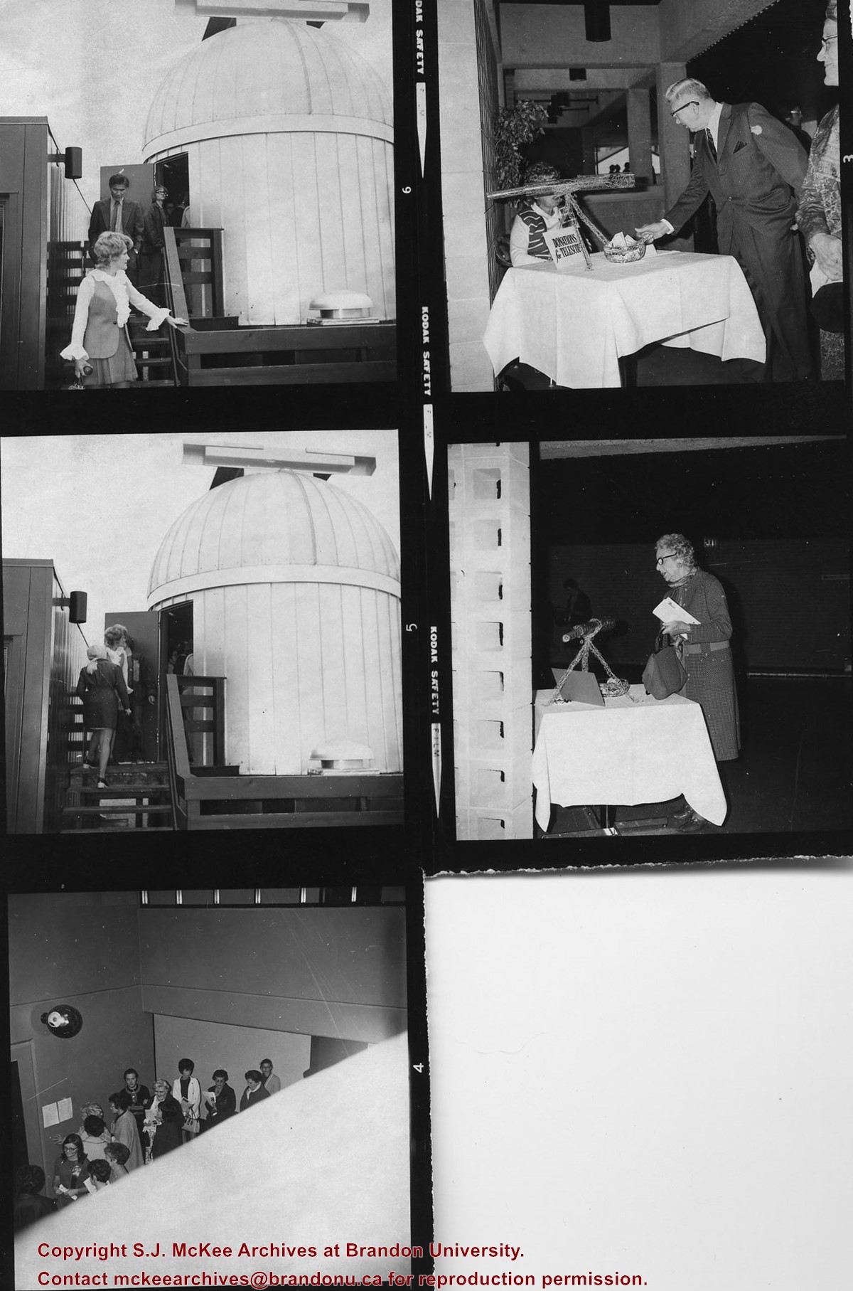
The Observatory is located on the roof of McMaster Hall.
Scope and Content
Item is five contact prints taken at the opening of the Observatory.
Print 1: Steps to the Observatory (man on the steps is Westly Wong)
Print 2: Steps to the Observatory
Print 3: Visitors
Print 4: Foyer of McMaster Hall (Prof. R.M. Simmons making a donation towards a telescope)
Print 5: Foyer of McMaster Hall (female visitor)
Photograph shows the 700-block of Rosser Avenue facing west. Visible businesses on the north side of Rosser Avenue include: Burchill's Music Store, E.W. Woolworth Co. Ltd. 5-10 and 15 Cent Store in the E.E. Evans Block, Empire Hotel, and W.A. Paterson Drugs. Automobiles are parked on both sides of the avenue and at the time the photograph was taken, Rosser Avenue was a two-way street.
Notes
Part of "Souvenir of Brandon, Manitoba, Canada [viewbook], Printed by Photogelatine Engraving Co. Limited, Ottawa." Dates obtained from the Burchill's Music Store Henderson's Brandon City Directory listings (1927-1929). Writing on the front of the photograph reads: Rosser St. [sic.] - Brandon, Man.


.jpg?width=1200&404=no-img.jpg&watermark=wmk)
.jpg?width=180&404=no-img.jpg)
.jpg?width=1200&404=no-img.jpg&watermark=wmk)
.jpg?width=180&404=no-img.jpg)


.jpg%3fmaxheight%3d1000%26maxwidth%3d1000%26watermark%3dwmk&description=John+Indian%27s+Bush)
.jpg%3fmaxheight%3d1000%26maxwidth%3d1000%26watermark%3dwmk&description=John+Indian%27s+Bush)