Photograph shows the northeast corner of 10th Street and Princess Avenue. OK Used Cars - Western Motors Ltds - used car lot and a building containing The Specialty Shop and another business are pictured. The exposed wall of the Brown Block has been painted over.
This negative provides an excellent view of Rosser Avenue (looking east from 10th Street) in the early 20th century, and shows one of the first runs for Brandon's streetcar system.
This image was used as the cover image for Lee Clark's Brandon's Politics & Politicians.
Custodial History
For custodial history see the collection level description of the Lawrence Stuckey collection.
Photograph of west side of 10th Street, Brandon, Manitoba, facing northwest. Visible businesses in the Alexandra Block include Doig's, Box Brothers Hardware and Allied Hardware Stores, followed by Simpsons-Sears and Barry Neill Men's Wear in the Strathcona Block. The Johnny Smith Block is visible in the background.
Photograph of 10th Street facing north from Princess Avenue. Vehicles are parallel parked on both sides of the street. The Welcome Brandon sign can be seen at the Rosser Avenue intersection.
Visible businesses on the west side of 10th Street include: Doig's, Box Brothers Hardware and Allied Hardware Stores in the Alexandra Block; followed by Simpsons-Sears in the Strathcona Block. Barry Neill Men's Wear, Kresge's and the Cecil Hotel are also visible. The Johnny Smith Block is visible in the background.
Visible businesses on the east side of 10th Street include: Ollies Steaks and Chops, Elna Sewing Centre, Carlton Cafe, Chop Suey. At the base of the hill the Canadian Pacific train station is visible at the base of the hill.
Notes
Writing on the front of the postcard reads: Tenth St. Brandon, Man.
Photograph shows Princess Avenue facing east from 10th Street. On the north side of Princess Avenue, a B/A Service Station, Princess Cafe, Lindenberg Seeds, and the Central Fire Station are visible. Old City Hall with the war memorial and the Prince Edward Hotel are visible on the south side of Princess Avenue. Traffic is travelling one-way on Princess Avenue.
Red ink stain is on the front right corner of postcard
Scope and Content
Photograph shows 10th Street facing south from Princess Avenue. Visible landmarks and businesses include: Manitoba Power Commission (MPC)'s power sub-station, First Baptist Church, Wheat City Arena, and the grand stand at the Exhibition Grounds.
The partial sign visible at the bottom of the photograph on the east side of 10th Street reads Yates and Neale, which refers to a plumbing and heating company that dissolved in 1943 to be replaced by Neale, Stothard and Chapman.
Businesses on the west side of 10th Street include: Dominion Tire & Radio Co., Bolts Barber Shop, Elviss T.E. Co. Stables.
Notes
Information concerning Yates and Neale courtesy Jack Stothard. Writing on the front of the postcard reads: Brandon, Looking S.W., Jerrett Photo. This photograph shows a rare view of the 200-block of 10th Street.
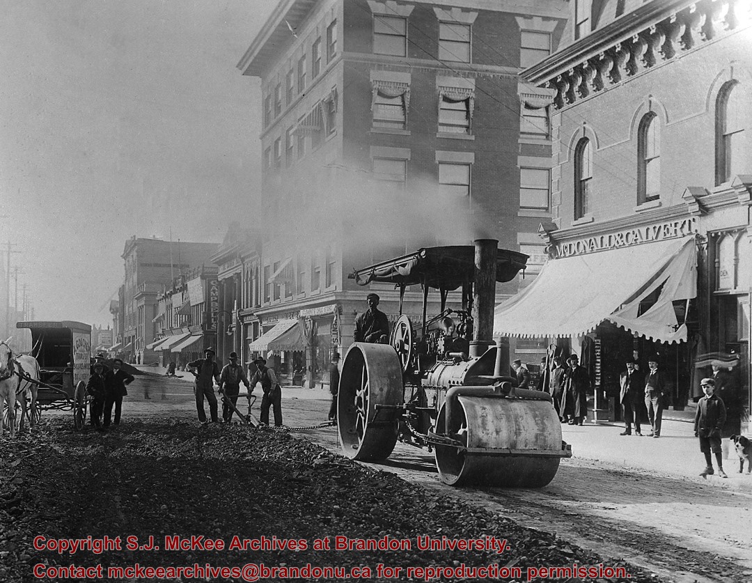
Photograph shows the southeast corner of 10th Street and Rosser Avenue, Brandon, Manitoba. The Bank of Montreal is situated on the corner. Visible businesses along the east side of 10th Street include: Barclay's Shoe Store, Carlton Cafe, and Ted Heming Jewellers.
Photographs have been glued to a backing board that has warped over time
Scope and Content
Photograph shows street view of north side of Rosser Avenue, primarily the 700 block. Horse and buggies are travelling on the avenue and pedestrians fill the sidewalks. Union Jacks and English flags are mounted from the windows on the Fleming and Beaubier blocks. Flag banners are drapped across Rosser Avenue. Businesses visible in the Fleming Block include: Lowes Brothers Clothing and Spring Park Nurseries. Businesses visible in the Beaubier Block include the Empire Hotel. Businesses east of the Empire Hotel are grocer A.M. Percival and the Brandon Hardware Company. An advertisement for the Northern Bank is affixed to a telephone pole on the southside of the street.
Notes
Writing on the front of the photograph matting reads: July 1 1906, 314. One photograph (20-2009.8) is glued below and another, 20-2009.6, is glued on the reverse side. Page appears to be from a photo album.
Photographs have been glued to a backing board that has warped over time
Scope and Content
Photograph shows street view of north side of Rosser Avenue, primarily the 700 block. Horse and buggies are travelling on the avenue and pedestrians fill the sidewalks. Union Jacks and English flags are mounted from the windows on the Fleming and Beaubier blocks. Flag banners are drapped across Rosser Avenue. Businesses visible in the Fleming Block include: Lowes Brothers Clothing and Spring Park Nurseries. Businesses visible in the Beaubier Block include the Empire Hotel. Businesses east of the Empire Hotel are grocer A.M. Percival and the Brandon Hardware Company. An advertisement for the Northern Bank is affixed to a telephone pole on the southside of the street. The street is lined with litter and a number of dogs can be seen roaming the area.
Notes
Writing on the front of the photograph matting reads: 313 July 1906. One photograph (20-2009.8) is glued below and another, 20-2009.6, is glued on the reverse side. Page appears to be from a photo album.
Photographs have been glued to a backing board that has warped over time
History / Biographical
Photograph of possible Dakota from Sioux Valley in Brandon for the summer fair.
Scope and Content
Photograph shows street view of north side of Rosser Avenue, primarily the 700 block. Businesses visible in the Fleming Block include: Lowes Brothers Clothing, Robert Hall [Insurance Broker], Manitoba Farmers Hedge and Wire Fence Company. Businesses visible in the Beaubier Block include the Empire Hotel. Businesses east of the Empire Hotel are grocer A.M. Percival and the Brandon Hardware Company. A number of Aboriginal peoples are travelling on horseback west along Rosser Avenue as spectators look on.
Notes
Writing on the front of the photograph matting reads: 293. One photograph (20-2009.9) is glued above and two others are glued on the reverse side. Page appears to be from a photo album.
Photograph shows the 700-block of Rosser Avenue facing west. Visible businesses on the north side of Rosser Avenue include: Burchill's Music Store, E.W. Woolworth Co. Ltd. 5-10 and 15 Cent Store in the E.E. Evans Block, Empire Hotel, and W.A. Paterson Drugs. Automobiles are parked on both sides of the avenue and at the time the photograph was taken, Rosser Avenue was a two-way street.
Notes
Part of "Souvenir of Brandon, Manitoba, Canada [viewbook], Printed by Photogelatine Engraving Co. Limited, Ottawa." Dates obtained from the Burchill's Music Store Henderson's Brandon City Directory listings (1927-1929). Writing on the front of the photograph reads: Rosser St. [sic.] - Brandon, Man.
Photograph is looking north northeast and shows the Brandon Public Library, Smith's Tobacco Shop, Smith's Hairstyling for Men, Brandon Jewellers, and the Chrest Block, including Chrest Dry Cleaners.
Repro Restriction
The McKee Archives is the copyright holder for the Stuckey materials.
Photograph is looking north northeast from 11th Street and shows the Brandon Public Library, Smith's Tobacco Shop, Smith's Hairstyling for Men, Brandon Jewellers, the Chrest Block, including Chrest Dry Cleaners, Canadian Acceptance, Breslauer & Warren, Scotia Towers and the parking lot on the southside of the block.
Repro Restriction
The McKee Archives is the copyright holder for the Stuckey materials.
For custodial history see the collection level description of the Lawrence Stuckey collection.
Scope and Content
900 block of Rosser Avenue
Notes
T.D. McLean - jeweller & watchmaker; Imperial Bank of Canada; The New Era - real estate; Fortier & Bucke - Manufacturers' Agents/Canada Pacific Express Co.
The Strome & White Co. General Store (L. foreground; built 1902) became Brandon Hardware & Brandon Hardware block, later Ashdowns; The final tenant was Stylerite Hardware with two floors of residential suites. It was destroyed by fire March 27, 1983
Custodial History
For custodial history see the collection level description of the Lawrence Stuckey collection.
Scope and Content
View of Rosser Avenue, looking east from Seventh Street


.jpg?width=1200&404=no-img.jpg&watermark=wmk)
.jpg?width=180&404=no-img.jpg)
.jpg?width=1200&404=no-img.jpg&watermark=wmk)
.jpg?width=180&404=no-img.jpg)


.jpg%3fmaxheight%3d1000%26maxwidth%3d1000%26watermark%3dwmk&description=1000+block+rosser+avenue)
.jpg%3fmaxheight%3d1000%26maxwidth%3d1000%26watermark%3dwmk&description=1000+block+rosser+avenue)