S. J. McKee Archives

10th Street from Princess Avenue facing north, Brandon, Manitoba

http://archives.brandonu.ca/en/permalink/descriptions8402
Part Of
Joseph H. Hughes collection
Description Level
Item
GMD
graphic
Date Range
c. 1955
Accession Number
3-1997
Part Of
Joseph H. Hughes collection
Creator
Photographer: Jerrett Photo
Description Level
Item
Series Number
3-1997.1
Item Number
3-1997.1.24
Accession Number
3-1997
GMD
graphic
Date Range
c. 1955
Physical Description
3.5" x 5.5" (b/w)
Material Details
postcard
Physical Condition
good
Scope and Content
Photograph of 10th Street facing north from Princess Avenue. Vehicles are parallel parked on both sides of the street. The Welcome Brandon sign can be seen at the Rosser Avenue intersection. Visible businesses on the west side of 10th Street include: Doig's, Box Brothers Hardware and Allied Hardware Stores in the Alexandra Block; followed by Simpsons-Sears in the Strathcona Block. Barry Neill Men's Wear, Kresge's and the Cecil Hotel are also visible. The Johnny Smith Block is visible in the background. Visible businesses on the east side of 10th Street include: Ollies Steaks and Chops, Elna Sewing Centre, Carlton Cafe, Chop Suey. At the base of the hill the Canadian Pacific train station is visible at the base of the hill.
Notes
Writing on the front of the postcard reads: Tenth St. Brandon, Man.
Name Access
Strathcona Block
Alexandra Block
Doig's
Box Brothers Hardware
Simpsons-Sears Ltd.
Barry Neill Men's Wear
Kresge
Cecil Hotel
CPR Station
Ollies
Elna Sewing Centre
Carlton Cafe
10th Street
Subject Access
downtowns
street scenes
Brandon business buildings & facilities after 1940
building exteriors
Chinese restaurants
Storage Location
RG 5 photograph storage drawer
Images
Show Less

Princess Avenue facing east from 10th Street, Brandon, Manitoba

http://archives.brandonu.ca/en/permalink/descriptions8413
Part Of
Joseph H. Hughes collection
Description Level
Item
GMD
graphic
Date Range
c. 1965
Accession Number
3-1997
Part Of
Joseph H. Hughes collection
Description Level
Item
Series Number
3-1997.1
Item Number
3-1997.1.35
Accession Number
3-1997
GMD
graphic
Date Range
c. 1965
Physical Description
10" x 8" (b/w)
Physical Condition
good
Scope and Content
Photograph shows Princess Avenue facing east from 10th Street. On the north side of Princess Avenue, a B/A Service Station, Princess Cafe, Lindenberg Seeds, and the Central Fire Station are visible. Old City Hall with the war memorial and the Prince Edward Hotel are visible on the south side of Princess Avenue. Traffic is travelling one-way on Princess Avenue.
Name Access
Princess Avenue
City Hall
Prince Edward Hotel
B/A Service Station
Princess Cafe
Lindenberg Seeds
Central Fire Station
Subject Access
downtowns
street scenes
Brandon business buildings & facilities after 1940
building exteriors
hotels
garages
service stations
cafes
memorials
Storage Location
RG 5 photograph storage drawer
Images
Show Less

Corner of 10th street and Rosser avenue

http://archives.brandonu.ca/en/permalink/descriptions6449
Part Of
Alf Fowler collection
Description Level
Item
GMD
graphic
Date Range
ca. 1911
Accession Number
6-1999
Part Of
Alf Fowler collection
Creator
Davidson & Gowen
Description Level
Item
Item Number
6-1999.24
Accession Number
6-1999
GMD
graphic
Date Range
ca. 1911
Physical Description
9.25" x 7" (b/w)
Custodial History
See fonds level description of the Alf Fowler collection for custodial history.
Scope and Content
Photo shows the the corner of 10th Street and Rosser Avenue, looking northwest. Visible businesses include: the Canadian Bank of Commerce; The Sun; Canadian Pacific; Brandon Brick Co.; T. Bronson; Fraser and Co.; and the John E. Smith Block.
Storage Range
RG 5 Western Manitoba Manuscript collection - photograph storage drawer
Images
Show Less

Princess avenue and 10th street intersection

http://archives.brandonu.ca/en/permalink/descriptions8670
Part Of
RG 11 Lawrence Stuckey fonds
Description Level
Item
GMD
graphic
Date Range
c. 1970
Accession Number
1-2002
Part Of
RG 11 Lawrence Stuckey fonds
Creator
Lawrence Stuckey
Description Level
Item
Series Number
3.9
Item Number
1-2002.3.9.48
Accession Number
1-2002
GMD
graphic
Date Range
c. 1970
Physical Description
4.5" x 3.25" (b/w)
Scope and Content
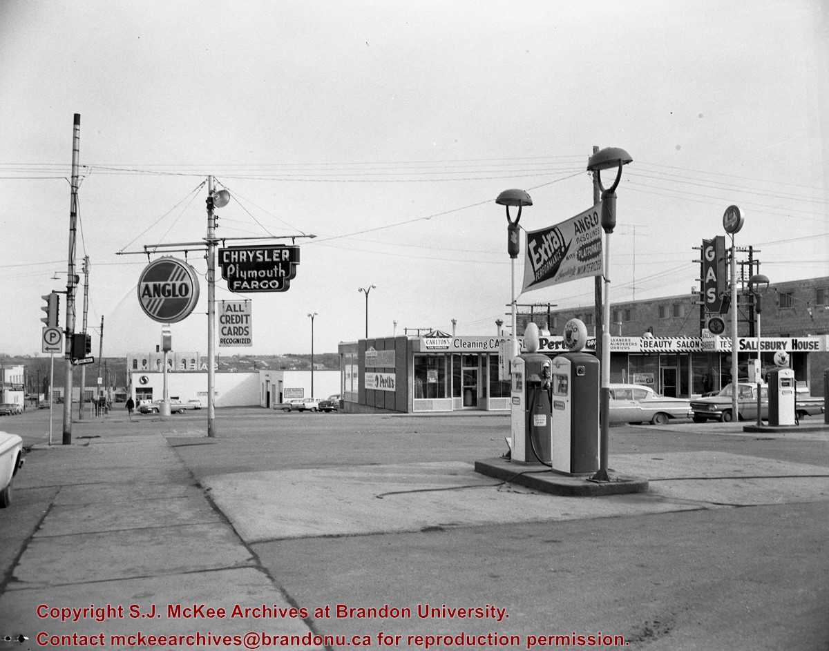
Photograph is looking east northeast from the southwest corner of the intersection. Visible are: Brandon Hotel, public parking lot and a service station.
Repro Restriction
The McKee Archives is the copyright holder for the Stuckey materials.
Storage Location
RG 5 photograph storage drawer
Images
Show Less

Southwest corner 10th Street and Rosser Avenue

http://archives.brandonu.ca/en/permalink/descriptions8409
Part Of
Joseph H. Hughes collection
Description Level
Item
GMD
graphic
Date Range
c. 1950
Accession Number
3-1997
Part Of
Joseph H. Hughes collection
Description Level
Item
Series Number
3-1997.1
Item Number
3-1997.1.31
Accession Number
3-1997
GMD
graphic
Date Range
c. 1950
Physical Description
10" x 8" (b/w)
Physical Condition
good
Scope and Content
Photograph shows the Kresge store on the southwest corner of 10th Street and Rosser Avenue. Other 10th Street businesses that are visible on the west side of the street include: James Richardson & Son Investments, Beneficial Finance and Loans, Bass' Storkland, Brandon News & Record Shop, Recreation Bowling and Billiards, and Bottomley's. The Welcome Brandon sign can be seen in the top right corner of the photograph.
Name Access
10th Street
Kresge
James Richardson & Sons
Beneficial Finance Co.
Bass Storkland
Brandon News & Record Shop
Recreation Bowling and Billiards
Bottomley's
Subject Access
downtowns
street scenes
Brandon business buildings & facilities after 1940
building exteriors
Storage Location
RG 5 photograph storage drawer
Images
Show Less

East side 10th Street facing north from Princess Avenue, Brandon, Manitoba

http://archives.brandonu.ca/en/permalink/descriptions8376
Part Of
Joseph H. Hughes collection
Description Level
Item
GMD
graphic
Date Range
1962
Accession Number
3-1997
Part Of
Joseph H. Hughes collection
Description Level
Item
Series Number
3-1997.1
Item Number
3-1997.1.6
Accession Number
3-1997
GMD
graphic
Date Range
1962
Physical Description
8"x 10" (b/w)
Physical Condition
good
Scope and Content
Photograph of an east side of 10th Street facing north from Princess Avenue. Visible businesses include: Thunderbird Bowl, Canadian Pacific Telegraphs, Pittsburgh Paint & Glass, Strand Theatre, Trans Canada Credit Loans, Ted Heming Jewellers, Carlton Cafe, McKenzie Seeds, Clement Block, Mitrou's Cafe and Tea Room, and Brandon Musical Supply Ltd. Vehicles parked on 10th Street are facing north.
Notes
Photograph dated from "Tara's Bulba," the movie playing at the Strand Theatre and similiar vehicles captured in the photograph.
Name Access
Thunderbird Bowl
Canadian Pacific Telegraphs
Pittsburgh Paint & Glass
Strand Theatre
Trans Canada Credit Loans
Ted Heming Jewellers
Carlton Cafe
McKenzie Seeds
Clement Block
Mitrou Building
Brandon Musical Supply Ltd.
10th Street
Subject Access
downtowns
street scenes
Brandon business buildings & facilities after 1940
Storage Location
RG 5 photograph storage drawer
Images
Show Less

West side of 10th Street facing north from Princess Avenue, Brandon, Manitoba

http://archives.brandonu.ca/en/permalink/descriptions8385
Part Of
Joseph H. Hughes collection
Description Level
Item
GMD
graphic
Date Range
c. 1959
Accession Number
3-1997
Part Of
Joseph H. Hughes collection
Description Level
Item
Series Number
3-1997.1
Item Number
3-1997.1.13
Accession Number
3-1997
GMD
graphic
Date Range
c. 1959
Physical Description
8" x 10" (b/w)
Physical Condition
good
History / Biographical
Doig's, originally located on Rosser Avenue, moved to the 10th Street location in 1921.
Scope and Content
Photograph of west side of 10th Street, Brandon, Manitoba, facing northwest. Visible businesses in the Alexander Block include Doig's, Box Brothers Hardware and Allied Hardware Stores, followed by Simpsons-Sears and Barry Neill Men's Wear in the Strathcona Block. The Johnny Smith Block is visible in the background.
Name Access
Strathcona Block
Alexandra Block
Doig's
Box Brothers Hardware
Simpsons-Sears Ltd.
Barry Neill Men's Wear
10th Street
Subject Access
downtowns
street scenes
Brandon business buildings & facilities after 1940
building exteriors
Storage Location
RG 5 photograph storage drawer
Images
Show Less

West side 200-block 10th Street, south of Princess Avenue, Brandon, Manitoba

http://archives.brandonu.ca/en/permalink/descriptions8416
Part Of
Joseph H. Hughes collection
Description Level
Item
GMD
graphic
Date Range
c. 1955
Accession Number
3-1997
Part Of
Joseph H. Hughes collection
Description Level
Item
Series Number
3-1997.1
Item Number
3-1997.1.38
Accession Number
3-1997
GMD
graphic
Date Range
c. 1955
Physical Description
10" x 8" (b/w)
Physical Condition
good
Scope and Content
Photograph shows the west side of the 200-block on 10th Street. Visible businesses include: Chamber of Commerce Tourist Information, Dominion Tire & Radio Co., Bonnie's Bonnet Shop, Steve's Grill, Wally's Taxi, and Western Motors Ltd. The painted advertisement for Doig, Rankin and Robertson is visible on the Alexandra Block. Christmas ornaments are displayed from light standards and include Santa Claus and a Christmas elf.
Name Access
Chamber of Commerce
Dominion Tire & Radio Co.
Bonnie's Bonnet Shop
Steve's Grill
Wally's Taxi
Western Motors
10th Street
Subject Access
downtowns
street scenes
Brandon business buildings & facilities after 1940
building exteriors
winter
garages
taxi
restaurants
Christmas
Storage Location
RG 5 photograph storage drawer
Images
Show Less

Brandon streets - Princess Avenue looking east from 10th Street

http://archives.brandonu.ca/en/permalink/descriptions11556
Part Of
CKX fonds
Description Level
Item
GMD
graphic
Date Range
after 1954
Accession Number
11-2010
Part Of
CKX fonds
Creator
CKX
Description Level
Item
Item Number
11-2010.B103e
Accession Number
11-2010
GMD
graphic
Date Range
after 1954
Physical Description
5" x 4" (b/w)
Material Details
Negative
Custodial History
See fonds level of the CKX records for custodial history.
Scope and Content
Image of Princess Avenue looking east from 10th Street.
Name Access
CKX
Brandon, Manitoba
Subject Access
steetscapes
Storage Location
CKX fonds - 2010 accessions
Images
Show Less

Brandon streets - 10th Street looking north from Princess Avenue

http://archives.brandonu.ca/en/permalink/descriptions11558
Part Of
CKX fonds
Description Level
Item
GMD
graphic
Date Range
after 1954
Accession Number
11-2010
Part Of
CKX fonds
Creator
CKX
Description Level
Item
Item Number
11-2010.B103g
Accession Number
11-2010
GMD
graphic
Date Range
after 1954
Physical Description
5" x 4" (b/w)
Material Details
Negative
Custodial History
See fonds level of the CKX records for custodial history.
Scope and Content
Image of 10th Street looking north from Princess Avenue.
Name Access
CKX
Brandon, Manitoba
Subject Access
steetscapes
Storage Location
CKX fonds - 2010 accessions
Images
Show Less

Queen's Hotel on the corner of 10th Street and Rosser Avenue

http://archives.brandonu.ca/en/permalink/descriptions13778
Part Of
Fred McGuinness collection
Description Level
Item
GMD
graphic
Date Range
1883
Accession Number
20-2009
Part Of
Fred McGuinness collection
Description Level
Item
Series Number
McG 9
Item Number
20-2009.89
Accession Number
20-2009
GMD
graphic
Date Range
1883
Physical Description
7.25" x 4.25" (b/w)
Material Details
on matting
Physical Condition
Left hand corner of mat is bent. Mock-up instructions are written in pencil at the bottom right hand corner. Portions of the photograph itself are marked with pen.
History / Biographical
The Queen's Hotel was located on the corner of Rosser Avenue and Tenth Street (Steen & Boyce, 1882. Brandon, Manitoba, Canada and Her Industries. Steen & Boyce Publishers Printers & Binders, 81.). Therefore this photo appears to display Rosser Avenue looking east. P.E. 11/06/09
Scope and Content
Photograph shows early Rosser Avenue under construction between 9th Street and 10th Street in the 1880s. Buildings that line the avenue are wood framed and there are wooden boardwalks in front of a few structures. On the north side of Rosser Avenue signs for Fortier & Bucke Commision Agents and Transit House (Hotel) can be seen. On the south side of Rosser Avenue, the Queen's Hotel and Robinson Brothers and Company groceries and dry goods store are open for business. A family appears to be standing on the stoop at the dry goods store. A boy is lounging in the entryway of the Queen's Hotel. A man is standing on a wooden plank that extends across the dirt road of Rosser Avenue between the dry goods store and the commission agents' shop.
Notes
The back of the photograph reads: FRED McGUINNESS
Name Access
Queen's Hotel
Rosser Avenue
Fortier & Bucke Commision Agents
Transit House
Robinson Brothers and Company
Subject Access
downtown
construction
Brandon Street Scenes Before 1940
hotels
hardware stores
street scenes
store exteriors
building exteriors
grocery stores
general stores
dry goods
Storage Location
RG 5 photograph storage drawer 2 (hanging photos)
Related Material
Lawrence Stuckey collection 1-2002.3.1C17
Images
Show Less

Bowling alley sketch for 10th Street and Princess Avenue

http://archives.brandonu.ca/en/permalink/descriptions14237
Part Of
Joseph H. Hughes collection
Description Level
Item
GMD
graphic
Date Range
c.1950
Accession Number
3-1997
Part Of
Joseph H. Hughes collection
Description Level
Item
Series Number
3-1997.1
Item Number
3-1997.1.46
Accession Number
3-1997
Other Numbers
Hughes #47
GMD
graphic
Date Range
c.1950
Physical Description
10" x 8" (b/w)
Physical Condition
good
Scope and Content
Photograph shows a sketch of the intersection at 10th Street and Princess Avenue, Brandon, Manitoba facing northeast. A proposed two-storey bowling alley is situated on the northeast corner of 10th Street and Princess Avenue.
Name Access
10th Street
Princess Avenue
Subject Access
bowling alleys
architecture
architects
Storage Location
RG 5 photograph storage drawer
Images
Show Less

West side 200-block 10th Street facing south from Princess Avenue, Brandon, Manitoba

http://archives.brandonu.ca/en/permalink/descriptions8417
Part Of
Joseph H. Hughes collection
Description Level
Item
GMD
graphic
Date Range
c.1955
Accession Number
3-1997
Part Of
Joseph H. Hughes collection
Description Level
Item
Series Number
3-1997.1
Item Number
3-1997.1.39
Accession Number
3-1997
GMD
graphic
Date Range
c.1955
Physical Description
10" x 8" (b/w)
Physical Condition
good
Scope and Content
Photograph shows the west side of the 200-block on 10th Street. Visible businesses include: Chamber of Commerce Tourist Information, Dominion Tire & Radio Co., Steve's Grill, Wally's Taxi, and the garage entrances to Western Motors Ltd. A Santa Claus Christmas ornament is displayed from a light standard.
Name Access
Chamber of Commerce
Dominion Tire & Radio Co.
Steve's Grill
Wally's Taxi
Western Motors
10th Street
Subject Access
downtowns
street scenes
Brandon business buildings & facilities after 1940
building exteriors
winter
garages
taxi
restaurants
Christmas
Storage Location
RG 5 photograph storage drawer
Images
Show Less

Architect's drawing of proposed Federal Building, Princess Avenue between 10th and 11th Street, Brandon, Manitoba

http://archives.brandonu.ca/en/permalink/descriptions8423
Part Of
Joseph H. Hughes collection
Description Level
Item
GMD
graphic
Date Range
c.1930
Accession Number
3-1997
Part Of
Joseph H. Hughes collection
Creator
Shillinglaw, Brandon architect
Description Level
Item
Series Number
3-1997.1
Item Number
3-1997.1.44
Accession Number
3-1997
GMD
graphic
Date Range
c.1930
Physical Description
6.75" x 4.5" (b/w)
Physical Condition
good
Scope and Content
Architect's drawing of the proposed Federal Building on Princess Avenue between 10th and 11th Streets, Brandon, Manitoba.
Name Access
Federal Building
Walter Shillinglaw
Subject Access
downtowns
Brandon business buildings & facilities before 1940
architecture
Storage Location
RG 5 photograph storage drawer
Images
Show Less

Red Indian Station (Gasoline) north side Princess Avenue between 9th Street and 10th Street, Brandon, Manitoba

http://archives.brandonu.ca/en/permalink/descriptions8418
Part Of
Joseph H. Hughes collection
Description Level
Item
GMD
graphic
Date Range
c. 1940
Accession Number
3-1997
Part Of
Joseph H. Hughes collection
Description Level
Item
Series Number
3-1997.1
Item Number
3-1997.1.40
Accession Number
3-1997
GMD
graphic
Date Range
c. 1940
Physical Description
10" x 8" (b/w)
Physical Condition
good
Scope and Content
Photograph shows the Red Indian (Gasoline) Station on the north side Princess Avenue between 9th and 10th Streets, Brandon. Attached to the west side of the gas station is another shop which contains Hutchings' Drug Store. The Alexandra Block on 10th Street is visible in the background.
Name Access
Hutchings Drugs
Red Indian Service Station
Princess Avenue
Subject Access
downtowns
street scenes
Brandon business buildings & facilities after 1940
building exteriors
garages
drug stores
Storage Location
RG 5 photograph storage drawer
Images
Show Less

Safeway - Princess Avenue and 6th Street

http://archives.brandonu.ca/en/permalink/descriptions13102
Part Of
CKX fonds
Description Level
Item
GMD
graphic
Date Range
after 1954
Accession Number
11-2010
Part Of
CKX fonds
Creator
CKX
Description Level
Item
Series Number
S
Item Number
11-2010.S112c
Accession Number
11-2010
GMD
graphic
Date Range
after 1954
Physical Description
5" x 4" (b/w)
Material Details
Negative
Custodial History
See fonds level of the CKX records for custodial history.
Scope and Content
Image of gas station pumps.
Name Access
CKX
Perth's Dry Cleaning
Salisbury House
Anglo
Carlton's Cleaning
Subject Access
building exteriors
signs and signboards
businesses
cars
store exteriors
service stations
Storage Location
CKX fonds - 2010 accessions
Images
Show Less

Safeway - Princess Avenue and 6th Street

http://archives.brandonu.ca/en/permalink/descriptions13103
Part Of
CKX fonds
Description Level
Item
GMD
graphic
Date Range
after 1954
Accession Number
11-2010
Part Of
CKX fonds
Creator
CKX
Description Level
Item
Series Number
S
Item Number
11-2010.S112b
Accession Number
11-2010
GMD
graphic
Date Range
after 1954
Physical Description
5" x 4" (b/w)
Material Details
Negative
Custodial History
See fonds level of the CKX records for custodial history.
Scope and Content
Image of a car.
Name Access
CKX
Salisbury House
Ramada Inn
Subject Access
building exteriors
signs and signboards
businesses
cars
store exteriors
service stations
contests
Storage Location
CKX fonds - 2010 accessions
Images
Show Less

Safeway - Princess Avenue and 6th Street

http://archives.brandonu.ca/en/permalink/descriptions13104
Part Of
CKX fonds
Description Level
Item
GMD
graphic
Date Range
after 1954
Accession Number
11-2010
Part Of
CKX fonds
Creator
CKX
Description Level
Item
Series Number
S
Item Number
11-2010.S112a
Accession Number
11-2010
GMD
graphic
Date Range
after 1954
Physical Description
5" x 4" (b/w)
Material Details
Negative
Custodial History
See fonds level of the CKX records for custodial history.
Scope and Content
Image of the Safeway building.
Name Access
CKX
Safeway
Subject Access
building exteriors
signs and signboards
businesses
cars
store exteriors
grocery trade
trailers
Storage Location
CKX fonds - 2010 accessions
Images
Show Less

Aerial view of 10th Street facing south from Princess Avenue

http://archives.brandonu.ca/en/permalink/descriptions8420
Part Of
Joseph H. Hughes collection
Description Level
Item
GMD
graphic
Date Range
c.1940
Accession Number
3-1997
Part Of
Joseph H. Hughes collection
Creator
Photographer: Jerrett Photo
Description Level
Item
Series Number
3-1997.1
Item Number
3-1997.1.42
Accession Number
3-1997
GMD
graphic
Date Range
c.1940
Physical Description
5.5" x 3.5" (b/w)
Material Details
postcard
Physical Condition
Red ink stain is on the front right corner of postcard
Scope and Content
Photograph shows 10th Street facing south from Princess Avenue. Visible landmarks and businesses include: Manitoba Power Commission (MPC)'s power sub-station, First Baptist Church, Wheat City Arena, and the grand stand at the Exhibition Grounds. The partial sign visible at the bottom of the photograph on the east side of 10th Street reads Yates and Neale, which refers to a plumbing and heating company that dissolved in 1943 to be replaced by Neale, Stothard and Chapman. Businesses on the west side of 10th Street include: Dominion Tire & Radio Co., Bolts Barber Shop, Elviss T.E. Co. Stables.
Notes
Information concerning Yates and Neale courtesy Jack Stothard. Writing on the front of the postcard reads: Brandon, Looking S.W., Jerrett Photo. This photograph shows a rare view of the 200-block of 10th Street.
Name Access
Manitoba Power Company
10th Street
Dominion Tire & Radio Co.
T.E. Elviss Co. Stables
First Baptist Church
Subject Access
downtowns
street scenes
Brandon business buildings & facilities before 1940
aerial views
building exteriors
residences
churches
Storage Location
RG 5 photograph storage drawer
Images
Show Less

Greyhound Bus Depot, 11th Street and Princess Avenue, Brandon, Manitoba

http://archives.brandonu.ca/en/permalink/descriptions8414
Part Of
Joseph H. Hughes collection
Description Level
Item
GMD
graphic
Date Range
c.1955
Accession Number
3-1997
Part Of
Joseph H. Hughes collection
Description Level
Item
Series Number
3-1997.1
Item Number
3-1997.1.36
Accession Number
3-1997
GMD
graphic
Date Range
c.1955
Physical Description
10" x 8" (b/w)
Physical Condition
good
Scope and Content
Photograph shows the Greyhound Bus Depot at 11th Street and Princess Avenue. Western Motors, Wheelers Esso Station, and the Prince Edward Hotel are visible along the south side of Princess Avenue. Traffic is travelling one-way on Princess Avenue.
Name Access
Greyhound
Western Motors Ltd.
Esso
Prince Edward Hotel
Princess Avenue
11th Street
Subject Access
downtowns
street scenes
Brandon business buildings & facilities after 1940
building exteriors
hotels
garages
bus depots
Storage Location
RG 5 photograph storage drawer
Images
Show Less