Field journals have been scanned in multi-page PDF files. Artifact catalogues are PDF files in spreadsheet format. Photographs are in jpeg format.
History / Biographical
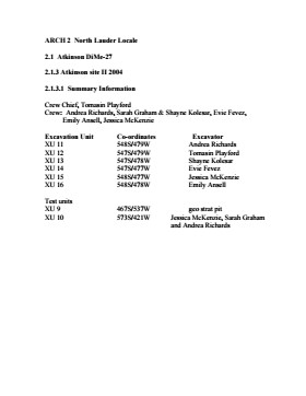
After the flooding of the Souris River in 2004 receded, Tomasin Playford and her crew of Andrea Richards, Sarah Graham and Shane Kolesar returned to the Atkinson site and commenced cleaning up the earlier excavation of Atkinson.
An area east of the Atkinson excavations was also opened for testing in 2004. This area was designated as Atkinson II. In some of the field notes it is referred to as Atkinson East. A test block was opened and fenced off from the cattle with snow fence. A 4m2 block was surveyed in (units 13 - 16) and two partial units that were truncated by the riverbank (units 11 &12) were also placed to the south of the 4m2 block.
Three of the students who had completed the recent field school were hired as crew. Jessica McKenzie, Evie Fevez and Emily Ansell joined the crew at the Atkinson II site.
Recoveries from XU 13 - 16:
Large bison bone was recovered from units 11 and 12 and a metal tobacco box seal was recovered from unit 12. More small pieces of metal found in levels 2 and three together with small bone fragments. A bone fragment with butchering marks from a metal tool was recovered from level 6 and pottery was found in level 9. A few lithic flakes were found in level 13 and in a trench at the bottom of unit 13 above a calcite cemented layer. Recoveries from these tests were sparse and diminished as the excavation series became more distant from the river. It is likely that the remains that were recovered represent the northern edge of these occupations.
The upper occupation at Atkinson II appears to be an early historic occupation with a sparse scatter of bone and a few pieces of metal. The lower layers, below level 7 are likely precontact. Units 9 and 10 were dug as test pits and produced very little in the way of cultural materials.
Scope and Content
Sub-sub-sub series contains: Summary information of field methology, number and co-ordinates of excavations, personnel and their staff position; Field journals are daily records of recoveries, features and activities at the site; Site records include excavation level and unit summaries, feature sheets, profiles; sample records and maps; Artifact catalogues are lists and identifications of all artifacts recovered; Photographs are of excavation units, features, the landscape and personnel.
Field journals have been scanned in multi-page PDF files. Artifact catalogues are PDF files in spreadsheet format. Photographs are in jpeg format
History / Biographical
An area east of the Atkinson excavations was also opened for testing in 2004. This area was designated as Atkinson II and a test block was opened and fenced off from the cattle with snow fence. A 4m2 block was surveyed in (units 13 - 16) and two partial units that were truncated by the riverbank (units 11 &12) were also placed to the south of the 4m2 block. Test units 9 and 10 were also excavated.
Block B consisted of 20 contiguous 1m2 units excavated to 30 cm below surface. (except unit 58 which was excavated to 35 cm bs to obtain extended soil profile). The block is situated in recent oak and poplar forest at the head of a ravine leading to Jock’s Creek, adjacent to an area cleared for market gardening. As was the case with Block A, the understory is heavily overgrown with hazelnut, chokecherry, saskatoon, and a poison ivy/sarsaparilla ground cover.
The soil levels below the sod in Block B consisted of a black, silty, and gritty loam layer from 5 cm to 23 cm below surface, a yellow and sandy clay from 23 cm to 30 cm below surface, and glacial till at 30 cm below surface. As in Block A, limestone cobbles were found throughout the occupation level around the bone. It is evident that bioturbation – primarily tree roots and rodent burrowing – have significantly altered patterns of original deposition of lithics, ceramics and small bone.
The faunal layer lay close to the surface, situated entirely in the black loam 5 cm – 23 cm below surface. The 23 cm depth also marked the end of the dark silty loam. At 10 cm below surface, a discernible patterning of the bone appeared. Concentrations of bone in narrow rows ran in an irregular pattern from the northwest to the southeast part of the block. This pattern was most apparent in the north end of the block which is the highest point in the block. In the same 1m2 unit, patches of weathered, very poorly preserved bone would be found lying close to patches of well preserved bone. It is believed that this variability in preservation results from uneven rates of burial due to taphic activities of pocket gophers or other agents of bioturbation. The same pattern of uneven preservation occurs over much of the locale but is most evident in Block B.
Diagnostic lithics included eleven projectile points that were predominantly Plains or Prairie Side-notch types, but included two unnotched triangular points. Cord-wrapped impressed rim sherds and body sherds were recovered. The ceramics are variants of the Woodland Blackduck horizon.
RC dates: XU49 – 675/80 BP XU 59 – 705/75BP.
Scope and Content
Sub-sub-sub series contains: Summary information of field methology, number and co-ordinates of excavations, personnel and their staff position; Field journals are daily records of recoveries, features and activities at the site; Site records include excavation level and unit summaries, feature sheets, profiles; sample records and maps; Artifact catalogues are lists and identifications of all artifacts recovered; Photographs are of excavation units, features, the landscape and personnel.
Block C was situated in sparse oak forest with an understory of saskatoon, hazelnut and a thick ground cover of poison ivy and sarsaparilla. The block measured 3m and 3m and contained nine excavation units. All units were excavated to 35cm below surface. The soil horizons were much like the other blocks, except for a rusty brown stain in the first level, giving the upper black loam a mottled appearance. The brown patches were clay mixed with loam and were harder than the surrounding matrix. No definitive interpretation of these phenomena was attempted but this effect may be the result of natural brush or forest fires. Under the 5cm so d/humus (Ah) layer, the loam horizon extended approximately 5cm – 25 cm below surface, and averaged 20 cm thick. Bone was concentrated within this horizon between 10 cm – 20 cm below surface.
Block C was notable for its concentrations of articulated bison bone. Most noteworthy was an articulated unit composed of lumbar vertebrae, pelvis, and sacrum. Several thoracic vertebra/proximal rib end concentrations were also recovered. There were more vertebrae and rib sections recovered in the units in proportion to other bones. A few sherds, some debitage and a single Prairie Side-Notched point fragment were among the recoveries. Based on the quantity of bone, the density of the bone layer, and the articulated butchering units the area has been interpreted as a bone midden.
Faunal material was analysed by Jessica MacKenzie for her Honours Thesis: "A reconstruction of butchering processes in Block C from the Lovstrom site DjLx-1 in Southwestern Manitoba."
Radiocarbon date: 850/115BP XU 79.
Scope and Content
Sub-sub-sub series contains: Summary information of field methology, number and co-ordinates of excavations, personnel and their staff position; Field journals are daily records of recoveries, features and activities at the site; Site records include excavation level and unit summaries, feature sheets, profiles; sample records and maps; Artifact catalogues are lists and identifications of all artifacts recovered; Photographs are of excavation units, features, the landscape and personnel.
Field journals have been scanned in multi-page PDF files. Artifact catalogues are PDF files in spreadsheet format. Photographs are in jpeg format.
History / Biographical
The Crepeele site was identified from the results of the Casselman survey and excavated in 2003, 2004, 2005 and 2007. In 2005 and 2007 the Brandon University Archaeology Field School was held at the Crepeele site in the Crepeele locale.
In 2008 a small crew returned to the site to gather further samples and verify profiles. Three units (XU 50, 51 and 52) were excavated with faunal (animal bone), lithics, fire cracked rock, diagnostic lithics and ceramics recovered from the site. There are 455 records in the artifact catalogue.
Scope and Content
Sub-sub-sub series contains: Summary information of field methology, number and co-ordinates of excavations, personnel and their staff position; Field journalsare daily records of recoveries, features and activities at the site; Site records include excavation level and unit summaries, feature sheets, profiles; sample records and maps; Artifact catalogues are lists and identifications of all artifacts recovered; Photographs are of excavation units, features, the landscape and personnel.
The Sarah site was chosen for excavation based on the results of the Casselman survey. The survey recovered significant amounts of faunal remains, some ceramics and lithics from the test pits. Excavations took place in 2003 at Crepeele West (Units 1-5) and Crepeele East (Units 6-9). The site was subsequently renamed the Sarah site DiMe-28. In 2004 another 9 units were excavated (Units 10-18).
Based on the recoveries it was determined that the Sarah site is a stratified site with woodland ceramics in the upper occupation and late woodland points in both of the upper occupations. These upper occupations produced abundant bison bone including foetal bone. The lower occupations produced less bone and no foetal bone, although absence of foetal bone in the lower occupations does not necessarily indicate a warm season occupation. This could be due to sample error or perthotaxic factors such as scavenging of the fragile bone by dogs or other carnivores.
The dates from the Sarah site include 550+/-40 B.P.; 1430+/-80 B.P; 2810+/-80 B.P.; 3120+/-130 B.P. The lower occupations did not yield any diagnostic materials although debitage was abundant. These occupations were most productive at the edge of the large sand dune at the southern edge of the excavations. It is assumed that the major portion of these occupations have been overridden by the dune in the past 3000 years. Heavy earthmoving equipment would be required to remove this overburden which limits the possibility of future excavation.
Environment
The Sarah site is a large area located at the eastern end of the Crepeele locale. Ground cover is a mosaic of aspen poplar groves and patches of mesic grass prairie. Excavation profiles indicate that this has been the situation since early precontact times, although as local climatic conditions change (primarily rainfall), the relative size of these areas and where they may have occurred also changed. The soil is aeolian sand sheet derived from delta outwash deposits along the western edge of glacial Lake Hind. The present topography is a variable dune landscape reworked by aeolian activity that creates a mosaic of microhabitats. These include forested patches in the lee of sand dunes with grassland on the southern and western exposures and small damp lowlands that support balsam poplar, willows, red osier dogwood, high-bush cranberry and water birch. There is no permanent water source in the area although a small seasonal stream meanders through a damp lowland to the east of the Sarah site.
Scope and Content
Sub-series has been divided into sub sub series including: Sarah 2003 and Sarah 2004,
Field journals have been scanned in multi-page PDF files. Artifact catalogues are PDF files in spreadsheet format. Photographs are in jpeg format.
History / Biographical
The Sarah site was chosen for excavation based on the results of the Casselman survey. The survey recovered significant amounts of faunal remains, some ceramics and lithics from the test pits. Excavations took place in 2003 at Crepeele West (Units 1-5) and Crepeele East (Units 6-9). The site was subsequently renamed the Sarah site DiMe-28.
Units 1 to 9 were excavated by supervisor James Graham and crew of Sarah Graham, Mike Evans, Todd Kristensen, Shayne Kolesar, Lisa Sonnenburg and Emily Ansell.
Scope and Content
Sub-sub-sub series contains: Summary information of field methology, number and co-ordinates of excavations, personnel and their staff position; Field journalsare daily records of recoveries, features and activities at the site; Site records include excavation level and unit summaries, feature sheets, profiles; sample records and maps; Artifact catalogues are lists and identifications of all artifacts recovered; Photographs are of excavation units, features, the landscape and personnel.
Field journals have been scanned in multi-page PDF files. Artifact catalogues are PDF files in spreadsheet format. Photographs are in jpeg format.
History / Biographical
The Sarah site was initially chosen for excavation based on the results of the Casselman survey. The survey recovered significant amounts of faunal remains, some ceramics and lithics from the test pits. Excavations took place in 2003 at the Sarah site DiMe-28.
In 2004 further excavation took place as part of a Brandon University Archaeology Field School. Units 10 to 18 were excavated with Denise Ens as the instructor and James Graham teaching assistant.
Scope and Content
Sub-sub-sub series contains: Summary information of field methology, number and co-ordinates of excavations, personnel and their staff position; Field journalsare daily records of recoveries, features and activities at the site; Site records include excavation level and unit summaries, feature sheets, profiles; sample records and maps; Artifact catalogues are lists and identifications of all artifacts recovered; Photographs are of excavation units, features, the landscape and personnel.
Sub-series consists of four scrapbooks detailing life at Clark Hall and Brandon College. They include newspaper clippings, photographs, cards, various programs and ephemera.
Storage Location
RG 1 Brandon College fonds
Series 9: Clark Hall Women's Residence
The Graham site is a located adjacent to the Crepeele site towards the western end of the Crepeele locale. The Graham site was initially designated as a separate site early in the testing of the Crepeele locale due to what appeared to be a distinction between Early and Late Woodland ceramics. Subsequent testing has shown that this distinction was premature and that the cultural mosaic represented in the western section of the Crepeele locale may not readily separate in this manner. However, due to the records management that was already in place, the original separate designations have been retained.
Environment
Ground cover is a mosaic of aspen poplar groves and patches of mesic grass prairie. Excavation profiles indicate that this has been the situation since early precontact times, although as local climatic conditions change (primarily rainfall), the relative size of these areas and where they may have occurred also changed. The soil is aeolian sand sheet derived from delta outwash deposits along the western edge of glacial Lake Hind. The present topography is a variable dune landscape reworked by aeolian activity that creates a mosaic of microhabitats. These include forested patches in the lee of sand dunes grassland on the southern and western exposures and small damp lowlands that support balsam poplar, willows, red osier dogwood, high-bush cranberry and water birch. There is no permanent water source in the area although a small seasonal stream meanders through a damp lowland along the eastern margin of the Crepeele locale.
Excavations at the Graham site took place from 2004 to 2008. Analyses of the recoveries shows that, with two exceptions, all of the occupations that have been tested produced bison foetal bone. The presence of foetal bison is a strong indicator of wintering occupations...The absence of foetal in some area does not necessarily indicate warm season occupations since these excavation series are small and the absence could be due to sample error or perthotaxic factors, such as scavenging of the fragile bone by dogs or other carnivores.
From this evidence the Graham site has been interpreted as being primarily a wintering area. This is consistent with the lack of surface water (snow would serve as a substitute in winter) and the abundance of wood for fuel – a critical requirement for winter occupation. Cultural occupations date from Mortlach circa 250 B.P to woodland circa 580 B.P.
Scope and Content
Sub-series has been divided into sub sub series including: Graham 2004, Graham 2005, Graham 2006 and Graham 2008
Field journals have been scanned in multi-page PDF files. Artifact catalogues are PDF files in spreadsheet format. Photographs are in jpeg format.
History / Biographical
Graham units 9 and 14 were excavated with the Crepeele site in 2004 and were reassigned to the Graham site DiMe-30 keeping the same unit numbers. Tomasin Playford was crew chief in 2004.
The Graham site was initially designated as a separate site early in the testing of the Crepeele locale due to what appeared to be a distinction between Early and Late Woodland ceramics. Subsequent testing has shown that this distinction was premature and that the cultural mosaic represented in the western section of the Crepeele locale does not readily separate in this manner.
Scope and Content
Sub-sub-sub series contains: Summary information of field methology, number and co-ordinates of excavations, personnel and their staff position; Field journalsare daily records of recoveries, features and activities at the site; Site records include excavation level and unit summaries, feature sheets, profiles; sample records and maps; Artifact catalogues are lists and identifications of all artifacts recovered; Photographs are of excavation units, features, the landscape and personnel.
Block D was wooded with oak and an understory of saskatoon and hazelnut with a thick ground cover of poison ivy and sarsaparilla. Root and rodent disturbance was extensive.
Based on the recoveries from Test Unit 22 during the survey, further excavations were carried out. Two units 87 and 93 were excavated in 1987. A further four units were excavated in 1988. There appears to be a pre contact occupation and a protohistoric feature within the block.
Diagnostic lithics included a chert Plains Side-notch projectile point, and a large Woodland side-notched point. The lithic materials from Block D are primarily local cherts followed in abundance by Knife River Flint and Tongue River Silicified Sediment – both of which are exotics imported from the southwest. Faunal remains were primarily bison.
Thin-walled obliterated fabric impressed pottery with grit temper was recovered in all units. Diagnostic ceramics included two rims, one with a fabric impressed exterior and the lip notched with dowel impressions, and a second thick walled rim was fabric impressed to the lip. The ceramic wares appear to be essentially a Woodland complex with overtones of Plains influence.
RC date: 230/90 BP.
Scope and Content
Sub-series has been divided into sub sub series including: Lovstrom Block D 1987 and Lovstrom Block D 1988.
Field journals have been scanned in multi-page PDF files. Artifact catalogues are PDF files in spreadsheet format. Photographs are in jpeg format.
History / Biographical
Block D is a wooded with oak and an understory of saskatoon and hazelnut with a thick ground cover of poison ivy and sarsaparilla. Root and rodent disturbance was extensive.
Directed by Dr. Nicholson and with Jane Gibson as crew chief, two units were opened in Block D in 1987. A hearth was identified with a ring of stones containing charcoal and burnt bone. Recoveries included two rim sherds with tool-impressed decorations along the outer edge and two prairie side-notched points. Associated bone was primarily appendicular, indicating secondary butchering.
A radiocarbon date of 230+/-90 B.P. recovered in 1987 from 17 cm below surface is consistent with a Protohistoric occupation.
Scope and Content
Sub-sub-sub series contains: Summary information of field methology, number and co-ordinates of excavations, personnel and their staff position; Field journals are daily records of recoveries, features and activities at the site; Site records include excavation level and unit summaries, feature sheets, profiles; sample records and maps; Artifact catalogues are lists and identifications of all artifacts recovered; Photographs are of excavation units, features, the landscape and personnel.
Field journals have been scanned in multi-page PDF files. Artifact catalogues are PDF files in spreadsheet format. Photographs are in jpeg format.
History / Biographical
Block D is a wooded with oak and an understory of saskatoon and hazelnut with a thick ground cover of poison ivy and sarsaparilla. Root and rodent disturbance was extensive.
Directed by Dr. Nicholson with Ian Kuijit as crew chief, five units were opened in Block D in 1988. Four units were excavated: 88, 91, 92 and 94. A feature in units 91 and 92 contained extensive deposits of large bison bone and fire-cracked rock. Several of the lower limb elements were articulated. Bone deposits were associated with numerous large fire-cracked rocks and were clustered in an area of one meter. Also recovered were a side-notched projectile point and two historic gun flints.
Judging from the association of the gun flints, projectile points, and bison bone, as well as the radiocarbon date of 230+/-90 B.P. recovered in 1987, it appears that this feature is from the Protohistoric period and related to refuse disposal.
Scope and Content
Sub-sub-sub series contains: Summary information of field methology, number and co-ordinates of excavations, personnel and their staff position; Field journals are daily records of recoveries, features and activities at the site; Site records include excavation level and unit summaries, feature sheets, profiles; sample records and maps; Artifact catalogues are lists and identifications of all artifacts recovered; Photographs are of excavation units, features, the landscape and personnel.
This site is situated in a naturally sheltered area with a low rise to the east and south partly encircling a flat area open to the west. Present natural vegetation is an open oak forest with a light understory of saskatoon, hazelnut, poison ivy and sarsaparilla. It is situated on the till plain at the upper end of a ravine leading to Jock’s Creek.
Two test units six meters apart were excavated in 1987 and produced cultural materials which warranted a block excavation, so seven contiguous 1m2 units were then opened. These units proved to be very productive of cultural remains. Subsequent excavations in 1988 increased the number of excavated units to 21. In 1991 a further eight units were excavated for a total of 29 excavations and two test units. Excavations went deeper in this block than in Blocks C or B. Remains from the block included bison bone, bone tools, fire-cracked rock, ceramics, lithics including tools and debitage and a hearth. Another occupation was recovered in 1991 containing a hearth and living floor.
Radiocarbon samples have produced two distinct sets of radiocarbon dates from 1987 and 1988 excavations. There appears to be two or possibly three cultural horizons definable within this block.
An upper cultural horizon, located between 14-21 cm below surface, contains large bison bone and fire-cracked rock dating to 465/100B.P from XU 128.
A lower horizon in the 20-25 cm level contained FCR, bison bone and lithic scatter that was dated to 675/70 B.P. from XU 122 and 715/110 from XU 114.
Scope and Content
Sub-series has been divided into sub sub series including: Lovstrom Block E 1987, Lovstrom Block E 1988 and Lovstrom Block E 1991.
Field journals have been scanned in multi-page PDF files. Artifact catalogues are PDF files in spreadsheet format. Photographs are in jpeg format.
History / Biographical
Directed by Dr. Nicholson and with Jane Gibson as crew chief, two test units TU 107 and TU 108 were excavated six meters apart in 1987 and produced cultural materials which warranted a block excavation. Seven contiguous 1m2 units were opened in 1987 (XU 118, 119, 122, 123, 125, 126 (TU108) and 127). This block proved to be very productive of cultural remains. Large bison bone and fire-cracked rock indicated butchering/processing areas. Two bone tools, fabricated from scapulae were recovered. One is a bone knife – possibly a squash knife – and the other is a bifurcated scapula, which may have been a hoe.
Scope and Content
Sub-sub-sub series contains: Summary information of field methology, number and co-ordinates of excavations, personnel and their staff position; Field journals are daily records of recoveries, features and activities at the site; Site records include excavation level and unit summaries, feature sheets, profiles; sample records and maps; Artifact catalogues are lists and identifications of all artifacts recovered; Photographs are of excavation units, features, the landscape and personnel.
Field journals have been scanned in multi-page PDF files. Artifact catalogues are PDF files in spreadsheet format. Photographs are in jpeg format.
History / Biographical
Directed by Dr. Nicholson and with Ian Kuijt as crew chief, fourteen additional units were excavated in Block E in 1988. Stratigraphic evidence of distinct activity areas at successive depths and radiocarbon dates indicate at least three occupations (380 BP, 700 BP and 860 B P).
Three identified activity clusters occur stratigraphically, supporting these dated occupations. A clear distinction between Blackduck and Vickers Focus ceramics is evident in this Block. Sixteen small side-notched and un-notched points were recovered in this excavation series as well as numerous unifacial scrapers. Fragments from a grey soapstone tube were also recovered.
Scope and Content
Sub-sub-sub series contains: Summary information of field methology, number and co-ordinates of excavations, personnel and their staff position; Field journals are daily records of recoveries, features and activities at the site; Site records include excavation level and unit summaries, feature sheets, profiles; sample records and maps; Artifact catalogues are lists and identifications of all artifacts recovered; Photographs are of excavation units, features, the landscape and personnel.
Field journals have been scanned in multi-page PDF files. Artifact catalogues are PDF files in spreadsheet format. Photographs are in jpeg format.
History / Biographical
The Atkinson site had been flooded in 2005 and there was concern about the amount of damage that might have occurred. A small crew of Tomasin Playford, Michelle Drysdale and Jessica McKenzie returned to the Atkinson site with the goals of obtaining a detailed profile of the stratigraphy at the north end of the occupation and to determine if the site extended contiguously towards the east. Two test pits were planned as well as the investigation of a couple of hearths found eroding from the riverbank Work commenced July 4th and finished July 21st.
To the north of XU 8 (Gowen occupation) an excavation unit 18 was opened and shovel shaved to a depth of 200cm. At 195cm below surface a point bar deposit was identified indicating that any lower occupations would likely have been eroded by an earlier channel cutting event prior to formation of this point bar depositional event. Golf tees were inserted into the edge of the profile to indicate the 5cm levels superimposed on a digital photo of the section. Lithic flakes and bone fragments were scattered thoughout the stratigraphic column. A radiocarbon date of 440 B.P. was obtained from the unit, indicating a much later occupation than Gowen.
Unit 19 was excavated but only yielded a small Besant component containing a small hearth (H#3) In level 9, a point tip and a small biface as well as a few undecorated pot sherds were recovered. These two units defined the extent of the Atkinson I site. An unknowable area of the site has been eroded away by the encroaching Souris River.
The two small exposed hearths were excavated but only yielded a small amount of material. Hearth 4, at the western edge of the Atkinson block yielded only a small amount of charcoal , mixed with burnt bone and a few small lithic flakes. Hearth 5, located in the high cut bank west of the main site yielded a small amount of bone from a small ungulate, a muskrat and a bird as well as a percussion cap. This latter recovery indicated that this was an early historic period site.
Scope and Content
Sub-sub-sub series contains: Summary information of field methology, number and co-ordinates of excavations, personnel and their staff position; Field journals are daily records of recoveries, features and activities at the site; Site records include excavation level and unit summaries, feature sheets, profiles; sample records and maps; Artifact catalogues are lists and identifications of all artifacts recovered; Photographs are of excavation units, features, the landscape and personnel.
Flintstone Hill is located on the north bank of the Souris River. It is a deeply stratified lacustrine, fluvial and aeolian soil profile that has been exposed by the river through stream-bank erosion. This section is thought to be the most complete middle to late Holocene exposure on the northeastern plains. While the value of the site is primarily for paleo-environmental research and reconstruction, cultural deposits have been identified at the site. Local collectors have picked up lithic materials as they eroded out of the bank for the past several decades and it was they who had named the site. Mr. Bruce Timms from Lauder first drew the Flintstone Hill site to the attention of Dr. Nicholson of Brandon University.
During the mid 1990’s to the early 2000’s archaeological testing took place on Flintstone Hill. In 1998, an archaeological field crew dug a series of overlapping trenches down the slope of the profile and produced a schematic drawing. A peat layer at the bottom of this profile, dated from the top at 9,400 RCY and at the bottom to 10,400 RCY, has provided details of marsh plant and insect communities at this time.
Subsequent archaeological investigations at the site recovered several cultural deposits including: a hearth dating to 3250+/-70 R.C.Y. (BETA 109529); a butchered atlas bone 4090+/-70 R.C.Y. (BETA 109990); and bone fragments accompanied by Swan River Chert and Knife River Flint lithic flakes 5350+/-50 (BETA 109530). While no diagnostic tools were recovered, these dates suggest that this occupation, which is contemporary with the Atkinson site, may be a Gowen occupation.
Extensive paleo-environmental research has been conducted at the site. Dr. Running, a geomorphologist from the University of Wisconsin – Eau Claire, participated in the Study of Cultural Adaptations in the Prairie Ecozone (SCAPE) Project and he and his students tested the site for several years. He was joined in this effort by Dr. Havholm, Dr. Boyd, Dr. Wiseman, Dr. Beaudoin, and other SCAPE researchers in the interpretation of the paleo-environment of the Glacial Lake Hind basin. The following article is recommended reading.
Running, Garry L., Karen G. Havholm, Matt Boyd and Dion J. Wiseman
2002 Holocene Stratigraphy and Geomorphology of Flintstone Hill, Lauder Sandhills, Glacial Lake Hind Basin, Southwestern Manitoba. Geographie Physique et Quaternaire
56(2-3):291-303.
Scope and Content
Sub series has been divided into two sub sub series including: (1) Flintstone Hill 1997 (2) Flintstone Hill 1998-2000
Field journals have been scanned in multi-page PDF files. Artifact catalogues are PDF files in spreadsheet format. Photographs are in jpeg format.
History / Biographical
During the mid 1990’s to the early 2000’s archaeological surveying and testing took place on Flintstone Hill. In 1997 testing at the site revealed a bison skull eroding from the cutbank. A field crew dug a series of overlapping trenches down the slope of the profile and produced a schematic drawing. A radiocarbon date from the lower edge of the profile gave a date of 10,400 RCY.
Test units along the cutbank recovered lithics, soil samples, fire-cracked rock, charcoal, bison remains including a very large bison skull measuring 430-440 cm and thought to be an ancient species.
Radiocarbon dates at Flintstone hill gave dates of: a hearth dating to 3250+/-70 R.C.Y. (BETA 109529); a butchered atlas bone 4090+/-70 R.C.Y. (BETA 109990); and bone fragments accompanied by Swan River Chert and Knife River Flint lithic flakes 5350+/-50 (BETA 109530). While no diagnostic tools were recovered, these dates suggest that this occupation, which is contemporary with the Atkinson site, may be a Gowen occupation.
Scope and Content
Sub-sub-sub series contains: Summary information of field methology, number and co-ordinates of excavations, personnel and their staff position; Field journals are daily records of recoveries, features and activities at the site; Site records include excavation level and unit summaries, feature sheets, profiles; sample records and maps; Artifact catalogues are lists and identifications of all artifacts recovered; Photographs are of excavation units, features, the landscape and personnel.