Skip header and navigation

Revise Search

20 records – page 2 of 1.

ARCH 2: North Lauder locale

http://archives.brandonu.ca/en/permalink/descriptions12079
Part Of
RG 7 Beverley Nicholson fonds
Description Level
Series
GMD
multiple media
Date Range
1997 to present
Accession Number
1-2010
Part Of
RG 7 Beverley Nicholson fonds
Description Level
Series
Series Number
2
Accession Number
1-2010
GMD
multiple media
Date Range
1997 to present
History / Biographical
ARCH 2: North Lauder Locale The North Lauder locale has a long archaeological and geological history that is important for understanding the forces that shaped the region. Archaeological research in the locale shows that the area has been occupied by humans for at least the past 6,500 years. Environmental forces provided an area of diverse resources that attracted early peoples. Environment of the Lauder Sandhills The North Lauder locale is part of the greater Lauder Sandhills area. The glaciers that covered this region began to recede approximately 11,000 years ago leaving a large lake known as glacial Lake Hind. The Souris River, the Lauder Sandhills and the Oak Lake Aquifer are remnants of the environmental and geological forces that shaped the region. The Lauder Sandhills region is characterized by a landscape of sand sheets and stabilized sand dunes interspersed with a variety of wetlands. This complex topographic and hydrological situation favoured the development of an island mosaic of mixed forest, wetland and meadow, surrounded by mixed grass prairie. The result was a large, isolated ecotone which provided a rich variety of subsistence resources for hunter-gatherers. Research in the Lauder Sandhills Archaeologists from Brandon University have been conducting research in the Lauder Sandhills since 1991. Research in the North Lauder locale has focused on the Atkinson site, a 6,500 year old hunter-gatherer site and Flintstone Hill. The Atkinson site 
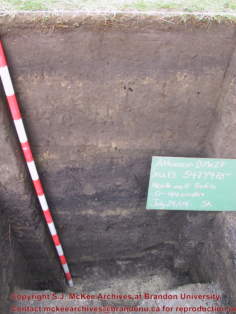
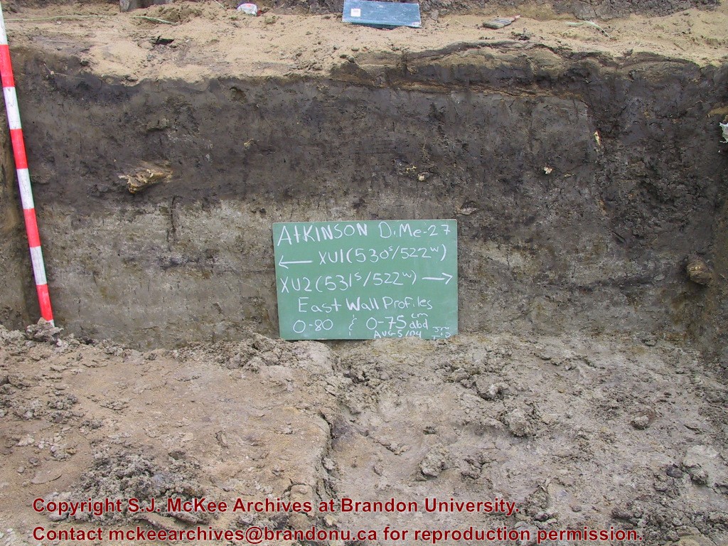
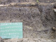
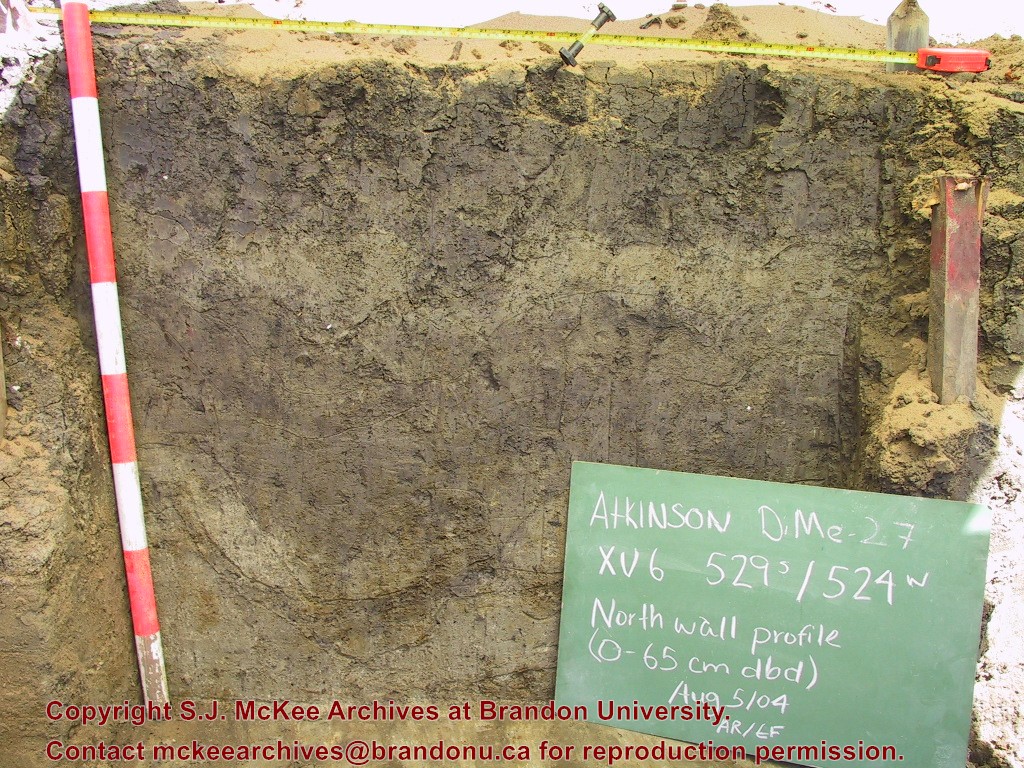
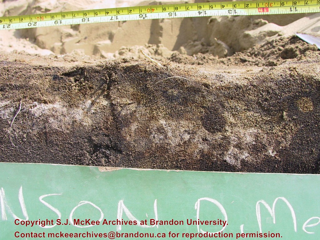
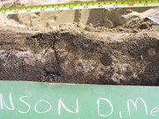
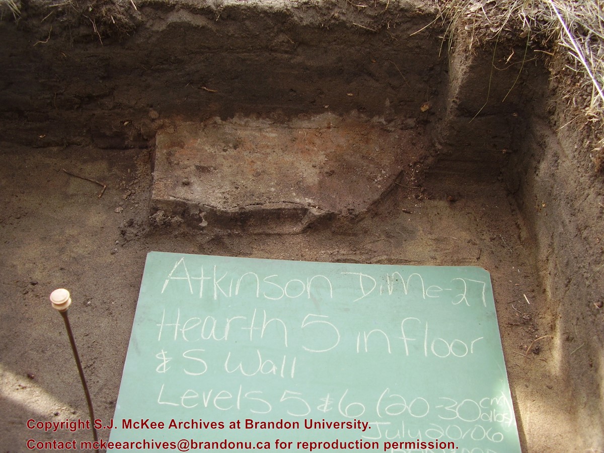
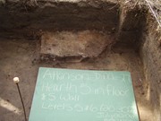
The Atkinson site is one of the oldest excavated sites in Manitoba and has been Radiocarbon dated to 6,500 years before present. The Atkinson site is located on the bank of the Souris River and was discovered when a hearth (fire pit) was seen eroding out of the bank. Based on the date of the site and the kind of lithics (stone tools) present it is considered a Gowen occupation. The Atkinson site is evidence that bison hunters were active on the northern plains at a very early date. Similar sites have also been found on the High Plains in the U.S. and are referred to as the Mummy Cave Complex. The Atkinson Site is of great importance as it is the first undisturbed site of this type to be excavated in Manitoba and extends the range of these sites south and east from the type-sites in central Saskatchewan. Flintstone Hill The geomorphology of the glacial Lake Hind Basin over the past 11,000 years is known primarily through the study of a cut bank along the Souris River. Flint Stone Hill contains the most complete stratigraphic record for the post-glacial period on the northern plains. The site has been extensively studied by geoarchaeologists, geologists and paleoenvironmentalists over many years and their findings have contributed to our understanding of the region. The North Lauder locale Borden designations of Atkinson site DiMe-27 and Flintstone Hill site DiMe-26. Borden System Archaeological sites in Canada are identified by the Borden system, which is a uniform site designation system. The country is divided into grids based on latitude and longitude in blocks of 10 x 20 minutes. The first 4 letters indicate the block and the following numbers indicate the actual site. For example the area of the Lauder Sandhills in southwestern Manitoba is identified by the letters DM and the North Lauder locale within that area is DiMe. The Atkinson site is DiMe-27 and the Flintstone Hill site DiMe-26. As new sites are discovered they will be numbered sequentially.
Scope and Content
The Series has been divided into two sub-series, including (1) Atkinson site DiMe-27 and Flintstone Hill site DiMe-26.
Name Access
North Lauder locale
Subject Access
Archaeology Atkinson site DiMe-27
Arrangement
Series is arranged by site and by year of field work.
Show Less

Assiniboine avenue ramp to 1st street bridge including CPR Extra 5178 West

http://archives.brandonu.ca/en/permalink/descriptions8723
Part Of
RG 11 Lawrence Stuckey fonds
Description Level
Item
GMD
graphic
Date Range
1937
Accession Number
1-2002
Part Of
RG 11 Lawrence Stuckey fonds
Creator
Photographer: George Harris
Description Level
Item
Series Number
3.9
Item Number
1-2002.3.9.103
Accession Number
1-2002
GMD
graphic
Date Range
1937
Physical Description
8" x 10" (b/w)
Scope and Content
Photograph shows the ramp, bridge and train. The Empire Brewery is in the background.
Notes
Corresponds with negative 1-2002.3.9.BA4.
Repro Restriction
The McKee Archives is the copyright holder for the Stuckey materials.
Location Original
1-2002.3.1BA4
Storage Location
RG 5 photograph storage drawer
Images
Show Less

Assiniboine River Bridge North of Kemnay

http://archives.brandonu.ca/en/permalink/descriptions9920
Part Of
RG 11 Lawrence Stuckey fonds
Description Level
Item
GMD
graphic
Date Range
[ca. 1938]
Accession Number
1-2002
Part Of
RG 11 Lawrence Stuckey fonds
Creator
George H. Harris
Description Level
Item
Series Number
3.1
Item Number
1-2002.3.1OB5(1)
Accession Number
1-2002
GMD
graphic
Date Range
[ca. 1938]
Physical Description
2 1/2" x 2 1/2"
Material Details
Negative
History / Biographical
This bridge was condemned in the late 1930s but cyclists continued to use it until it was torn down (approximately 1940)
Until the early 1920s the Canadian Pacific Railway maintained a well and pumping station near the southeast corner of this bridge, which pumped water through a pipeline to a locomotive watering tank at Kemnay.
Custodial History
For custodial history see the collection level description of the Lawrence Stuckey collection.
Scope and Content
Assiniboine River Bridge North of Kemnay
Notes
[Mr. Stuckey put a negative and print in the same envelope. We have separated them, numbering the negative OB5(1) and the print OB5(1a).]
Name Access
Assiniboine River Bridge North of Kemnay
Subject Access
manmade geographic features
bridges
Brandon Area Bridges
Repro Restriction
The McKee Archives is the copyright holder for the Stuckey materials.
Storage Location
Lawrence Stuckey collection
Images
Show Less

Assiniboine River Bridge North of Kemnay

http://archives.brandonu.ca/en/permalink/descriptions9921
Part Of
RG 11 Lawrence Stuckey fonds
Description Level
Item
GMD
graphic
Date Range
[ca. 1938]
Accession Number
1-2002
Part Of
RG 11 Lawrence Stuckey fonds
Creator
George H. Harris
Description Level
Item
Series Number
3.1
Item Number
1-2002.3.1OB5(1a)
Accession Number
1-2002
GMD
graphic
Date Range
[ca. 1938]
Physical Description
2 1/2" x 2 1/2"
Material Details
Photograph
History / Biographical
This bridge was condemned in the late 1930s but cyclists continued to use it until it was torn down (approximately 1940)
Until the early 1920s the Canadian Pacific Railway maintained a well and pumping station near the southeast corner of this bridge, which pumped water through a pipeline to a locomotive watering tank at Kemnay.
Custodial History
For custodial history see the collection level description of the Lawrence Stuckey collection.
Scope and Content
Assiniboine River Bridge North of Kemnay
Notes
[Mr. Stuckey put a negative and print in the same envelope. We have separated them, numbering the negative OB5(1) and the print OB5(1a).]
Name Access
Assiniboine River Bridge North of Kemnay
Subject Access
manmade geographic features
bridges
Brandon Area Bridges
Repro Restriction
The McKee Archives is the copyright holder for the Stuckey materials.
Storage Location
Lawrence Stuckey collection
Images
Show Less

Atkinson II site 2004 - profile of the north wall of XU 13

http://archives.brandonu.ca/en/permalink/descriptions12253
Part Of
RG 7 Beverley Nicholson fonds
Description Level
Item
GMD
graphic
Date Range
2004
Accession Number
1-2010
Part Of
RG 7 Beverley Nicholson fonds
Description Level
Item
Series Number
2.1.3.5
Item Number
2.1.3.5.13
Accession Number
1-2010
GMD
graphic
Date Range
2004
Physical Description
768 x 1024 (607)
Material Details
JPEG
History / Biographical
Photograph taken during 2004 Brandon University Archaeology excavations at Atkinson II site.
Scope and Content
Profile of the north wall of excavation unit 13 at the Atkinson II site 2004.
Name Access
Atkinson II site 2004 - profile of the north wall of XU 13
Subject Access
Archaeology North lauder locale Atkinson site DiMe-27 Atkinson II site 2004 photographs
Images
Show Less

Atkinson site 2003 - site record north wall XU 1

http://archives.brandonu.ca/en/permalink/descriptions12169
Part Of
RG 7 Beverley Nicholson fonds
Description Level
File
Accession Number
1-2010
Part Of
RG 7 Beverley Nicholson fonds
Description Level
File
Series Number
2.1.1.3
File Number
5
Accession Number
1-2010
Physical Description
one page
Material Details
PDF
History / Biographical
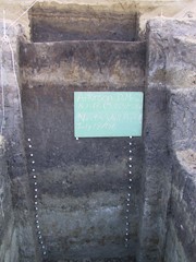
Record of excavation unit 1 north wall profile at the Atkinson site 2003.
Scope and Content
Site excavation records of excavation units may include: level summaries, floor plans, feature sheets, wall profiles, unit summaries and any other additional information relating to the unit.
Name Access
Atkinson site 2003 - site record north wall XU 1
Subject Access
Archaeology North Lauder locale
Atkinson site DiMe-29 Atkinson site 2003
Documents

2.1.1.3.5__N_Wall_XU1.pdf

Read PDF Download PDF
Show Less

Atkinson site 2004 - east wall of XU 1 and 2

http://archives.brandonu.ca/en/permalink/descriptions12213
Part Of
RG 7 Beverley Nicholson fonds
Description Level
Item
GMD
graphic
Date Range
2004
Accession Number
1-2010
Part Of
RG 7 Beverley Nicholson fonds
Description Level
Item
Series Number
2.1.2.5
Item Number
2.1.2.5.8
Accession Number
1-2010
GMD
graphic
Date Range
2004
Physical Description
1024 x 768 (416 KB)
Material Details
JPEG
History / Biographical
Photograph taken during 2004 Brandon University Archaeology excavations at Atkinson site.
Scope and Content
Excavation units 1 and 2, east wall.
Name Access
Atkinson site 2004 - east wall of XU 1 and 2
Subject Access
Archaeology North lauder locale Atkinson site DiMe-27 Atkinson site 2004 photographs
Images
Show Less

Atkinson site 2004 - east wall of XU 2

http://archives.brandonu.ca/en/permalink/descriptions12216
Part Of
RG 7 Beverley Nicholson fonds
Description Level
Item
GMD
graphic
Date Range
2004
Accession Number
1-2010
Part Of
RG 7 Beverley Nicholson fonds
Description Level
Item
Series Number
2.1.2.5
Item Number
2.1.2.5.11
Accession Number
1-2010
GMD
graphic
Date Range
2004
Physical Description
1024 x 768 (457 KB)
Material Details
JPEG
History / Biographical
Photograph taken during 2004 Brandon University Archaeology excavations at Atkinson site.
Scope and Content
Excavation unit 2, east wall profile.
Name Access
Atkinson site 2004 - east wall of XU 2
Subject Access
Archaeology North lauder locale Atkinson site DiMe-27 Atkinson site 2004 photographs
Images
Show Less

Atkinson site 2004 - XU 6 north wall profile

http://archives.brandonu.ca/en/permalink/descriptions12257
Part Of
RG 7 Beverley Nicholson fonds
Description Level
Item
GMD
graphic
Date Range
2004
Accession Number
1-2010
Part Of
RG 7 Beverley Nicholson fonds
Description Level
Item
Series Number
2.1.2.5
Item Number
2.1.2.5.12
Accession Number
1-2010
GMD
graphic
Date Range
2004
Physical Description
1024 x 768 (440 KB)
Material Details
JPEG
History / Biographical
Photograph taken during 2004 Brandon University Archaeology excavations at Atkinson site.
Scope and Content
Excavation unit 6, north wall profile.
Name Access
Atkinson site 2004 - XU 6 north wall profile
Subject Access
Archaeology North lauder locale Atkinson site DiMe-27 Atkinson site 2004 photographs
Images
Show Less

Atkinson site 2004 - XU 7 north wall profile

http://archives.brandonu.ca/en/permalink/descriptions12217
Part Of
RG 7 Beverley Nicholson fonds
Description Level
Item
GMD
graphic
Date Range
2004
Accession Number
1-2010
Part Of
RG 7 Beverley Nicholson fonds
Description Level
Item
Series Number
2.1.2.5
Item Number
2.1.2.5.13
Accession Number
1-2010
GMD
graphic
Date Range
2004
Physical Description
2048 x 1536 (1501 KB)
Material Details
JPEG
History / Biographical
Photograph taken during 2004 Brandon University Archaeology excavations at Atkinson site.
Scope and Content
Excavation unit 7, north wall profile.
Name Access
Atkinson site 2004 - XU 7 north wall profile
Subject Access
Archaeology North lauder locale Atkinson site DiMe-27 Atkinson site 2004 photographs
Images
Show Less

Atkinson site 2006 - hearth 3 north profile

http://archives.brandonu.ca/en/permalink/descriptions12269
Part Of
RG 7 Beverley Nicholson fonds
Description Level
Item
GMD
graphic
Date Range
2006
Accession Number
1-2010
Part Of
RG 7 Beverley Nicholson fonds
Description Level
Item
Series Number
2.1.4.5
Item Number
2.1.4.5.3
Accession Number
1-2010
GMD
graphic
Date Range
2006
Physical Description
1024 x768 (769)
Material Details
JPEG
History / Biographical
Photograph taken during 2006 Brandon University Archaeology excavations at Atkinson site.
Scope and Content
Photograph of hearth 3, unit 19 north profile.
Name Access
Atkinson site 2006 - hearth 3 north profile
Subject Access
Archaeology North lauder locale Atkinson site DiMe-27 Atkinson site 2006 photographs
Images
Show Less

Atkinson site 2006 - north wall of hearth 5

http://archives.brandonu.ca/en/permalink/descriptions12278
Part Of
RG 7 Beverley Nicholson fonds
Description Level
Item
GMD
graphic
Date Range
2006
Accession Number
1-2010
Part Of
RG 7 Beverley Nicholson fonds
Description Level
Item
Series Number
2.1.4.5
Item Number
2.1.4.5.12
Accession Number
1-2010
GMD
graphic
Date Range
2006
Physical Description
2560 x 1920 (1067)
Material Details
JPEG
History / Biographical
Photograph taken during 2006 Brandon University Archaeology excavations at Atkinson site.
Scope and Content
North wall of hearth 5.
Name Access
Atkinson site 2006 - north wall of hearth 5
Subject Access
Archaeology North lauder locale Atkinson site DiMe-27 Atkinson site 2006 photographs
Images
Show Less

Atkinson site 2006 - north wall profile of XU18

http://archives.brandonu.ca/en/permalink/descriptions12282
Part Of
RG 7 Beverley Nicholson fonds
Description Level
Item
GMD
graphic
Date Range
2006
Accession Number
1-2010
Part Of
RG 7 Beverley Nicholson fonds
Description Level
Item
Series Number
2.1.4.5
Item Number
2.1.4.5.10
Accession Number
1-2010
GMD
graphic
Date Range
2006
Physical Description
768 x 1024(395)
Material Details
JPEG
History / Biographical
Photograph taken during 2006 Brandon University Archaeology excavations at Atkinson site.
Scope and Content
North wall profile of excavation unit 18
Name Access
Atkinson site 2006 - north wall profile of XU18
Subject Access
Archaeology North lauder locale Atkinson site DiMe-27 Atkinson site 2006 photographs
Images
Show Less

The Bank of British North America

http://archives.brandonu.ca/en/permalink/descriptions10113
Part Of
RG 12 Brandon and Area Photograph Collection
Description Level
Item
GMD
graphic
Part Of
RG 12 Brandon and Area Photograph Collection
Description Level
Item
Series Number
1
Item Number
BAPC 1.7
GMD
graphic
Physical Description
2.5" x 3" (b/w)
Material Details
Negative
Custodial History
Donated by John Everitt on September 24, 2007.
Scope and Content
Photographic negative of The Bank of British North America in Belmont, MB.
Name Access
Belmont
Bank of British North America
Subject Access
banks
Storage Location
BAPC photograph drawer
Images
Show Less

Barn with open front cow shelter, east of Neepawa PTH 16, Manitoba

http://archives.brandonu.ca/en/permalink/descriptions10844
Part Of
RG 11 Lawrence Stuckey fonds
Description Level
Item
GMD
graphic
Date Range
October 30,1979
Accession Number
1-2002
Part Of
RG 11 Lawrence Stuckey fonds
Creator
L.A. Stuckey
Description Level
Item
Series Number
3.3
Item Number
1-2002.3.3.BNE[299]
Accession Number
1-2002
GMD
graphic
Date Range
October 30,1979
Physical Description
2.25" x 2.25" (b/w)
Material Details
Negative
Custodial History
For custodial history see the collection level description of the Lawrence Stuckey collection.
Scope and Content
Image of barn with open front cow shelter, east of Neepawa PTH 16, Manitoba.
Notes
[Brandon NE includes communities north of Trans-Canada #1 highway and east of PTH #10.]
Name Access
Neepawa, Manitoba
Subject Access
barns
agricultural buildings
Repro Restriction
The McKee Archives is the copyright holder of the Stuckey materials.
Storage Location
Lawrence Stuckey collection
Images
Show Less

Bernice C. East interview

http://archives.brandonu.ca/en/permalink/descriptions14528
Part Of
Westman Oral History collection
Description Level
Item
GMD
sound recordings
Date Range
December 4, 1981
Accession Number
35-1998
Part Of
Westman Oral History collection
Description Level
Item
Item Number
OH045.Eas
Accession Number
35-1998
GMD
sound recordings
Date Range
December 4, 1981
Physical Description
1 audio cassette [00:25:00]
History / Biographical
Berncie Caroline East (nee McDonald) was born on August 30, 1914 at Brookdale, MB in the RM of North Cypress. She attended Brookdale school, Brandon Collegiate Institute (BCI) and the Winnipeg Normal School. Her BA was achieved by corresondence and night classes from the University of Manitoba in 1963. As a teacher, Bernice taught at Tremaine, Brookdale, Minnedosa and Elton. Bernice married Laurence Overton East (1911-2003) on July 4, 1942. They did not have any children. The couple farmed in the Hunterville district until Laurie retired in 1976. They moved to Brandon in 1992. Bernice loved the oudoors and gardening, as well as square dancing and music. For a number of years, Bernice and Laurie kept a Bluebird line. The couple also enjoyed travel. Bernice was also active and supportive in community affairs, spending time as a Director on the Manitoba Agricultural Hall of Fame Board. Bernice East died on April 13, 2006 in Brandon, MB. She is buried at Rapid City Cemetery.
Custodial History
As part of the Westman Oral History Collection, this collection was accessioned by the McKee Archives in 1998. The original tapes from the Westman Oral History project were deposited in the Brandon Public Library. Copies of these originals were made by Margaret Pollex of the Brandon University Language Lab at the request of Eileen McFadden, University Archivist in the early 1990s. These copies compose the collection held in the McKee Archives.
Scope and Content
Item is an audiocassette tape containing an interview with Bernice East about aspects of education in Odanah Municipality, 1880-1981. Interviewer is Mae Johnson.
Notes
History/bio information from the records and East's obituary. Description by Christy Henry.
Language Note
English
Related Material
OH044 Lawrie O. East
Audio Tracks
Show Less

Boiler Room of CPR Roundhouse

http://archives.brandonu.ca/en/permalink/descriptions9961
Part Of
RG 11 Lawrence Stuckey fonds
Description Level
Item
GMD
graphic
Date Range
[191-?]
Accession Number
1-2002
Part Of
RG 11 Lawrence Stuckey fonds
Creator
Norman Schiedel
Description Level
Item
Series Number
3.1
Item Number
1-2002.3.1P35
Accession Number
1-2002
GMD
graphic
Date Range
[191-?]
Physical Description
3 1/2" x 5"
Material Details
Negative
Custodial History
For custodial history see the collection level description of the Lawrence Stuckey collection.
Scope and Content
Boiler Room of CPR Roundhouse, Brandon, Manitoba
Notes
Copy LAS
From Mrs. James Schiedel
[Mr. Stuckey did not number this envelope. However he filed it in this location and therefore we have numbered it P35.]
Name Access
CPR Roundhouse Interior
CPR Engine Terminal
Subject Access
railroads
railways
locomotives
Canadian Pacific Railway in Brandon
Repro Restriction
The McKee Archives is the copyright holder for the Stuckey materials.
Storage Location
Lawrence Stuckey collection
Images
Show Less

Brandon College campus from the north

http://archives.brandonu.ca/en/permalink/descriptions957
Part Of
Aerial views and campus photographs
Description Level
Item
GMD
graphic
Date Range
c. 1950s
Part Of
Aerial views and campus photographs
Description Level
Item
Series Number
2.1
Item Number
2.1.39
GMD
graphic
Date Range
c. 1950s
Physical Description
4.5" x 2.75" (b/w)
Scope and Content
View is southwest. Photograph shows: Clark Hall, the Brandon College Building and the Citizens' Science Building.
Images
Show Less

Brandon College New Science Building - east elevation ( Citizens' Science Building)

http://archives.brandonu.ca/en/permalink/descriptions8302
Part Of
RG 6 Brandon University fonds
Description Level
Item
GMD
graphic
Date Range
February 1922
Part Of
RG 6 Brandon University fonds
Creator
Architect: Sproatt and Rolph (Toronto)
Description Level
Item
Series Number
2.1.1
Item Number
6
GMD
graphic
Date Range
February 1922
Physical Description
1 blueprint, 48 x 87 cm
Physical Condition
some water damage to right side of blueprint
Scope and Content
Blueprint - Brandon College Citizens' Science Building
Storage Location
RG 6 Brandon University fonds Series 2: Board of Governors 2.1 Documents
Show Less

Brandon College north driveway entrance

http://archives.brandonu.ca/en/permalink/descriptions8070
Part Of
Aerial views and campus photographs
Description Level
Item
GMD
graphic
Date Range
c. 1964
Part Of
Aerial views and campus photographs
Description Level
Item
Series Number
2.1
Item Number
2.1.139
GMD
graphic
Date Range
c. 1964
Physical Description
10" x 8" (b/w)
Scope and Content
View is southwest from the north side of Princess Avenue. Photograph shows the north driveway entrance on campus. The original Music Building, the A.E. McKenzie Building, Clark Hall and part of the Brandon College Building are visible.
Images
Show Less

20 records – page 2 of 1.