Skip header and navigation

Revise Search

58 records – page 3 of 3.

Brandon University campus

http://archives.brandonu.ca/en/permalink/descriptions8037
Part Of
Aerial views and campus photographs
Description Level
Item
GMD
graphic
Date Range
c. 2000
Part Of
Aerial views and campus photographs
Creator
Photographer: Sandy Black
Description Level
Item
Series Number
2.1
Item Number
2.1.105
GMD
graphic
Date Range
c. 2000
Physical Description
6" x 4" (colour)
Scope and Content
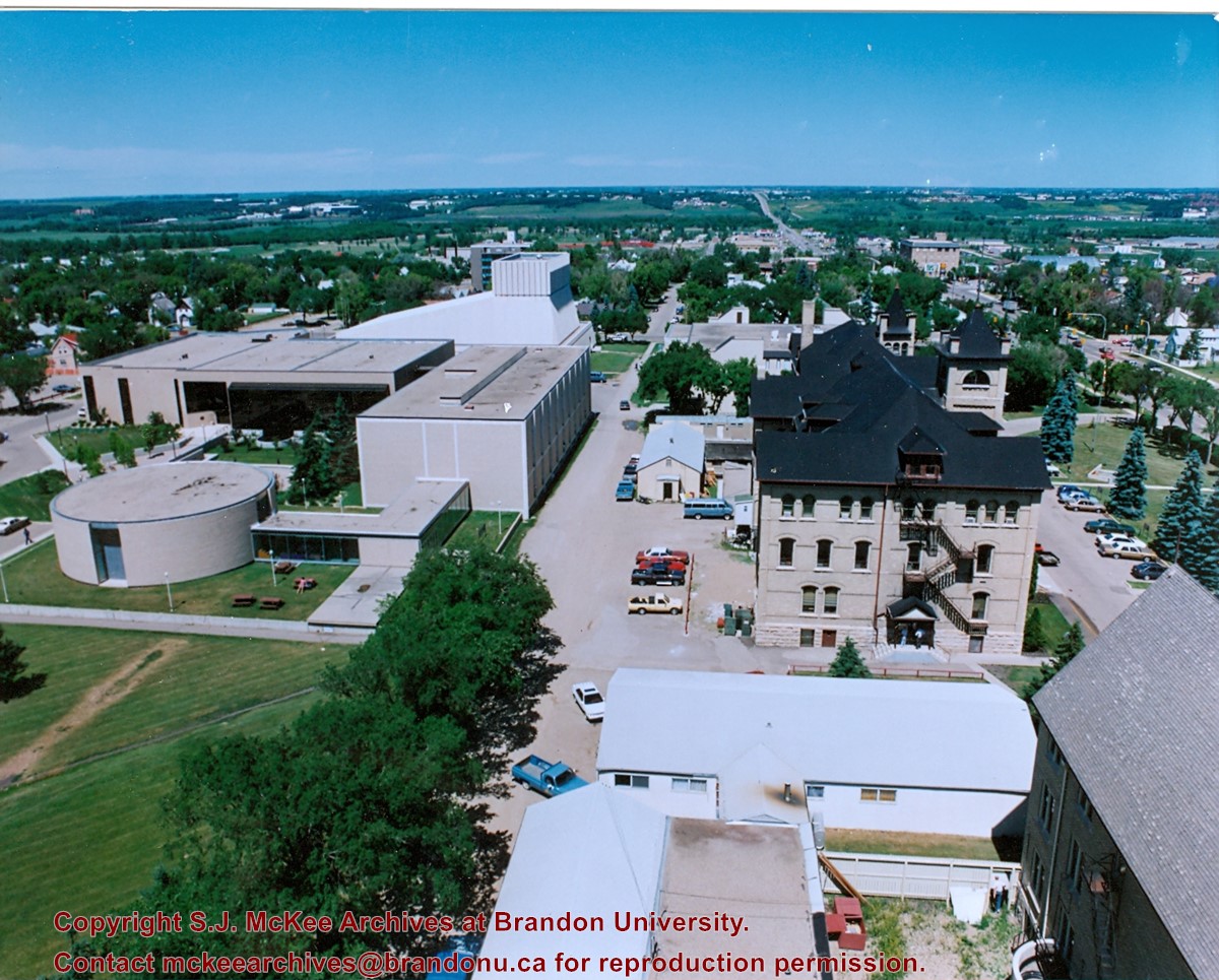
View is east southeast from the roof of the A.E. McKenzie Building. Photograph shows the courtyard and the west side of the Brandon College Building, as well as the Citizens' Science Building and the greenspace in between the two buildings.
Images
Show Less

Brandon University campus

http://archives.brandonu.ca/en/permalink/descriptions8038
Part Of
Aerial views and campus photographs
Description Level
Item
GMD
graphic
Date Range
c. 2000
Part Of
Aerial views and campus photographs
Creator
Photographer: Sandy Black
Description Level
Item
Series Number
2.1
Item Number
2.1.106
GMD
graphic
Date Range
c. 2000
Physical Description
4" x 6" (colour)
Scope and Content
View is from the front steps of the Education Building looking south down the east side of the Brandon College Building and Clark Hall to the Knowles Douglas Students' Union Centre and the John R. Brodie Science Centre in the background.
Images
Show Less

Brandon University campus

http://archives.brandonu.ca/en/permalink/descriptions8251
Part Of
Aerial views and campus photographs
Description Level
Item
GMD
graphic
Date Range
c. 1963
Part Of
Aerial views and campus photographs
Description Level
Item
Series Number
2.1
Item Number
2.1.146
GMD
graphic
Date Range
c. 1963
Physical Description
4" x 5" (b/w)
Scope and Content
View is northwest from the southeast corner of 18th Street and Louise Avenue. Photograph shows the Citizens' Science Building, the Brandon College Building, Clark Hall and two H-Huts, as well as the land to the south of the buildings. The Original Music Building is partially visible in the background.
Images
Show Less

Driveway looking northwest

http://archives.brandonu.ca/en/permalink/descriptions730
Part Of
Aerial views and campus photographs
Description Level
Item
GMD
graphic
Date Range
c. 1963
Part Of
Aerial views and campus photographs
Description Level
Item
Series Number
2.1
Item Number
2.1.144
GMD
graphic
Date Range
c. 1963
Physical Description
3.5" x 5" (colour)
Material Details
Kodak paper
Scope and Content
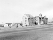
Photograph is looking northwest from approximately the south entrance of the driveway and shows the Citizens' Science Building, the Brandon College Building and part of Clark Hall, as well as the drive way and part of the front lawn.
Images
Show Less

Aerial view: Brandon University campus covered in snow

http://archives.brandonu.ca/en/permalink/descriptions613
Part Of
Aerial views and campus photographs
Description Level
Item
GMD
graphic
Date Range
c. 1970s
Part Of
Aerial views and campus photographs
Description Level
Item
Series Number
2.1
Item Number
2.1.22
GMD
graphic
Date Range
c. 1970s
Physical Description
5" x 3.5" (b/w)
Physical Condition
Photograph is slightly overexposed.
Scope and Content
View is north northwest from the John R. Brodie Science Center (?). Photograph shows: Citizens' Science Building, Brandon College Building and Clark Hall, the Education Building and the driveway running in front of the buildings.
Images
Show Less

Brandon University campus

http://archives.brandonu.ca/en/permalink/descriptions8026
Part Of
Aerial views and campus photographs
Description Level
Item
GMD
graphic
Date Range
c. 1996
Part Of
Aerial views and campus photographs
Description Level
Item
Series Number
2.1
Item Number
2.1.93
GMD
graphic
Date Range
c. 1996
Physical Description
6" x 4" (colour)
Scope and Content
View is east northeast from the sidewalk on the southeast corner of the George T. Richardson Centre (John R. Robbins Library). Photographs shows the campus during winter, including the Physical Plant and Development H-Huts, as well as the Brandon College Building and Clark Hall after the majority of the renovations were completed.
Images
Show Less

Brandon University campus

http://archives.brandonu.ca/en/permalink/descriptions8029
Part Of
Aerial views and campus photographs
Description Level
Item
GMD
graphic
Date Range
c. 1988
Part Of
Aerial views and campus photographs
Description Level
Item
Series Number
2.1
Item Number
2.1.96
GMD
graphic
Date Range
c. 1988
Physical Description
5" x 3.5" (colour)
Scope and Content
View is northwest from the roof of the John R. Brodie Science Centre. Photograph shows part of McMaster Hall, the H-Huts, the Citzens' Science Building, the Brandon College Building and Clark Hall, the driveway, the J.R.C. Evans Lecture Theatre, the A.E. McKenzie Building and the Queen Elizabeth II Music Building.
Images
Show Less

Brandon University campus

http://archives.brandonu.ca/en/permalink/descriptions8036
Part Of
Aerial views and campus photographs
Description Level
Item
GMD
graphic
Date Range
c. 2000
Part Of
Aerial views and campus photographs
Creator
Photographer: Sandy Black
Description Level
Item
Series Number
2.1
Item Number
2.1.104
GMD
graphic
Date Range
c. 2000
Physical Description
6" x 4" (colour)
Scope and Content
View is northeast from the roof of the George T. Richardson Centre (John E. Robbins Library). Photograph shows the courtyard and the west side of the Brandon College building and Clark Hall, as well as the Clark Hall extension and part of the skywalk.
Images
Show Less

Brandon University campus

http://archives.brandonu.ca/en/permalink/descriptions8042
Part Of
Aerial views and campus photographs
Description Level
Item
GMD
graphic
Date Range
c. 1995
Part Of
Aerial views and campus photographs
Description Level
Item
Series Number
2.1
Item Number
2.1.111
GMD
graphic
Date Range
c. 1995
Physical Description
6" x 4" (b/w)
Scope and Content
View is north northeast from the roof of McMaster Hall. Photograph shows a couple of H-Huts, the Brandon College Building, Clark Hall, the George T. Richardson Centre, the A.E. McKenzie Building, the original Music Building and the Western Manitoba Centennial Auditorium. A number of residential blocks are also visible.
Images
Show Less

Aerial view: Citizens' Science Building

http://archives.brandonu.ca/en/permalink/descriptions611
Part Of
Aerial views and campus photographs
Description Level
Item
GMD
graphic
Date Range
c. 1980s
Part Of
Aerial views and campus photographs
Description Level
Item
Series Number
2.1
Item Number
2.1.21
GMD
graphic
Date Range
c. 1980s
Physical Description
5" x 3.5" (b/w)
Scope and Content
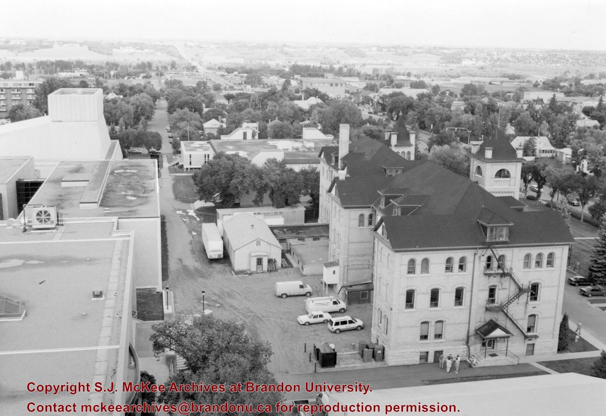
View is northwest, taken from the John R. Brodie Science Centre. Photograph shows: Citizens' Science Building in the foreground, the Brandon College Building and Clark Hall in the background, as well as the driveway in front of the buildings.
Images
Show Less
Part Of
Aerial views and campus photographs
Description Level
Item
GMD
graphic
Date Range
c. 1971
Part Of
Aerial views and campus photographs
Description Level
Item
Series Number
2.1
Item Number
2.1.30
GMD
graphic
Date Range
c. 1971
Physical Description
2.5" x 2.75" (b/w)
Material Details
Contact print
Scope and Content
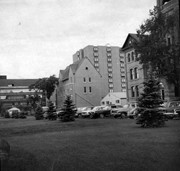
View is southwest and shows a portion of the Brandon College Building, an H-Hut, the Citizens' Science Building, McMaster Hall and the John R. Brodie Science Centre, as well as a number of parked cars. Photograph was taken on the lawn in front of Clark Hall.
Images
Show Less

Brandon University campus

http://archives.brandonu.ca/en/permalink/descriptions8041
Part Of
Aerial views and campus photographs
Description Level
Item
GMD
graphic
Date Range
c. 1988
Part Of
Aerial views and campus photographs
Description Level
Item
Series Number
2.1
Item Number
2.1.110
GMD
graphic
Date Range
c. 1988
Physical Description
5" x 4" (colour)
Scope and Content
View is north northwest from the roof of McMaster Hall. Photograph shows part of the Citizens' Science Building, a number of H-Huts, the Brandon College Building, the greenspace, the J.R.C. Evans Lecture Theatre, the A.E. McKenzie Building, the Queen Elizabeth II Music Building and the Western Manitoba Centennial Auditorium. A number of residential blocks are also visible.
Images
Show Less

A number of campus locations

http://archives.brandonu.ca/en/permalink/descriptions673
Part Of
Aerial views and campus photographs
Description Level
Item
GMD
graphic
Date Range
c. 1965
Part Of
Aerial views and campus photographs
Description Level
Item
Series Number
2.1
Item Number
2.1.147
GMD
graphic
Date Range
c. 1965
Physical Description
3.5" x 5.5" (colour)
Material Details
Postcard
History / Biographical
The Steinway Concert Grand piano on the stage in the Evans Theatre photograph was donated to Brandon College from the Vining estate.
Scope and Content
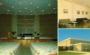
Item consists of images of the interior of the J. R. C. Evans Lecture Theatre, the Dining Room lounge (top right), and the entrance to the Gymnasium (bottom right).
Images
Show Less

A.E. McKenzie Building and George T. Richardson Centre

http://archives.brandonu.ca/en/permalink/descriptions949
Part Of
BUPC 2 Campus buildings
Description Level
Sub-series
GMD
graphic
Date Range
c. 1959 - 1995
Part Of
BUPC 2 Campus buildings
Description Level
Sub-series
Series Number
2.4
GMD
graphic
Date Range
c. 1959 - 1995
Physical Description
43 photographs
History / Biographical
The J.R.C. Evans Lecture Theatre and the A.E. McKenzie Building were both completed in 1960. The Evans Theatre is named for John Robert Charles Evans, who served as president of Brandon College from 1928 to 1959. The A.E. McKenzie Building was originally the Library and Arts building, and was named for A.E. McKenzie, a local businessman and supporter of the College. The George T. Richardson Centre, which includes the Evans Theatre and the John E. Robbins Library, was completed in 1993.
Scope and Content
Sub-series consists of photographs of the A.E. McKenzie Building, the George T. Richardson Centre, the J.R.C. Evans Lecture Theatre, the John E. Robbins Library and the link between the Evans Theatre and the McKenzie Building.
Show Less

Citizens' Science Building and Knowles-Douglas buildings

http://archives.brandonu.ca/en/permalink/descriptions8274
Part Of
BUPC 2 Campus buildings
Description Level
Sub-series
GMD
graphic
Date Range
c.1980s - c.1990s
Part Of
BUPC 2 Campus buildings
Description Level
Sub-series
Series Number
2.3
GMD
graphic
Date Range
c.1980s - c.1990s
Physical Description
5 photographs
History / Biographical
The Citizens' Science Building was built in 1922 and financed by Brandon citizens. It was renamed the Knowles-Douglas Student Union Centre c. 1984 in honour of Brandon College graduates Stanley Knowles and Tommy Douglas, both of the Class of 1930. The Knowles-Douglas Addition was completed in 1987.
Scope and Content
Sub-series consists of photographs of the Citizens' Science Building and the Knowles-Douglas buildings, which include the Knowles-Douglas Student Union Centre and the Knowles-Douglas Addition.
Show Less

John R. Brodie Science Centre

http://archives.brandonu.ca/en/permalink/descriptions8279
Part Of
BUPC 2 Campus buildings
Description Level
Sub-series
GMD
graphic
Date Range
1950s-1982; predominant 1970s
Part Of
BUPC 2 Campus buildings
Description Level
Sub-series
Series Number
2.9
GMD
graphic
Date Range
1950s-1982; predominant 1970s
Physical Description
20 photographs
History / Biographical
The John R. Brodie Science Centre was completed in 1971, with the official opening on May 7, 1972. It is located in the southeast corner of the campus and houses the Faculty of Science. The Brodie Building was named for John R. Brodie, a Brandon man who donated $250,000 to Brandon College in 1963 with the stipulation that the money be used for a Science Centre.
Scope and Content
Sub-series consists of photographs of the John R. Brodie Science Centre.
Notes
Additional biographical information on John R. Brodie is available in his bio file in the Reading Room.
Show Less

Aerial view: Clark Hall, Education Building, Student Union Building

http://archives.brandonu.ca/en/permalink/descriptions612
Part Of
Aerial views and campus photographs
Description Level
Item
GMD
graphic
Date Range
c. 1960s
Part Of
Aerial views and campus photographs
Description Level
Item
Series Number
2.1
Item Number
2.1.17
GMD
graphic
Date Range
c. 1960s
Physical Description
10" x 8" (b/w)
Scope and Content
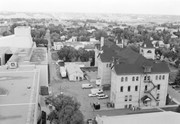
View is northeast, taken from the John R. Brodie Science Centre. Photograph shows: the Brandon College Building, the Student Services H-Hut, the Education Building, and the Student Union Building (Citizens' Science Building), as well as 18th Street and some houses. The trailer to the south of the Education Building was a Canada Manpower office in the 1960s. It was latter moved over by the Gymnasium, where it became the Quill office.
Images
Show Less
Part Of
BUPC 2 Campus buildings
Description Level
Sub-series
GMD
graphic
Date Range
c.1975 - 1981
Part Of
BUPC 2 Campus buildings
Description Level
Sub-series
Series Number
2.13
GMD
graphic
Date Range
c.1975 - 1981
Physical Description
4 photographs
History / Biographical
H-Huts refer to structures built to house military personnel at the Commonwealth Air Training Program just north of Brandon during World War II. The name H-Hut derives from the layout of the structures, which were built in an "H" formation. The original H-Huts were moved onto the Brandon College campus in 1956 to house the library and arts classrooms.. Additional H-Huts have been located in various places and used for various departments and services on campus including Student Services, Continuing Education, and the carpenter's workshop. Only the Physical Plant H-Huts, located to the west of the Knowles-Douglas Student Union Centre, remain on campus in 2007.
Scope and Content
Sub-series consists of photographs of various H-Huts on campus.
Show Less

58 records – page 3 of 3.