Field journals have been scanned in multi-page PDF files. Artifact catalogues are PDF files in spreadsheet format. Photographs are in jpeg format.
History / Biographical
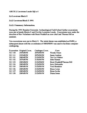
Excavations took place in block E in 1987 and 1988 with 21 units opened. Ten further units were excavated in 1991 as part of the Brandon University Archaeological Field School, directed by Dr. Nicholson with Brett Waddell as crew chief and Theresa Hill as field assistant.
In 1991 a hearth was identified in Block E as well as a cluster of spoil dirt piles believed to represent material from a pit feature identified in the 1988 excavations. The pit feature is believed to be related to the recovery of clay that may have been used to build ceramic vessels.
Stratigraphic evidence of distinct activity areas at successive depths and radiocarbon dates indicate at least three occupations (380 BP, 700 BP and 860 B P). Three identified activity clusters occur stratigraphically, supporting these dated occupations.
Large numbers of lithics were recovered, forming an assemblage dominated by SRC and KRF with lesser amounts of porcellanite and quartzite. The upper occupation contained some Tongue River Silicified Sediment (TRSS). Eight Prairie Side-Notched points were recovered as well as a lunate biface and an end scraper. Fragments from a grey soapstone tube were also recovered.
Scope and Content
Sub-sub-sub series contains: Summary information of field methology, number and co-ordinates of excavations, personnel and their staff position; Field journals are daily records of recoveries, features and activities at the site; Site records include excavation level and unit summaries, feature sheets, profiles; sample records and maps; Artifact catalogues are lists and identifications of all artifacts recovered; Photographs are of excavation units, features, the landscape and personnel.
Field journals have been scanned in multi-page PDF files. Artifact catalogues are PDF files in spreadsheet format. Photographs are in jpeg format.
History / Biographical
Large scale excavations of two block sites took place in 1988 under the direction of Bev Nicholson with Brett Waddell as crew chief and Theresa Hill as assistant. Block E consisted of 10 additional excavation units.
Scope and Content
Sub-sub-sub series contains: Summary information of field methology, number and co-ordinates of excavations, personnel and their staff position.
Site records have been scanned in multi-page PDF files.
History / Biographical
The Crepeele site was excavated in 2003 as Crepeele 3. Standard archaeological methods were used to excavate the units. Site records of excavation units XU 110 – 113 are in seperate pdf files.
Scope and Content
Site records of excavation units may include: level summaries, floor plans, feature sheets, wall profiles, unit summaries and any other additional information relating to the unit.
Field journals have been scanned in multi-page PDF files. Artifact catalogues are PDF files in spreadsheet format. Photographs are in jpeg format.
History / Biographical
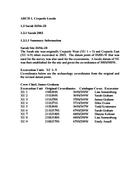
The Sarah site was initially chosen for excavation based on the results of the Casselman survey. The survey recovered significant amounts of faunal remains, some ceramics and lithics from the test pits. Excavations took place in 2003 at Crepeele West (Units 1-5) and Crepeele East (Units 6-9). The site was subsequently renamed the Sarah site DiMe-28.
Units 1 to 9 were excavated by supervisor James Graham and crew of Sarah Graham, Mike Evans, Todd Kristensen, Shayne Kolesar, Lisa Sonnenburg and Emily Ansell.
Scope and Content
Sub-sub-sub series contains: Summary information of field methology, number and co-ordinates of excavations, personnel and their staff position.
Field journals have been scanned in multi-page PDF files. Artifact catalogues are PDF files in spreadsheet format. Photographs are in jpeg format.
History / Biographical
Archaeological testing began in the Crepeele locale in May 2003 with a field crew of four members. James Graham supervised the crew and was assisted by Sarah Graham, Jollana Bishop, and Lisa Sonnenburg. Later additions to the testing team were Todd Kristensen, Michael Evans, and Emily Ansell.
The methodology for this survey used an arbitrary datum and a transit to establish a grid of 30 m intervals and a shovel test every 20 m. Materials were removed and screened to a minimum depth of 50 cm below surface. All recovered materials were bagged and removed to the lab for further analysis. All information including: test pit grid co-ordinates; UTM co-ordinates for each test pit; artifact presence; excavator; vegetation; aspect; paleosol; paleosol depth; and notes, were entered into a GIS database.
Approximately 600 shovel test pits were excavated and recorded in this fashion. Of the 600 shovel test pits, over 300 contained cultural materials. Based on the results of the Casselman survey several areas were designed for further testing and excavation. Crepeele West and Crepeele East were renamed the Sarah site DiMe-28) and Crepeele 3 which became the Crepeele site DiMe- 29.
Scope and Content
Sub-sub-sub series contains: Summary information of field methology, number and co-ordinates of excavations, personnel and their staff position; Field journalsare daily records of recoveries, features and activities at the site; Site records include excavation level and unit summaries, feature sheets, profiles; sample records and maps; Artifact catalogues are lists and identifications of all artifacts recovered; Photographs are of excavation units, features, the landscape and personnel.
Field journals have been scanned in multi-page PDF files. Artifact catalogues are PDF files in spreadsheet format. Photographs are in jpeg format.
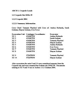
History / Biographical
The Crepeele site was identified from the results of the Casselman survey and excavated in 2003. In 2004 the site was funded through the SCAPE project, directed by Bev Nicholson. The units were excavated by Crew Chief Tomasin Playford and crew.
Eight units were excavated in 2004, XU 1to XU 8
The artifacts recovered from these eight excavations are faunal (animal bone), mainly bison, lithic materials (stone tools and flakes) and some ceramic (pottery). The artifact catalogue has 1258 records.
Scope and Content
Sub-sub-sub series contains: Summary information of field methology, number and co-ordinates of excavations, personnel and their staff position; Field journalsare daily records of recoveries, features and activities at the site; Site records include excavation level and unit summaries, feature sheets, profiles; sample records and maps; Artifact catalogues are lists and identifications of all artifacts recovered; Photographs are of excavation units, features, the landscape and personnel.
Field journals have been scanned in multi-page PDF files. Artifact catalogues are PDF files in spreadsheet format. Photographs are in jpeg format.
History / Biographical
The Crepeele site was identified from the results of the Casselman survey and excavated in 2003. Further units 1 to 8 were excavated in 2004. Funding was through the SCAPE project, directed by Dr. Bev Nicholson. The site was excavated by Crew Chief Tomasin Playford and crew.
Scope and Content
Sub-sub-sub series contains: Summary information of field methology, number and co-ordinates of excavations, personnel and their staff position.
Field journals have been scanned in multi-page PDF files.
History / Biographical
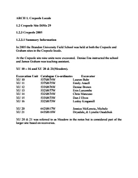
In 2005 the Brandon University Field School was held at both the Crepeele and Graham sites in the Crepeele locale.
At the Crepeele site nine units were excavated (XU10-16 & 20, 21). Units 20 & 21 were referred to as Meadow in the notes but are considered part of the larger site based on recoveries.
Denise Ens instructed the school and James Graham was teaching assistant. Field journals were kept by both instructors.
Scope and Content
Record of daily observations at the site including: excavation methods, items recovered, features, local environment and weather.
Site records have been scanned in multi-page PDF files.
History / Biographical
The Crepeele site was identified from the results of the Casselman survey and excavated in 2003. In 2004 the site was funded through the SCAPE project, directed by Bev Nicholson. The units were excavated by Crew Chief Tomasin Playford and crew.
Eight units were excavated in 2004, XU 1 to XU 8. Each unit has a seperate pdf file.
Scope and Content
Site records of excavation units may include: level summaries, floor plans, feature sheets, wall profiles, unit summaries and any other additional information relating to the unit.
Field journals have been scanned in multi-page PDF files. Artifact catalogues are PDF files in spreadsheet format. Photographs are in jpeg format.
History / Biographical
The Crepeele site was identified from the results of the Casselman survey and excavated in 2003 and 2004.
In 2005 the Brandon University Field School was held at both the Crepeele and Graham sites in the Crepeele locale. Denise Ens instructed the school and James Graham was teaching assistant.
At the Crepeele site nine units were excavated (XU10-16 & 20, 21). Units 20 & 21 were referred to as Meadow in the notes but is considered part of the larger site based on recoveries. There are over 1,570 records in the catalogue. Faunal (animal bone), lithics, fire cracked rock, diagnostic lithics and ceramics were recovered from the site
The weather conditions during the field school were particularly difficult due to the rainfall and flooding of the roads and sites.
Scope and Content
Sub-sub-sub series contains: Summary information of field methology, number and co-ordinates of excavations, personnel and their staff position; Field journalsare daily records of recoveries, features and activities at the site; Site records include excavation level and unit summaries, feature sheets, profiles; sample records and maps; Artifact catalogues are lists and identifications of all artifacts recovered; Photographs are of excavation units, features, the landscape and personnel.
Field journals have been scanned in multi-page PDF files. Artifact catalogues are PDF files in spreadsheet format. Photographs are in jpeg format.
History / Biographical
In 2005 the Brandon University Field School was held at both the Crepeele and Graham sites in the Crepeele locale. Denise Ens instructed the school and James Graham was teaching assistant.
Nine units were excavated (XU10-16 & 20, 21). Units 20 & 21 were referred to as Meadow in the notes but are considered part of the larger site based on recoveries
Faunal (animal bone), lithics, fire cracked rock, diagnostic lithics and ceramics were recovered from the site.
Scope and Content
Sub-sub-sub series contains: Summary information of field methology, number and co-ordinates of excavations, personnel and their staff position.
Site records have been scanned in multi-page PDF files.
History / Biographical
In 2005 the Brandon University Field School was held at both the Crepeele and Graham sites in the Crepeele locale.
Denise Ens instructed the school and James Graham was teaching assistant.
At the Crepeele site nine units were excavated (XU10-16 & 20, 21). Units 20 & 21 were referred to as Meadow in the notes but are considered part of the larger site based on recoveries
Scope and Content
Site records of excavation units may include: level summaries, floor plans, feature sheets, wall profiles, unit summaries and any other additional information relating to the unit.
Field journals have been scanned in multi-page PDF files. Artifact catalogues are PDF files in spreadsheet format. Photographs are in jpeg format.
History / Biographical
The Crepeele site was identified from the results of the Casselman survey and excavated in 2003, 2004 and 2005.
In 2007 the Brandon University Archaeology Field School was held at the Crepeele site in the Crepeele locale. Denise Ens instructed the school with Kate Decter & Jessica MacKenzie assistants.
Seventeen units were excavated XU30 - 46. Faunal (animal bone), lithics, fire cracked rock, diagnostic lithics and ceramics were recovered from the site. There are over 3050 records in the catalogue.
Scope and Content
Sub-sub-sub series contains: Summary information of field methology, number and co-ordinates of excavations, personnel and their staff position; Field journalsare daily records of recoveries, features and activities at the site; Site records include excavation level and unit summaries, feature sheets, profiles; sample records and maps; Artifact catalogues are lists and identifications of all artifacts recovered; Photographs are of excavation units, features, the landscape and personnel.
Field journals have been scanned in multi-page PDF files. Artifact catalogues are PDF files in spreadsheet format. Photographs are in jpeg format.
History / Biographical
The Crepeele site was identified from the results of the Casselman survey and excavated in 2003, 2004, 2005 and 2007.
In 2005 and 2007 the Brandon University Archaeology Field School was held at the Crepeele site in the Crepeele locale.
In 2008 a small crew returned to the site to gather further samples and verify profiles. Three units (XU 50, 51 and 52) were excavated with faunal (animal bone), lithics, fire cracked rock, diagnostic lithics and ceramics recovered from the site. There are 455 records in the artifact catalogue.
Scope and Content
Sub-sub-sub series contains: Summary information of field methology, number and co-ordinates of excavations, personnel and their staff position.
Field journals have been scanned in multi-page PDF files.
History / Biographical
In 2007 the Brandon University Archaeology Field School was held at the Crepeele site in the Crepeele locale. Denise Ens instructed the school with Kate Decter & Jessica MacKenzie assistants.
Seventeen units were excavated XU30 - 46. Faunal (animal bone), lithics, fire cracked rock, diagnostic lithics and ceramics were recovered from the site. There are over 3050 records in the catalogue.
Scope and Content
Record of daily observations at the site including: excavation methods, items recovered, features, local environment and weather.
Field journals have been scanned in multi-page PDF files. Artifact catalogues are PDF files in spreadsheet format. Photographs are in jpeg format.
History / Biographical
After the flooding of the Souris River in 2004 receded, Tomasin Playford and her crew of Andrea Richards, Sarah Graham and Shane Kolesar returned to the Atkinson site and commenced cleaning up the earlier excavation of Atkinson.
An area east of the Atkinson excavations was also opened for testing in 2004. This area was designated as Atkinson II. In some of the field notes it is referred to as Atkinson East. A test block was opened and fenced off from the cattle with snow fence. A 4m2 block was surveyed in (units 13 - 16) and two partial units that were truncated by the riverbank (units 11 &12) were also placed to the south of the 4m2 block.
Three of the students who had completed the recent field school were hired as crew. Jessica McKenzie, Evie Fevez and Emily Ansell joined the crew at the Atkinson II site.
Recoveries from XU 13 - 16:
Large bison bone was recovered from units 11 and 12 and a metal tobacco box seal was recovered from unit 12. More small pieces of metal found in levels 2 and three together with small bone fragments. A bone fragment with butchering marks from a metal tool was recovered from level 6 and pottery was found in level 9. A few lithic flakes were found in level 13 and in a trench at the bottom of unit 13 above a calcite cemented layer. Recoveries from these tests were sparse and diminished as the excavation series became more distant from the river. It is likely that the remains that were recovered represent the northern edge of these occupations.
The upper occupation at Atkinson II appears to be an early historic occupation with a sparse scatter of bone and a few pieces of metal. The lower layers, below level 7 are likely precontact. Units 9 and 10 were dug as test pits and produced very little in the way of cultural materials.
Scope and Content
Sub-sub-sub series contains: Summary information of field methology, number and co-ordinates of excavations, personnel and their staff position; Field journals are daily records of recoveries, features and activities at the site; Site records include excavation level and unit summaries, feature sheets, profiles; sample records and maps; Artifact catalogues are lists and identifications of all artifacts recovered; Photographs are of excavation units, features, the landscape and personnel.
Field journals have been scanned in multi-page PDF files. Artifact catalogues are PDF files in spreadsheet format. Photographs are in jpeg format.
History / Biographical
The Atkinson site had been flooded in 2005 and there was concern about the amount of damage that might have occurred. A small crew of Tomasin Playford, Michelle Drysdale and Jessica McKenzie returned to the Atkinson site with the goals of obtaining a detailed profile of the stratigraphy at the north end of the occupation and to determine if the site extended contiguously towards the east. Two test pits were planned as well as the investigation of a couple of hearths found eroding from the riverbank Work commenced July 4th and finished July 21st.
To the north of XU 8 (Gowen occupation) an excavation unit 18 was opened and shovel shaved to a depth of 200cm. At 195cm below surface a point bar deposit was identified indicating that any lower occupations would likely have been eroded by an earlier channel cutting event prior to formation of this point bar depositional event. Golf tees were inserted into the edge of the profile to indicate the 5cm levels superimposed on a digital photo of the section. Lithic flakes and bone fragments were scattered thoughout the stratigraphic column. A radiocarbon date of 440 B.P. was obtained from the unit, indicating a much later occupation than Gowen.
Unit 19 was excavated but only yielded a small Besant component containing a small hearth (H#3) In level 9, a point tip and a small biface as well as a few undecorated pot sherds were recovered. These two units defined the extent of the Atkinson I site. An unknowable area of the site has been eroded away by the encroaching Souris River.
The two small exposed hearths were excavated but only yielded a small amount of material. Hearth 4, at the western edge of the Atkinson block yielded only a small amount of charcoal , mixed with burnt bone and a few small lithic flakes. Hearth 5, located in the high cut bank west of the main site yielded a small amount of bone from a small ungulate, a muskrat and a bird as well as a percussion cap. This latter recovery indicated that this was an early historic period site.
Scope and Content
Sub-sub-sub series contains: Summary information of field methology, number and co-ordinates of excavations, personnel and their staff position; Field journals are daily records of recoveries, features and activities at the site; Site records include excavation level and unit summaries, feature sheets, profiles; sample records and maps; Artifact catalogues are lists and identifications of all artifacts recovered; Photographs are of excavation units, features, the landscape and personnel.
Flintstone Hill is located on the north bank of the Souris River. It is a deeply stratified lacustrine, fluvial and aeolian soil profile that has been exposed by the river through stream-bank erosion. This section is thought to be the most complete middle to late Holocene exposure on the northeastern plains. While the value of the site is primarily for paleo-environmental research and reconstruction, cultural deposits have been identified at the site. Local collectors have picked up lithic materials as they eroded out of the bank for the past several decades and it was they who had named the site. Mr. Bruce Timms from Lauder first drew the Flintstone Hill site to the attention of Dr. Nicholson of Brandon University.
During the mid 1990’s to the early 2000’s archaeological testing took place on Flintstone Hill. In 1998, an archaeological field crew dug a series of overlapping trenches down the slope of the profile and produced a schematic drawing. A peat layer at the bottom of this profile, dated from the top at 9,400 RCY and at the bottom to 10,400 RCY, has provided details of marsh plant and insect communities at this time.
Subsequent archaeological investigations at the site recovered several cultural deposits including: a hearth dating to 3250+/-70 R.C.Y. (BETA 109529); a butchered atlas bone 4090+/-70 R.C.Y. (BETA 109990); and bone fragments accompanied by Swan River Chert and Knife River Flint lithic flakes 5350+/-50 (BETA 109530). While no diagnostic tools were recovered, these dates suggest that this occupation, which is contemporary with the Atkinson site, may be a Gowen occupation.
Extensive paleo-environmental research has been conducted at the site. Dr. Running, a geomorphologist from the University of Wisconsin – Eau Claire, participated in the Study of Cultural Adaptations in the Prairie Ecozone (SCAPE) Project and he and his students tested the site for several years. He was joined in this effort by Dr. Havholm, Dr. Boyd, Dr. Wiseman, Dr. Beaudoin, and other SCAPE researchers in the interpretation of the paleo-environment of the Glacial Lake Hind basin. The following article is recommended reading.
Running, Garry L., Karen G. Havholm, Matt Boyd and Dion J. Wiseman
2002 Holocene Stratigraphy and Geomorphology of Flintstone Hill, Lauder Sandhills, Glacial Lake Hind Basin, Southwestern Manitoba. Geographie Physique et Quaternaire
56(2-3):291-303.
Scope and Content
Sub series has been divided into two sub sub series including: (1) Flintstone Hill 1997 (2) Flintstone Hill 1998-2000
Field journals have been scanned in multi-page PDF files. Artifact catalogues are PDF files in spreadsheet format. Photographs are in jpeg format.
History / Biographical
During the mid 1990’s to the early 2000’s archaeological surveying and testing took place on Flintstone Hill. In 1997 testing at the site revealed a bison skull eroding from the cutbank. A field crew dug a series of overlapping trenches down the slope of the profile and produced a schematic drawing. A radiocarbon date from the lower edge of the profile gave a date of 10,400 RCY.
Test units along the cutbank recovered lithics, soil samples, fire-cracked rock, charcoal, bison remains including a very large bison skull measuring 430-440 cm and thought to be an ancient species.
Radiocarbon dates at Flintstone hill gave dates of: a hearth dating to 3250+/-70 R.C.Y. (BETA 109529); a butchered atlas bone 4090+/-70 R.C.Y. (BETA 109990); and bone fragments accompanied by Swan River Chert and Knife River Flint lithic flakes 5350+/-50 (BETA 109530). While no diagnostic tools were recovered, these dates suggest that this occupation, which is contemporary with the Atkinson site, may be a Gowen occupation.
Scope and Content
Sub-sub-sub series contains: Summary information of field methology, number and co-ordinates of excavations, personnel and their staff position; Field journals are daily records of recoveries, features and activities at the site; Site records include excavation level and unit summaries, feature sheets, profiles; sample records and maps; Artifact catalogues are lists and identifications of all artifacts recovered; Photographs are of excavation units, features, the landscape and personnel.
Field journals have been scanned in multi-page PDF files. Artifact catalogues are PDF files in spreadsheet format. Photographs are in jpeg format.
History / Biographical
In 1998, 1999 and 2000 further testing took place on Flintstone Hill. Five test units were excavated and a series of small exploratory tests took place. Recoveries included: lithics, soil samples, fire-cracked rock, charcoal, and bison bones.
Unfortunately, despite the encouraging radiocarbon dates and scattered recoveries there was no area where extensive excavations were feasible. The unstable nature of the river bank with frequent spring flooding and erosion of the dunes has impacted potential sites.
Scope and Content
Sub-sub-sub series contains: Summary information of field methology, number and co-ordinates of excavations, personnel and their staff position; Field journals are daily records of recoveries, features and activities at the site; Site records include excavation level and unit summaries, feature sheets, profiles; sample records and maps; Artifact catalogues are lists and identifications of all artifacts recovered; Photographs are of excavation units, features, the landscape and personnel.