The Specialty Shop [to the right of the "OK Used Cars" sign] was opened by Ms. Helen Lamont in 1953.
Custodial History
For custodial history see the collection level description of the Lawrence Stuckey collection.
Scope and Content
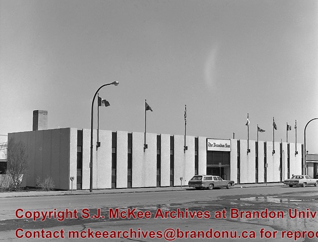
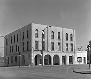
This image shows commercial buildings located on the east side of the 100 block of 10th Street.
Businesses shown include Western Motors automobile dealership and a Specialty Shop
Notes
[Mr. Stuckey put three negatives and three prints in same envelope. We have separated them and numbered the negatives EA3(1), EA3(2) and EA3(3), and the prints EA3(1a), EA3(2a), EA3(3a).]
For custodial history see the collection level description of the Lawrence Stuckey collection.
Scope and Content
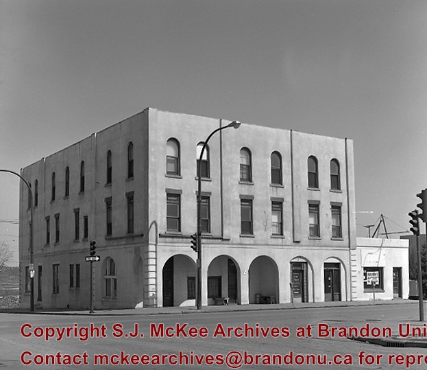
This image shows various commercial buildings located on the east side of the 100 block of 10th Street.
Businesses shown include the Bank of Montreal, Barclay's Shoe Store, Carlton Cafe, and Ted Heming Jewellers
Notes
[Mr. Stuckey put three negatives and three prints in same envelope. We have separated them and numbered the negatives EA3(1), EA3(2) and EA3(3), and the prints EA3(1a), EA3(2a), EA3(3a).]
For custodial history see the collection level description of the Lawrence Stuckey collection.
Scope and Content
This image shows commercial buildings located on the west side of the 100 block of 10th Street.
Businesses shown include Bottomley's, Recreation Bowling and Billiards, and Brandon News & Record Shop.
Notes
[Mr. Stuckey put three negatives and three prints in same envelope. We have separated them and numbered the negatives EA4(1) through EA4(3), and the prints EA4(1a) through EA4(3a).]
Photograph has pen markings and publishing mark-up notes on front and back of matting
Scope and Content
Photograph shows the north side of the 900-block of Rosser Avenue, facing west from 9th Street. All the shops appear to be woodframed buildings; the sidewalk has yet to be installed and wooden planks have been laid down in front of the shops. Visible storefronts include: (left to right): Leask & Rose, general merchants (at the 11th Street intersect); Fortier & Bucke - Manufacturers' Agents and CPR Express Co.; The New Era - real estate office; Imperial Bank of Canada; Durand & Macdonald Law Office, T.D. McLean - jeweller; Deacon & Hooper - grocers; and J. Barker Vosburgh - Surgeon & Dentist. The building in the foreground has Rosser Avenue and 9th Street street signs affixed above the entrance to the building. A chuckwagon is parked in front of Fortier & Bucke.
Notes
Writing on the front of the photograph reads: Brandon.
Postcard is of buildings at Brandon University, including Clark Hall and the Original Building prior to the renovations, McMasater Hall, and the Q.E.II School of Music building.
Notes
Writing on the front of the postcard reads: Brandon University. Back of the postcard reads: (Top Left) Brandon University original building (Administration Center.), Bottom Left) Queen Elizabeth II Music Building, (Right) McMaster Hall Residence; Photo by Sandy Black; Printed in Brandon, Manitoba, Canada, by Leech Printing Ltd.
Photograph shows a panorama, bird's-eye-view of downtown Brandon, between Pacific and Rosser Avenues and 7th Street facing east. Photoraph likely taken from the McKenzie Seeds Building. Visible businesses include: Western Canada Flour Mills, Hanbury Hardware Co. Ltd., Cockshutt Plow Co., New Pacific Hotel, Gordon McKay Building, and Arlington Hotel.
Notes
Part of "Souvenir of Brandon, Manitoba, Canada [viewbook], Printed by Photogelatine Engraving Co. Limited, Ottawa." Dates obtained from the Burchill's Music Store Henderson's Brandon City Directory listings (1927-1929). Writing on the front of the photograph reads: Panorama of Brandon, Man.
Photograph shows the exterior of the Winter Fair Arena on 10th Street.
Notes
Part of "Souvenir of Brandon, Manitoba, Canada [viewbook], Printed by Photogelatine Engraving Co. Limited, Ottawa." Dates obtained from the Burchill's Music Store Henderson's Brandon City Directory listings (1927-1929). Writing on the front of the photograph reads: Winter Fair Arena, Brandon, Man.
Photograph shows the CPR Train Station on Pacific Avenue and 10th Street.
Notes
Part of "Souvenir of Brandon, Manitoba, Canada [viewbook], Printed by Photogelatine Engraving Co. Limited, Ottawa." Dates obtained from the Burchill's Music Store Henderson's Brandon City Directory listings (1927-1929). Writing on the front of the photograph reads: CPR Station, Brandon, Man.
Photograph shows a southwest view of the Prince Edward Hotel and train station.
Notes
Part of "Souvenir of Brandon, Manitoba, Canada [viewbook], Printed by Photogelatine Engraving Co. Limited, Ottawa." Dates obtained from the Burchill's Music Store Henderson's Brandon City Directory listings (1927-1929). Writing on the front of the photograph reads: Prince Edward Hotel, Brandon, Man.
The Medicine Hat Exhibition and Stampede Parade Day was held on Thursday, July 19, 1962, at 9:30 a.m. The local newspaper reported that approximately 24,000 people were in attendance to see parade marshall Rod Ashburner leading 175 entries consisting of 90 floats, 75 horses, and 10 bands. There were 19 parade categories eligible for $12,000 in prize money and included: junior and senior cowboys and cowgirls; fancy and Shetland ponies; sulky class open; comic, commercial, industrial and organizational floats; decorated cars; special ranch class; 4-H Clubs; and a non-competitive class.
The parade route started at Second St. and Allowance Ave., from Second St. to Ash Ave., north on Ash to First St. SE., from First St. S.E. to Fourth Ave., south to Second St. to South Railway St., south on South Railway St. to Third St., with a finish at McLeod Trail. A route map was published in the Medicine Hat News the day before the parade.
Aerial photographs of the parade were taken by Medicine Hat News photographer Howard Heid (1930-2005) from the private helicopter of John Bourn. Bourn was a pilot from Woodville, Wisconsin, who chartered his four-seater helicopter for sight-seers at exhibitions and stampedes across the county.
(Sources: Pat Currie, "Let 'Er Go!," Medicine Hat News, 19 July 1962,1; Harald Gunderson, "'Eye in the Sky' Best Parade View," Medicine Hat News, 19 July 1962,1; "Parade Starts at 9:30 Sharp," 18 July 1962)
Scope and Content
Photograph shows an aerial view of the Medicine Hat Exhibition and Stampede Parade route with a focus on the First Street SE and Sixth Avenue intersection. A number of gas stations and garages are visible along this route and include Texaco, Shell, Ford, and B/A. A number of observers can be seen sitting on rooftops.
Notes
This photograph shows the neighbourhood before rezoning and commercial development.
The Medicine Hat Exhibition and Stampede Parade Day was held on Thursday, July 19, 1962, at 9:30 a.m. The local newspaper reported that approximately 24,000 people were in attendance to see parade marshall Rod Ashburner leading 175 entries consisting of 90 floats, 75 horses, and 10 bands. There were 19 parade categories eligible for $12,000 in prize money and included: junior and senior cowboys and cowgirls; fancy and Shetland ponies; sulky class open; comic, commercial, industrial and organizational floats; decorated cars; special ranch class; 4-H Clubs; and a non-competitive class.
The parade route started at Second St. and Allowance Ave., from Second St. to Ash Ave., north on Ash to First St. SE., from First St. S.E. to Fourth Ave., south to Second St. to South Railway St., south on South Railway St. to Third St., with a finish at McLeod Trail. A route map was published in the Medicine Hat News the day before the parade.
Aerial photographs of the parade were taken by Medicine Hat News photographer Howard Heid (1930-2005) from the private helicopter of John Bourn. Bourn was a pilot from Woodville, Wisconsin, who chartered his four-seater helicopter for sight-seers at exhibitions and stampedes across the county.
(Sources: Pat Currie, "Let 'Er Go!," Medicine Hat News, 19 July 1962,1; Harald Gunderson, "'Eye in the Sky' Best Parade View," Medicine Hat News, 19 July 1962,1; "Parade Starts at 9:30 Sharp," 18 July 1962)
Scope and Content
Photograph shows an aerial view of the Medicine Hat Exhibition and Stampede Parade route, with a focus on Second Street SE. Visible store signs include: Gardener's Used Cars, Provincial Treasury Branch, Furvey's Furniture and Appliances, J.J. Moore & Son Furniture, Alberta Credit Jewellers, James Richardson & Sons, Medicine Hat Gas Power Water City Owned Utilities.
Notes
This photograph shows the neighbourhood before rezoning and commercial development.
.jpg?width=1200&404=no-img.jpg&watermark=wmk)
.jpg?width=180&404=no-img.jpg)
.jpg?width=1200&404=no-img.jpg&watermark=wmk)
.jpg?width=180&404=no-img.jpg)
.jpg?width=1200&404=no-img.jpg&watermark=wmk)
.jpg?width=180&404=no-img.jpg)
.jpg?width=1200&404=no-img.jpg&watermark=wmk)
.jpg?width=180&404=no-img.jpg)
.jpg?width=1200&404=no-img.jpg&watermark=wmk)
.jpg?width=180&404=no-img.jpg)
.jpg?width=1200&404=no-img.jpg&watermark=wmk)
.jpg?width=180&404=no-img.jpg)
.jpg?width=1200&404=no-img.jpg&watermark=wmk)
.jpg?width=180&404=no-img.jpg)
.jpg?width=1200&404=no-img.jpg&watermark=wmk)
.jpg?width=180&404=no-img.jpg)


.jpg%3fmaxheight%3d1000%26maxwidth%3d1000%26watermark%3dwmk&description=10th+Street+Businesses+-+East+Side+of+100+Block)
.jpg%3fmaxheight%3d1000%26maxwidth%3d1000%26watermark%3dwmk&description=10th+Street+Businesses+-+East+Side+of+100+Block)
.jpg%3fmaxheight%3d1000%26maxwidth%3d1000%26watermark%3dwmk&description=10th+Street+Businesses+-+East+Side+of+100+Block)
.jpg%3fmaxheight%3d1000%26maxwidth%3d1000%26watermark%3dwmk&description=10th+Street+Businesses+-+East+Side+of+100+Block)
.jpg%3fmaxheight%3d1000%26maxwidth%3d1000%26watermark%3dwmk&description=10th+Street+Businesses+-+West+Side+of+100+Block)
.jpg%3fmaxheight%3d1000%26maxwidth%3d1000%26watermark%3dwmk&description=10th+Street+Businesses+-+West+Side+of+100+Block)
.jpg%3fmaxheight%3d1000%26maxwidth%3d1000%26watermark%3dwmk&description=10th+Street+Businesses+-+West+Side+of+100+Block)
.jpg%3fmaxheight%3d1000%26maxwidth%3d1000%26watermark%3dwmk&description=10th+Street+Businesses+-+West+Side+of+100+Block)