Skip header and navigation

Revise Search

20 records – page 1 of 1.

Parade on 10th Street

http://archives.brandonu.ca/en/permalink/descriptions14253
Part Of
Joseph H. Hughes collection
Description Level
Item
GMD
graphic
Date Range
1924
Accession Number
3-1997
Part Of
Joseph H. Hughes collection
Creator
Photographer: C.J. Smith
Description Level
Item
Series Number
3-1997.1
Item Number
3-1997.1.62
Accession Number
3-1997
Other Numbers
Hughes #63
GMD
graphic
Date Range
1924
Physical Description
7.5" x 9.5" (b/w)
Material Details
on matting
Physical Condition
Mat is scuffed
History / Biographical
The Brandon Daily Sun (26 May 1924, 16) reported the annual church parade of Brandon Lodge 173 Sons of England was held on Sunday, May 25, 1924. The Brandon City Band lead the parade with H.J. Barter, P.P., serving as parade marshal. Over 100 members paraded to St. Mary's Church. Representatives from a variety of lodges participated, including Alexander, Neepawa, Souris, Wawanesa, and Lodge Carpenter Juveniles.
Scope and Content
Photograph shows a parade travelling southwards on 10th Street between Rosser and Princess Avenues. A mounted rider wearing white appears to be leading the parade. A car draped with American and British flags follows. A band follows the vehicle. Individuals wearing white hats walk up the street. Business visible on the west side (100-block) of 10th Street include: Doig, Rankin, & Robertson, Limited; Bowling Alley, Billiards; Olympia Cafe Candies. The second storey on the Hughes Building has not been erected. The Alexandra Block, Strathcona Block, Olympia Block are visible. A large Union Jack flys from the Canadian Pacific Station. Vehicles are diagonally parked on both sides of 10th Street.
Notes
Back of photograph is stamped: Hughes & Co. Ltd., 1009 Princess Ave., Brandon, Man. Date for photograph obtained from licence plates.
Name Access
Doig, Rankin & Robertson
Olympia Cafe
Hughes Building
Alexandra Block
Strathcona Block
10th Street
Subject Access
parades
Brandon business buildings & facilities before 1940
cafes
street scenes
Storage Location
Hughes oversize drawer
Images
Show Less

9th Street aerial view facing south, Brandon, Manitoba

http://archives.brandonu.ca/en/permalink/descriptions8419
Part Of
Joseph H. Hughes collection
Description Level
Item
GMD
graphic
Date Range
c. 1940
Accession Number
3-1997
Part Of
Joseph H. Hughes collection
Creator
Photographer: Jerrett Photo
Description Level
Item
Series Number
3-1997.1
Item Number
3-1997.1.41
Accession Number
3-1997
GMD
graphic
Date Range
c. 1940
Physical Description
5.5" x 3.5" (b/w)
Material Details
postcard
Physical Condition
good
Scope and Content
Postcard shows an aerial view of 9th Street facing south in Brandon, Manitoba. Visible businesses and landmarks include: Beaubier Hotel, YMCA/police station, the original CKX Radio station towers on 8th Street (est. 1928 - moved 1940), the old City Hall, Prince Edward Hotel, and the original Manitoba Power commission smokestack on 10th Street.
Notes
Writing on the front of the photograph reads: Brandon, Man., Jerrett Photo. This photograph shows a rare view of the 800-block between Rosser and Princess Avenues.
Name Access
Beaubier Hotel
City Hall
CKX
Prince Edward Hotel
Manitoba Power Company
Subject Access
downtowns
street scenes
Brandon business buildings & facilities before 1940
aerial views
building exteriors
Storage Location
RG 5 photograph storage drawer
Images
Show Less

Aerial view of 10th Street facing south from Princess Avenue

http://archives.brandonu.ca/en/permalink/descriptions8420
Part Of
Joseph H. Hughes collection
Description Level
Item
GMD
graphic
Date Range
c.1940
Accession Number
3-1997
Part Of
Joseph H. Hughes collection
Creator
Photographer: Jerrett Photo
Description Level
Item
Series Number
3-1997.1
Item Number
3-1997.1.42
Accession Number
3-1997
GMD
graphic
Date Range
c.1940
Physical Description
5.5" x 3.5" (b/w)
Material Details
postcard
Physical Condition
Red ink stain is on the front right corner of postcard
Scope and Content
Photograph shows 10th Street facing south from Princess Avenue. Visible landmarks and businesses include: Manitoba Power Commission (MPC)'s power sub-station, First Baptist Church, Wheat City Arena, and the grand stand at the Exhibition Grounds. The partial sign visible at the bottom of the photograph on the east side of 10th Street reads Yates and Neale, which refers to a plumbing and heating company that dissolved in 1943 to be replaced by Neale, Stothard and Chapman. Businesses on the west side of 10th Street include: Dominion Tire & Radio Co., Bolts Barber Shop, Elviss T.E. Co. Stables.
Notes
Information concerning Yates and Neale courtesy Jack Stothard. Writing on the front of the postcard reads: Brandon, Looking S.W., Jerrett Photo. This photograph shows a rare view of the 200-block of 10th Street.
Name Access
Manitoba Power Company
10th Street
Dominion Tire & Radio Co.
T.E. Elviss Co. Stables
First Baptist Church
Subject Access
downtowns
street scenes
Brandon business buildings & facilities before 1940
aerial views
building exteriors
residences
churches
Storage Location
RG 5 photograph storage drawer
Images
Show Less

Red Indian Station (Gasoline) north side Princess Avenue between 9th Street and 10th Street, Brandon, Manitoba

http://archives.brandonu.ca/en/permalink/descriptions8418
Part Of
Joseph H. Hughes collection
Description Level
Item
GMD
graphic
Date Range
c. 1940
Accession Number
3-1997
Part Of
Joseph H. Hughes collection
Description Level
Item
Series Number
3-1997.1
Item Number
3-1997.1.40
Accession Number
3-1997
GMD
graphic
Date Range
c. 1940
Physical Description
10" x 8" (b/w)
Physical Condition
good
Scope and Content
Photograph shows the Red Indian (Gasoline) Station on the north side Princess Avenue between 9th and 10th Streets, Brandon. Attached to the west side of the gas station is another shop which contains Hutchings' Drug Store. The Alexandra Block on 10th Street is visible in the background.
Name Access
Hutchings Drugs
Red Indian Service Station
Princess Avenue
Subject Access
downtowns
street scenes
Brandon business buildings & facilities after 1940
building exteriors
garages
drug stores
Storage Location
RG 5 photograph storage drawer
Images
Show Less

Greyhound Bus Depot, 11th Street and Princess Avenue, Brandon, Manitoba

http://archives.brandonu.ca/en/permalink/descriptions8414
Part Of
Joseph H. Hughes collection
Description Level
Item
GMD
graphic
Date Range
c.1955
Accession Number
3-1997
Part Of
Joseph H. Hughes collection
Description Level
Item
Series Number
3-1997.1
Item Number
3-1997.1.36
Accession Number
3-1997
GMD
graphic
Date Range
c.1955
Physical Description
10" x 8" (b/w)
Physical Condition
good
Scope and Content
Photograph shows the Greyhound Bus Depot at 11th Street and Princess Avenue. Western Motors, Wheelers Esso Station, and the Prince Edward Hotel are visible along the south side of Princess Avenue. Traffic is travelling one-way on Princess Avenue.
Name Access
Greyhound
Western Motors Ltd.
Esso
Prince Edward Hotel
Princess Avenue
11th Street
Subject Access
downtowns
street scenes
Brandon business buildings & facilities after 1940
building exteriors
hotels
garages
bus depots
Storage Location
RG 5 photograph storage drawer
Images
Show Less

Western Motors at southwest corner 10th and Princess Avenue, Brandon, Manitoba

http://archives.brandonu.ca/en/permalink/descriptions8415
Part Of
Joseph H. Hughes collection
Description Level
Item
GMD
graphic
Date Range
c.1955
Accession Number
3-1997
Part Of
Joseph H. Hughes collection
Description Level
Item
Series Number
3-1997.1
Item Number
3-1997.1.37
Accession Number
3-1997
GMD
graphic
Date Range
c.1955
Physical Description
10" x 8" (b/w)
Physical Condition
good
Scope and Content
Photograph shows Western Motors Ltd. on the southwest corner of 10th Street and Princess Avenue. To the west of the car dealership/garage is the Greyhound Bus Station and its Maxwell House Cafe as well as the court house.
Name Access
Greyhound
Western Motors Ltd.
Princess Avenue
Maxwell House Grill
Court House
Subject Access
downtowns
street scenes
Brandon business buildings & facilities after 1940
building exteriors
winter
bus depots
garages
Storage Location
RG 5 photograph storage drawer
Images
Show Less

Western Motors Ltd., Brandon, Manitoba

http://archives.brandonu.ca/en/permalink/descriptions8411
Part Of
Joseph H. Hughes collection
Description Level
Item
GMD
graphic
Date Range
c. 1950
Accession Number
3-1997
Part Of
Joseph H. Hughes collection
Description Level
Item
Series Number
3-1997.1
Item Number
3-1997.1.33
Accession Number
3-1997
GMD
graphic
Date Range
c. 1950
Physical Description
10" x 8" (b/w)
Physical Condition
good
Scope and Content
Photograph shows Western Motors Ltd. on the southwest corner of 10th Street and Princess Avenue. Anglo gas station is part of the car shop, which sells GM, Chevrolet, and Oldsmobiles. Hutchings' Drugs is on the ground floor of the Hughes Building on the northwest corner of 10th Street and Princess. Manufacturers Life occupies the second storey.
Name Access
Western Motors Ltd.
Hutchings Drugs
Hughes Building
10th Street
Princess Avenue
Subject Access
downtowns
street scenes
Brandon business buildings & facilities after 1940
building exteriors
car lots
drug stores
garages
Storage Location
RG 5 photograph storage drawer
Images
Show Less

Prince Edward Hotel, Brandon, Manitoba

http://archives.brandonu.ca/en/permalink/descriptions8412
Part Of
Joseph H. Hughes collection
Description Level
Item
GMD
graphic
Date Range
c. 1965
Accession Number
3-1997
Part Of
Joseph H. Hughes collection
Description Level
Item
Series Number
3-1997.1
Item Number
3-1997.1.34
Accession Number
3-1997
GMD
graphic
Date Range
c. 1965
Physical Description
10" x 8" (b/w)
Physical Condition
good
Scope and Content
Photograph shows the north face of the Prince Edward Hotel on Princess Avenue. To the east of the hotel is Old City Hall with the military monument (which has since been relocated to the Brandon Armoury). On the west side of the hotel is Wheelers Esso Service Station.
Notes
The photograph appears to be taken from the Hughes Building on 10th Street.
Name Access
Princess Avenue
City Hall
Prince Edward Hotel
Wheelers Esso Service
Subject Access
downtowns
street scenes
Brandon business buildings & facilities after 1940
building exteriors
hotels
garages
service stations
memorials
Storage Location
RG 5 photograph storage drawer
Images
Show Less

West side 200-block 10th Street, south of Princess Avenue, Brandon, Manitoba

http://archives.brandonu.ca/en/permalink/descriptions8416
Part Of
Joseph H. Hughes collection
Description Level
Item
GMD
graphic
Date Range
c. 1955
Accession Number
3-1997
Part Of
Joseph H. Hughes collection
Description Level
Item
Series Number
3-1997.1
Item Number
3-1997.1.38
Accession Number
3-1997
GMD
graphic
Date Range
c. 1955
Physical Description
10" x 8" (b/w)
Physical Condition
good
Scope and Content
Photograph shows the west side of the 200-block on 10th Street. Visible businesses include: Chamber of Commerce Tourist Information, Dominion Tire & Radio Co., Bonnie's Bonnet Shop, Steve's Grill, Wally's Taxi, and Western Motors Ltd. The painted advertisement for Doig, Rankin and Robertson is visible on the Alexandra Block. Christmas ornaments are displayed from light standards and include Santa Claus and a Christmas elf.
Name Access
Chamber of Commerce
Dominion Tire & Radio Co.
Bonnie's Bonnet Shop
Steve's Grill
Wally's Taxi
Western Motors
10th Street
Subject Access
downtowns
street scenes
Brandon business buildings & facilities after 1940
building exteriors
winter
garages
taxi
restaurants
Christmas
Storage Location
RG 5 photograph storage drawer
Images
Show Less

West side 200-block 10th Street facing south from Princess Avenue, Brandon, Manitoba

http://archives.brandonu.ca/en/permalink/descriptions8417
Part Of
Joseph H. Hughes collection
Description Level
Item
GMD
graphic
Date Range
c.1955
Accession Number
3-1997
Part Of
Joseph H. Hughes collection
Description Level
Item
Series Number
3-1997.1
Item Number
3-1997.1.39
Accession Number
3-1997
GMD
graphic
Date Range
c.1955
Physical Description
10" x 8" (b/w)
Physical Condition
good
Scope and Content
Photograph shows the west side of the 200-block on 10th Street. Visible businesses include: Chamber of Commerce Tourist Information, Dominion Tire & Radio Co., Steve's Grill, Wally's Taxi, and the garage entrances to Western Motors Ltd. A Santa Claus Christmas ornament is displayed from a light standard.
Name Access
Chamber of Commerce
Dominion Tire & Radio Co.
Steve's Grill
Wally's Taxi
Western Motors
10th Street
Subject Access
downtowns
street scenes
Brandon business buildings & facilities after 1940
building exteriors
winter
garages
taxi
restaurants
Christmas
Storage Location
RG 5 photograph storage drawer
Images
Show Less

Princess Avenue facing east from 10th Street, Brandon, Manitoba

http://archives.brandonu.ca/en/permalink/descriptions8413
Part Of
Joseph H. Hughes collection
Description Level
Item
GMD
graphic
Date Range
c. 1965
Accession Number
3-1997
Part Of
Joseph H. Hughes collection
Description Level
Item
Series Number
3-1997.1
Item Number
3-1997.1.35
Accession Number
3-1997
GMD
graphic
Date Range
c. 1965
Physical Description
10" x 8" (b/w)
Physical Condition
good
Scope and Content
Photograph shows Princess Avenue facing east from 10th Street. On the north side of Princess Avenue, a B/A Service Station, Princess Cafe, Lindenberg Seeds, and the Central Fire Station are visible. Old City Hall with the war memorial and the Prince Edward Hotel are visible on the south side of Princess Avenue. Traffic is travelling one-way on Princess Avenue.
Name Access
Princess Avenue
City Hall
Prince Edward Hotel
B/A Service Station
Princess Cafe
Lindenberg Seeds
Central Fire Station
Subject Access
downtowns
street scenes
Brandon business buildings & facilities after 1940
building exteriors
hotels
garages
service stations
cafes
memorials
Storage Location
RG 5 photograph storage drawer
Images
Show Less

Aerial view - Brandon University campus

http://archives.brandonu.ca/en/permalink/descriptions7989
Part Of
Brandon University Photograph collection
Description Level
Item
GMD
graphic
Date Range
c. 2000
Part Of
Brandon University Photograph collection
Creator
Photograph commissioned by Brandon University and taken by Yourview Aerial Scenics Ltd.
Description Level
Item
Series Number
2.1
Item Number
BUPC 2.1.55
GMD
graphic
Date Range
c. 2000
Physical Description
6" x 4" (colour)
Scope and Content
View is southwest from approximatley 16th Street between Princess and Rosser Avenues. Photograph shows the Brandon University campus, as well as surrounding residential blocks, including Flemming, J.R. Reid and Vincent Massey schools.
Subject Access
aerial photographs
campus photographs
campus buildings
Brandon streets
Images
Show Less

Aerial view - Brandon University campus

http://archives.brandonu.ca/en/permalink/descriptions7990
Part Of
Brandon University Photograph collection
Description Level
Item
GMD
graphic
Date Range
c. 2000
Part Of
Brandon University Photograph collection
Creator
Photograph commissioned by Brandon University and taken by Yourview Aerial Scenics Ltd.
Description Level
Item
Series Number
2.1
Item Number
BUPC 2.1.56
GMD
graphic
Date Range
c. 2000
Physical Description
6" x 4" (colour)
Scope and Content
View is west southwest from approximatley 16th Street between Princess and Lorne Avenues. Photograph shows the Brandon University campus, as well as surrounding residential blocks between 16th and 23rd Streets, Princess and Louise Avenues..
Subject Access
aerial photographs
campus photographs
campus buildings
Brandon streets
Images
Show Less

Aerial view - Brandon University campus

http://archives.brandonu.ca/en/permalink/descriptions7991
Part Of
Brandon University Photograph collection
Description Level
Item
GMD
graphic
Date Range
c. 2000
Part Of
Brandon University Photograph collection
Creator
Photograph commissioned by Brandon University and taken by Yourview Aerial Scenics Ltd.
Description Level
Item
Series Number
2.1
Item Number
BUPC 2.1.57
GMD
graphic
Date Range
c. 2000
Physical Description
6" x 4" (colour)
Scope and Content
View is west from approximatley 17th Street between Lorne and Louise Avenues. Photograph shows a portion of the Brandon University campus (excluding the Education Building and anything north of it), as well as surrounding residential blocks from approximatley 17th Street to 22nd Street.
Subject Access
aerial photographs
campus photographs
campus buildings
Brandon streets
Images
Show Less

Aerial view - Brandon University campus

http://archives.brandonu.ca/en/permalink/descriptions7992
Part Of
Brandon University Photograph collection
Description Level
Item
GMD
graphic
Date Range
c. 1990
Part Of
Brandon University Photograph collection
Description Level
Item
Series Number
2.1
Item Number
BUPC 2.1.58
GMD
graphic
Date Range
c. 1990
Physical Description
5" x 3.5" (colour)
Scope and Content
View is west northwest from approximatley 16th Street and Louise Avenue. Photograph shows the Brandon University campus, prior to the Library Extension, and a large portion of the city to the west of the campus.
Subject Access
aerial photographs
campus photographs
campus buildings
Brandon streets
Images
Show Less

Aerial view - Brandon University campus

http://archives.brandonu.ca/en/permalink/descriptions7993
Part Of
Brandon University Photograph collection
Description Level
Item
GMD
graphic
Date Range
c. 1990
Part Of
Brandon University Photograph collection
Description Level
Item
Series Number
2.1
Item Number
BUPC 2.1.59
GMD
graphic
Date Range
c. 1990
Physical Description
5" x 3.5" (colour)
Scope and Content
View is northwest from approximatley 16th Street and Louise Avenue. Photograph shows the Brandon University campus, prior to the Library Extension, and a large portion of the city to the west of the campus.
Subject Access
aerial photographs
campus photographs
campus buildings
Brandon streets
Show Less

Aerial view: Brandon College

http://archives.brandonu.ca/en/permalink/descriptions594
Part Of
Brandon University Photograph collection
Description Level
Item
GMD
graphic
Date Range
[fall 1964?]
Part Of
Brandon University Photograph collection
Description Level
Item
Series Number
2.1
Item Number
BUPC 2.1.2
GMD
graphic
Date Range
[fall 1964?]
Physical Description
5" x 4" (b/w)
Scope and Content
Brandon College looking south from 19th Street. Photograph was taken after Flora Cowan Hall was built but before construction of the Education Building.
Subject Access
aerial photographs
campus photographs
campus buildings
Brandon streets
Images
Show Less

Aerial view - Brandon College looking southwest

http://archives.brandonu.ca/en/permalink/descriptions601
Part Of
Brandon University Photograph collection
Description Level
Item
GMD
graphic
Date Range
[1963-1966]
Part Of
Brandon University Photograph collection
Description Level
Item
Series Number
2.1
Item Number
BUPC 2.1.8
GMD
graphic
Date Range
[1963-1966]
Physical Description
5" x 4" (b/w)
Scope and Content
Image shows the Brandon College campus from 17th Street looking southwest. The photo was taken after the completion of the original Music Building in 1963, but construction of the Education Building. Also visible are a number of properties on the 200 block of 18th Street and the 200 block of 20th Street.
Subject Access
aerial photographs
campus photographs
campus buildings
Brandon streets
Images
Show Less

Aerial view: Brandon College from 23rd Street

http://archives.brandonu.ca/en/permalink/descriptions602
Part Of
Brandon University Photograph collection
Description Level
Item
GMD
graphic
Date Range
[1963-1966]
Part Of
Brandon University Photograph collection
Description Level
Item
Series Number
2.1
Item Number
BUPC 2.1.9
GMD
graphic
Date Range
[1963-1966]
Physical Description
5" x 4" (b/w)
Scope and Content
Image is looking east northeast from approximately the 300 block of 23rd Street between Lorne and Louise Avenues. Photograph shows the Brandon College campus after the opening of the original Music Building in 1963, but before the construction of the Education Building in 1966. A number of house on the 300 blocks of 22nd and 21st Streets are visible in the foreground, with the A.E. McKenzie Seed Co., the Prince Edward Hotel and various grain elevators on the horizon.
Subject Access
aerial photographs
campus photographs
campus buildings
Brandon streets
Grain elevators
Images
Show Less

Hughes residential property - Lorne Terrace

http://archives.brandonu.ca/en/permalink/descriptions14270
Part Of
Joseph H. Hughes collection
Description Level
Item
GMD
graphic
Date Range
[1911-1925]
Accession Number
3-1997
Part Of
Joseph H. Hughes collection
Creator
Photographer: C.J. Smith
Description Level
Item
Series Number
3-1997.1
Item Number
3-1997.1.72
Accession Number
3-1997
Other Numbers
Hughes #74
GMD
graphic
Date Range
[1911-1925]
Physical Description
9.75" x 7.75" (b/w)
Material Details
on matting
Physical Condition
Photograph is scratched, matting is watermarked
Scope and Content
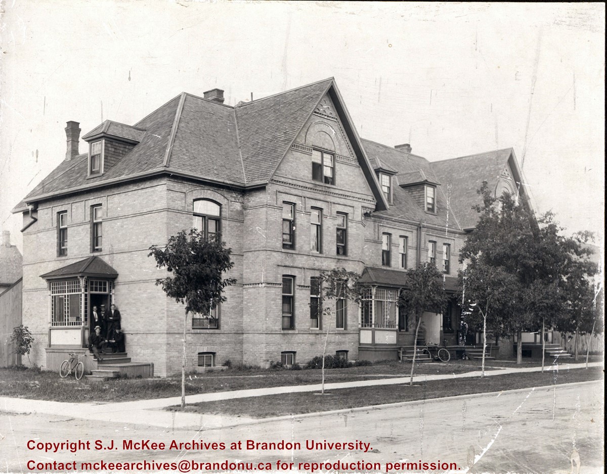
Photograph shows a three-storey multi-family brick house that appears to have at least four units. The structure also has a basement. A group of five men are posing on a stoop on the west side of the building. Sapplings have been planted on the boulevard in front the building.
Notes
Writing on the back of the photograph reads: Lorne Terrace, 12th and Lorne, always in the Hughes Family.
Name Access
12th Street
Lorne Avenue
Subject Access
residences
building exteriors
residential streets
street scenes
Storage Location
Hughes oversize drawer
Images
Show Less

20 records – page 1 of 1.