Site records have been scanned in multi-page PDF files.
History / Biographical
In 2005 the Brandon University Field School was held at both the Crepeele and Graham sites in the Crepeele locale.
Denise Ens instructed the school and James Graham was teaching assistant.
At the Crepeele site nine units were excavated (XU10-16 & 20, 21). Units 20 & 21 were referred to as Meadow in the notes but are considered part of the larger site based on recoveries
Scope and Content
Site records of excavation units may include: level summaries, floor plans, feature sheets, wall profiles, unit summaries and any other additional information relating to the unit.
Field journals have been scanned in multi-page PDF files. Artifact catalogues are PDF files in spreadsheet format. Photographs are in jpeg format.
History / Biographical
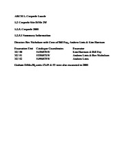
The Crepeele site was identified from the results of the Casselman survey and excavated in 2003, 2004, 2005 and 2007.
In 2005 and 2007 the Brandon University Archaeology Field School was held at the Crepeele site in the Crepeele locale.
In 2008 a small crew returned to the site to gather further samples and verify profiles. Three units (XU 50, 51 and 52) were excavated with faunal (animal bone), lithics, fire cracked rock, diagnostic lithics and ceramics recovered from the site. There are 455 records in the artifact catalogue.
Scope and Content
Sub-sub-sub series contains: Summary information of field methology, number and co-ordinates of excavations, personnel and their staff position.
Field journals have been scanned in multi-page PDF files.
History / Biographical
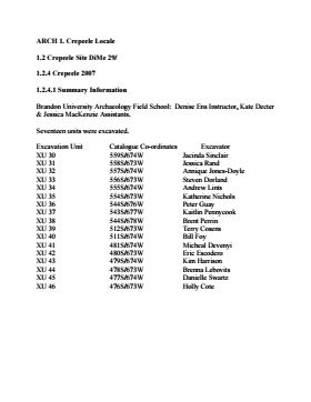
In 2007 the Brandon University Archaeology Field School was held at the Crepeele site in the Crepeele locale. Denise Ens instructed the school with Kate Decter & Jessica MacKenzie assistants.
Seventeen units were excavated XU30 - 46. Faunal (animal bone), lithics, fire cracked rock, diagnostic lithics and ceramics were recovered from the site. There are over 3050 records in the catalogue.
Scope and Content
Record of daily observations at the site including: excavation methods, items recovered, features, local environment and weather.
Field journals have been scanned in multi-page PDF files.
History / Biographical
The Crepeele site was identified from the results of the Casselman survey and excavated in 2003, 2004, 2005 and 2007.
In 2008 a small crew under the direction of Bev Nicholson returned to the site to gather further samples and verify profiles. Three units (XU 50, 51 and 52) were excavated. As well the Graham site 2008 was also excavated.
The field journals contain information about both the Crepeele and Graham sites.
Scope and Content
Record of daily observations at the site including: excavation methods, items recovered, features, local environment and weather.
Field journals have been scanned in multi-page PDF files. Artifact catalogues are PDF files in spreadsheet format. Photographs are in jpeg format.
History / Biographical
In 2007 the Brandon University Field School was held at both the Crepeele site in the Crepeele locale. Denise Ens instructed the school with Jessica McKenzie and Kate Decter as teaching assistants.
Seventeen units were excavated (XU3 - 46). Faunal (animal bone), lithics, fire cracked rock, diagnostic lithics and ceramics were recovered from the site.
Scope and Content
Sub-sub-sub series contains: Summary information of field methology, number and co-ordinates of excavations, personnel and their staff position.
Field journals have been scanned in multi-page PDF files.
History / Biographical
The Crepeele site was excavated in 2003 as Crepeele 3. Standard archaeological methods were used to excavate the units. Excavation units were initially numbered as units 10, 11, 12 & 13. These numbers have been changed on the catalogue to XU 110 – 113, due to duplication in 2005. Corresponding documents have been changed to reflect the amended excavation unit numbers, however the field journals may contain the initial numbers.
Scope and Content
Record of daily observations at the site including: excavation methods, items recovered, features, local environment and weather.
Field journals have been scanned in multi-page PDF files.
History / Biographical
The Crepeele site was identified from the results of the Casselman survey and excavated in 2003, 2004, 2005 and 2007.
In 2008 a small crew under the direction of Bev Nicholson returned to the site to gather further samples and verify profiles. Three units (XU 50, 51 and 52) were excavated. As well the Graham site 2008 was also excavated.
The field journals contain information about both the Crepeele and Graham sites 2008.
Scope and Content
Record of daily observations at the site including: excavation methods, items recovered, features, local environment and weather.
Field journals have been scanned in multi-page PDF files.
History / Biographical
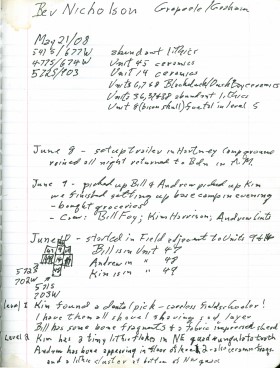
In 2008 Brandon University Archaeology returned to the Crepeele locale to conduct further testing at the Graham and Crepeele sites. Four units (XU 47-49 & 53) were excavated at Graham 2008 in order to collect samples and add further data to previous excavations. The usual excavation methology was employed.
The small crew was directed by Bev Nicholson with Crew of Bill Foy, Andrew Lints & Kim Harrison
Recoveries included faunal (mostly bison), lithics and ceramics.
The field journals contain information about both the Crepeele and Graham sites 2008.
Scope and Content
Record of daily observations at the site including: excavation methods, items recovered, features, local environment and weather.
Field journals have been scanned in multi-page PDF files.
History / Biographical
The Crepeele site was identified from the results of the Casselman survey and excavated in 2003, 2004, 2005 and 2007.
In 2008 a small crew under the direction of Bev Nicholson returned to the site to gather further samples and verify profiles. Three units (XU 50, 51 and 52) were excavated. As well the Graham site 2008 was also excavated.
The field journals contain information about both the Crepeele and Graham sites 2008.
Scope and Content
Record of daily observations at the site including: excavation methods, items recovered, features, local environment and weather.
Field journals have been scanned in multi-page PDF files. Artifact catalogues are PDF files in spreadsheet format. Photographs are in jpeg format.
History / Biographical
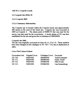
The Crepeele site was identified from the results of the Casselman survey. The site is located within the Crepeele locale approximately 400 meters to the west of the Sarah site. The units were excavated by Crew Chief James Graham and the crew from the survey.
The Crepeele site was excavated in 2003 as Crepeele 3 with the units numbered as units 10, 11, 12 & 13. These numbers have been changed on the catalogue to XU 110 – 113, due to duplication in 2005. Corresponding documents have been changed but there may be some reference to the initial numbers in the field journals.
The artifacts recovered from these four excavations are faunal (animal bone), mainly bison, lithic materials (stone tools and flakes) and some ceramic (pottery). The artifact catalogue has over 600 records.
Scope and Content
Sub-sub-sub series contains: Summary information of field methology, number and co-ordinates of excavations, personnel and their staff position; Field journalsare daily records of recoveries, features and activities at the site; Site records include excavation level and unit summaries, feature sheets, profiles; sample records and maps; Artifact catalogues are lists and identifications of all artifacts recovered; Photographs are of excavation units, features, the landscape and personnel.
The Lovstrom locale first came to the attention of Dr. Nicholson through conversations with landowners Mr. and Mrs. Herb Lovstrom in 1985. Lovstrom is a multi-component archaeological locale located 25km south of Brandon overlooking the Souris River channel. The landowner’s surface collection and the presence of bone and artifacts in a cultivated field indicated the presence of one or more sites.
Limited testing was conducted in 1985 and 1986, followed by major excavations in 1987, 1988 and 1991. Eight sites of block excavations with a total of 132 1m2 excavation units were completed. The locale area extends approximately 500m north from the edge of the Souris Valley escarpment and over 200m east from the Jock’s Creek escarpment.
Physical and biological environment As has been noted above, the locale is bounded on the south by the Souris channel and on the west by the incised channel of Jock’s Creek and a till plain extends to the north and the east. This plain is characterized by buff colored glacial till with numerous rocks embedded in the surface. Surrounding these rocky knolls are dark-soil hollows where the various cultural occupations are found. The depth of the topsoil layer suggests a long term grassland cover with the present oak forest likely developing in historic times due to the elimination of bison grazing and the controlling of prairie fires in late historic times. A small cleared patch of farmland is found within the boundaries of the locale area. This area has provided a substantial surface collection of artifacts.
Present vegetation in the area is a mosaic of aspen/oak forest groves and mesic grass prairie that includes introduced species such as brome grass. In poorly drained areas, willow and red osier dogwood are present. The Lovstrom locale is found in a forested area dominated by oak with an under story of saskatoon, chokecherry, pin cherry, and hazelnut brush. Poison ivy is abundant as well as sarsaparilla.
The major faunal resources in Precontact times would have been bison, with elk and mule deer playing a minor role. Antelope may have been present also. Small animals included snowshoe hare, cottontails, porcupines and beaver. Canids, including wolf, coyote, fox and domesticated dog were present, as well as mustelids such as badger, mink, and weasel. Fragments from a fisher were also recovered in the excavations.
Summation.
The Lovstrom locale has eight sites. The sites were designated and excavated as Blocks A, B, C, D, E, F, G and H. Many of the sites are multi-occupations.
The Vickers materials are primarily confined to Blocks D, E, F, G and H. Vickers Focus materials overlie Blackduck/Duck Bay materials. Blackduck and Duck Bay materials are found in the lower levels of all excavation blocks and in most test units. The Vickers occupations at the Lovstrom locale, based upon ceramic wares and an overlapping of C14 dates, appear to have been contemporary with the Lowton type site to the east, near Belmont. A small protohistoric occupation was identified overlying part of Block D. Faunal remains are abundant with bison clearly dominating the assemblages. Lesser amounts of canid are present as well as small mammals including beaver, hare and mustelids. Small amounts of avian species are also present.
Publications
Nicholson, B.A.
2011 The Role of Pocket Gophers (Thomomys talpoides) in Restructuring Stratigraphic Relationships at the Lovstrom Site. Canadian Journal of Archaeology 35:323-331.
Nicholson, Bev, Scott Hamilton, Matthew Boyd and Sylvia Nicholson
2008 A Late Plains Woodland Adaptive Strategy in the Northern Parklands: the Vickers Focus Forager-Horticulturists. Invited Paper for Papers in Northeastern Plains Prehistory, eds. Michael G. Michlovic and Dennis L. Toom, North Dakota Journal of Archaeology Vol. 8:19-34.
Nicholson, Bev and Scott Hamilton
2001 Cultural Continuity and Changing Subsistence Strategies During the Late Precontact Period in Southwestern Manitoba. Canadian Journal of Archaeology 25:53-73.
Nicholson, Bev
1996 Plains Woodland Influx and the Blackduck Exodus in South-Western Manitoba During the Late Precontact Period. Manitoba Archaeological Journal 6(1):69-85.
Nicholson, Bev and Mary Malainey
1991 Report on the 1991 Field School Excavations at the Lovstrom Site (DjLx-1), Southwestern Manitoba. Manitoba Archaeological Journal 1(2): 51-93.
Nicholson, Bev and Jane Gibson
1990-91 Lovstrom Site Field Report, 1987 Excavations. Saskatchewan Archaeology 11&12:46-68.
Nicholson, Bev and Ian Kuiijt
1990 Field Report and Interpretations of the 1988 Archaeological Excavations at the Lovstrom Site (DjLx-1) in Southwestern Manitoba. North Dakota Journal of Archaeology 4:166-205.
Nicholson, Bev
1990 Ceramic Affiliations and the Case for Incipient Horticulture in Southwestern Manitoba. Canadian Journal of Archaeology 14:33-60.
Nicholson, Bev
1986 The Lovstrom Site: Culture Contact in Prehistory. Manitoba Archaeological Quarterly 10(1):35-71.
Scope and Content
The Series has been divided into nine sub-series, including (1) Survey (2) Block A; (3) Block B (4) Block C; (5) Block D; (6) Block E; (7) Block F; (8) Block G; (9) Block H
Introduction
Information on archaeological materials in this locale first came to the attention of Dr. Nicholson through Doug Jackson, a local artifact collector from Souris. Doug had observed archaeological materials that included bone, ceramics and lithic material that had been exposed by municipal road building activity, northwest of Lauder Manitoba
Environment
The Makotchi-Ded Dontipi locale is located among stabilized sand dunes in the Lauder Sandhills in Southwestern Manitoba, northwest of the village of Lauder. The area is a mosaic of medium grass prairie and copses of aspen poplar and aspen-oak, together with intermittent sedge grass marshes and small ponds. These wetlands are bordered with balsam poplar, water birch, willows and red osier dogwood.
The well-drained upland forest also contains saskatoon, chokecherry, wild current, hazelnut bushes and occasional wild plums. Lowland areas have nannyberries and high-bush cranberry. Wild strawberries grow in lightly shaded areas along trail margins and in open patches in aspen forest.
History of Excavations
The Makotchi-Ded Dontipi locale is a virtual "island" of forest and marshlands in a vast expanse of mixed grass prairie. This archaeologically and environmentally rich area was given the Dakota name Makotchi-Ded Dontipi, meaning "the place where we live".
Summation
Prior to European settlement, the area was a rich environment for hunter-gatherer people. Archaeological investigations from 1992 to 2002 have revealed numerous sites within the locale. Some of these sites have been extensively excavated while others have been identified or tested.
Seven sites that have been identified in this locale range in age from the historic through protohistoric periods and extend into the middle precontact period. The major sites are the initial Middle Missouri Duthie site, the late precontact Jackson, Bradshaw sites and the protohistoric Twin Fawns, Schuddemat and Hollow B sites. The multi-component Vera site includes historic Métis, late precontact Vickers Focus, and middle precontact Besant, Pelican Lake, McKean Complex and Oxbow occupations. Over 230 units were excavated as well as numerous test pits and several extensive surveys.
Scope and Content
Scope and Content
The Series has been divided into seven sub-series, including (1) Duthie site (2) Jackson site (3) Twin Fawns site (4) Vera site (5) Schuddemat site (6) Bradshaw site (7) Hollow B site.
ARCH 2: North Lauder Locale
The North Lauder locale has a long archaeological and geological history that is important for understanding the forces that shaped the region. Archaeological research in the locale shows that the area has been occupied by humans for at least the past 6,500 years. Environmental forces provided an area of diverse resources that attracted early peoples.
Environment of the Lauder Sandhills
The North Lauder locale is part of the greater Lauder Sandhills area. The glaciers that covered this region began to recede approximately 11,000 years ago leaving a large lake known as glacial Lake Hind. The Souris River, the Lauder Sandhills and the Oak Lake Aquifer are remnants of the environmental and geological forces that shaped the region.
The Lauder Sandhills region is characterized by a landscape of sand sheets and stabilized sand dunes interspersed with a variety of wetlands. This complex topographic and hydrological situation favoured the development of an island mosaic of mixed forest, wetland and meadow, surrounded by mixed grass prairie. The result was a large, isolated ecotone which provided a rich variety of subsistence resources for hunter-gatherers.
Research in the Lauder Sandhills
Archaeologists from Brandon University have been conducting research in the Lauder Sandhills since 1991. Research in the North Lauder locale has focused on the Atkinson site, a 6,500 year old hunter-gatherer site and Flintstone Hill.
The Atkinson site
The Atkinson site is one of the oldest excavated sites in Manitoba and has been Radiocarbon dated to 6,500 years before present. The Atkinson site is located on the bank of the Souris River and was discovered when a hearth (fire pit) was seen eroding out of the bank. Based on the date of the site and the kind of lithics (stone tools) present it is considered a Gowen occupation. The Atkinson site is evidence that bison hunters were active on the northern plains at a very early date. Similar sites have also been found on the High Plains in the U.S. and are referred to as the Mummy Cave Complex.
The Atkinson Site is of great importance as it is the first undisturbed site of this type to be excavated in Manitoba and extends the range of these sites south and east from the type-sites in central Saskatchewan.
Flintstone Hill
The geomorphology of the glacial Lake Hind Basin over the past 11,000 years is known primarily through the study of a cut bank along the Souris River. Flint Stone Hill contains the most complete stratigraphic record for the post-glacial period on the northern plains. The site has been extensively studied by geoarchaeologists, geologists and paleoenvironmentalists over many years and their findings have contributed to our understanding of the region.
The North Lauder locale Borden designations of Atkinson site DiMe-27 and Flintstone Hill site DiMe-26.
Borden System
Archaeological sites in Canada are identified by the Borden system, which is a uniform site designation system. The country is divided into grids based on latitude and longitude in blocks of 10 x 20 minutes. The first 4 letters indicate the block and the following numbers indicate the actual site. For example the area of the Lauder Sandhills in southwestern Manitoba is identified by the letters DM and the North Lauder locale within that area is DiMe. The Atkinson site is DiMe-27 and the Flintstone Hill site DiMe-26. As new sites are discovered they will be numbered sequentially.
Scope and Content
The Series has been divided into two sub-series, including (1) Atkinson site DiMe-27 and Flintstone Hill site DiMe-26.
The high biodiversity and evidence of pre-Europeon contact prompted the decision to test the Crepeele locale. The survey was named in recognition of the Casselman family, the original landowners.
Archaeological testing began in the Crepeele locale in May 2003 on property now owned by the Crepeele family. The locale covers over 6 sections or approximately 3,800 acres of land in an area of stabilized sand dunes and wetlands covered with mixed forest and prairie grass. Given the terrain, the size of the crew and time constrains, an area of approximately 60 acres was chosen for the survey. The survey used the established archaeological methodology of walking the selected area and using a shovel test surveyed grid. The use of GIS technology to locate the exact test spot and record the information into a GIS database was a significant advance and was one of the advantages of the integration of multi-disciplinary techniques encouraged by the SCAPE project. Over one half of the test pits resulted in the recovery of cultural materials. The results of the Casselman survey indicated several areas for further examination including areas that became the Crepeele, Sarah and Graham sites.
Scope and Content
Sub sub series has been divided into five sub sub sub series including: (1) Summary information; (2) Field journals; (3) Site records; (4) Artifact catalogues; and (5) Photographs.
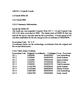
The Sarah site was chosen for excavation based on the results of the Casselman survey. The survey recovered significant amounts of faunal remains, some ceramics and lithics from the test pits. Excavations took place in 2003 at Crepeele West (Units 1-5) and Crepeele East (Units 6-9). The site was subsequently renamed the Sarah site DiMe-28. In 2004 another 9 units were excavated (Units 10-18).
Based on the recoveries it was determined that the Sarah site is a stratified site with woodland ceramics in the upper occupation and late woodland points in both of the upper occupations. These upper occupations produced abundant bison bone including foetal bone. The lower occupations produced less bone and no foetal bone, although absence of foetal bone in the lower occupations does not necessarily indicate a warm season occupation. This could be due to sample error or perthotaxic factors such as scavenging of the fragile bone by dogs or other carnivores.
The dates from the Sarah site include 550+/-40 B.P.; 1430+/-80 B.P; 2810+/-80 B.P.; 3120+/-130 B.P. The lower occupations did not yield any diagnostic materials although debitage was abundant. These occupations were most productive at the edge of the large sand dune at the southern edge of the excavations. It is assumed that the major portion of these occupations have been overridden by the dune in the past 3000 years. Heavy earthmoving equipment would be required to remove this overburden which limits the possibility of future excavation.
Environment
The Sarah site is a large area located at the eastern end of the Crepeele locale. Ground cover is a mosaic of aspen poplar groves and patches of mesic grass prairie. Excavation profiles indicate that this has been the situation since early precontact times, although as local climatic conditions change (primarily rainfall), the relative size of these areas and where they may have occurred also changed. The soil is aeolian sand sheet derived from delta outwash deposits along the western edge of glacial Lake Hind. The present topography is a variable dune landscape reworked by aeolian activity that creates a mosaic of microhabitats. These include forested patches in the lee of sand dunes with grassland on the southern and western exposures and small damp lowlands that support balsam poplar, willows, red osier dogwood, high-bush cranberry and water birch. There is no permanent water source in the area although a small seasonal stream meanders through a damp lowland to the east of the Sarah site.
Scope and Content
Sub-series has been divided into sub sub series including: Sarah 2003 and Sarah 2004,
The Graham site is a located adjacent to the Crepeele site towards the western end of the Crepeele locale. The Graham site was initially designated as a separate site early in the testing of the Crepeele locale due to what appeared to be a distinction between Early and Late Woodland ceramics. Subsequent testing has shown that this distinction was premature and that the cultural mosaic represented in the western section of the Crepeele locale may not readily separate in this manner. However, due to the records management that was already in place, the original separate designations have been retained.
Environment
Ground cover is a mosaic of aspen poplar groves and patches of mesic grass prairie. Excavation profiles indicate that this has been the situation since early precontact times, although as local climatic conditions change (primarily rainfall), the relative size of these areas and where they may have occurred also changed. The soil is aeolian sand sheet derived from delta outwash deposits along the western edge of glacial Lake Hind. The present topography is a variable dune landscape reworked by aeolian activity that creates a mosaic of microhabitats. These include forested patches in the lee of sand dunes grassland on the southern and western exposures and small damp lowlands that support balsam poplar, willows, red osier dogwood, high-bush cranberry and water birch. There is no permanent water source in the area although a small seasonal stream meanders through a damp lowland along the eastern margin of the Crepeele locale.
Excavations at the Graham site took place from 2004 to 2008. Analyses of the recoveries shows that, with two exceptions, all of the occupations that have been tested produced bison foetal bone. The presence of foetal bison is a strong indicator of wintering occupations...The absence of foetal in some area does not necessarily indicate warm season occupations since these excavation series are small and the absence could be due to sample error or perthotaxic factors, such as scavenging of the fragile bone by dogs or other carnivores.
From this evidence the Graham site has been interpreted as being primarily a wintering area. This is consistent with the lack of surface water (snow would serve as a substitute in winter) and the abundance of wood for fuel – a critical requirement for winter occupation. Cultural occupations date from Mortlach circa 250 B.P to woodland circa 580 B.P.
Scope and Content
Sub-series has been divided into sub sub series including: Graham 2004, Graham 2005, Graham 2006 and Graham 2008
Field journals have been scanned in multi-page PDF files. Artifact catalogues are PDF files in spreadsheet format. Photographs are in jpeg format.
History / Biographical
Archaeological testing began in the Crepeele locale in May 2003 with a field crew of four members. James Graham supervised the crew and was assisted by Sarah Graham, Jollana Bishop, and Lisa Sonnenburg. Later additions to the testing team were Todd Kristensen, Michael Evans, and Emily Ansell.
The methodology for this survey used an arbitrary datum and a transit to establish a grid of 30 m intervals and a shovel test every 20 m. Materials were removed and screened to a minimum depth of 50 cm below surface. All recovered materials were bagged and removed to the lab for further analysis. All information including: test pit grid co-ordinates; UTM co-ordinates for each test pit; artifact presence; excavator; vegetation; aspect; paleosol; paleosol depth; and notes, were entered into a GIS database.
Approximately 600 shovel test pits were excavated and recorded in this fashion. Of the 600 shovel test pits, over 300 contained cultural materials. Based on the results of the Casselman survey several areas were designed for further testing and excavation. Crepeele West and Crepeele East were renamed the Sarah site DiMe-28) and Crepeele 3 which became the Crepeele site DiMe- 29.
Scope and Content
Sub-sub-sub series contains: Summary information of field methology, number and co-ordinates of excavations, personnel and their staff position; Field journalsare daily records of recoveries, features and activities at the site; Site records include excavation level and unit summaries, feature sheets, profiles; sample records and maps; Artifact catalogues are lists and identifications of all artifacts recovered; Photographs are of excavation units, features, the landscape and personnel.
Field journals have been scanned in multi-page PDF files. Artifact catalogues are PDF files in spreadsheet format. Photographs are in jpeg format.
History / Biographical
The Sarah site was initially chosen for excavation based on the results of the Casselman survey. The survey recovered significant amounts of faunal remains, some ceramics and lithics from the test pits. Excavations took place in 2003 at Crepeele West (Units 1-5) and Crepeele East (Units 6-9). The site was subsequently renamed the Sarah site DiMe-28.
Units 1 to 9 were excavated by supervisor James Graham and crew of Sarah Graham, Mike Evans, Todd Kristensen, Shayne Kolesar, Lisa Sonnenburg and Emily Ansell.
Scope and Content
Sub-sub-sub series contains: Summary information of field methology, number and co-ordinates of excavations, personnel and their staff position.
Field journals have been scanned in multi-page PDF files. Artifact catalogues are PDF files in spreadsheet format. Photographs are in jpeg format.
History / Biographical
The Graham site is located south of the Crepeele site. Due to the close proximity the Graham and Crepeele sites have both been the site of the Brandon University Archaeological Field School.
In 2006 a small Brandon University Archaeology Field School was conducted at the Graham site. Four excavations (XU 7, 8 15 & 16) were completed with Denise Ens Instructor and Jessica MacKenzie Teaching Assistant.
Recoveries included faunal (mostly bison), lithics and ceramics
The Graham site was initially designated as a separate site early in the testing of the Crepeele locale due to what appeared to be a distinction between Early and Late Woodland ceramics. Subsequent testing has shown that this distinction was premature and that the cultural mosaic represented in the western section of the Crepeele locale does not readily separate in this manner.
Scope and Content
Sub-sub-sub series contains: Summary information of field methology, number and co-ordinates of excavations, personnel and their staff position; Field journalsare daily records of recoveries, features and activities at the site; Site records include excavation level and unit summaries, feature sheets, profiles; sample records and maps; Artifact catalogues are lists and identifications of all artifacts recovered; Photographs are of excavation units, features, the landscape and personnel.