Skip header and navigation

Revise Search

13 records – page 1 of 1.

Album - Trembley iron ore cars

http://archives.brandonu.ca/en/permalink/descriptions14221
Part Of
Fred McGuinness collection
Description Level
Item
GMD
graphic
Date Range
[1900s]
Accession Number
1-2015
Part Of
Fred McGuinness collection
Description Level
Item
Series Number
McG 9
Item Number
1-2015.277.A13
Accession Number
1-2015
GMD
graphic
Date Range
[1900s]
Physical Description
4" x 2.5" (b/w)
Material Details
mounted in album
Physical Condition
Photo is warped
History / Biographical
Trembley was a point along the Algoma Central Railway line that connected the Helen Mine to the Michipicoten Harbour. It is located southwest of Wawa, Ontario.
Scope and Content
Photograph shows railroad tracks. A line of ore cars stretch along one track. Writing on the side of one of the cars (#3017) reads: Algoma Central Railway Co.
Notes
Writing beneath the photograph in the album reads: Trembley - Ore Cars
Name Access
Algoma Central Railway Co.
Subject Access
Railroad Transportation
railways
mines
Storage Location
1-2015 McG 1.4 Box 1 (in stacks, top shelf)
Images
Show Less

Billy Muir's car c.1910

http://archives.brandonu.ca/en/permalink/descriptions13754
Part Of
Fred McGuinness collection
Description Level
Item
GMD
graphic
Date Range
c.1910
Accession Number
20-2009
Part Of
Fred McGuinness collection
Description Level
Item
Series Number
McG 9
Item Number
20-2009.65
Accession Number
20-2009
GMD
graphic
Date Range
c.1910
Physical Description
5.5" x 3.5" (b/w)
Material Details
postcard
History / Biographical
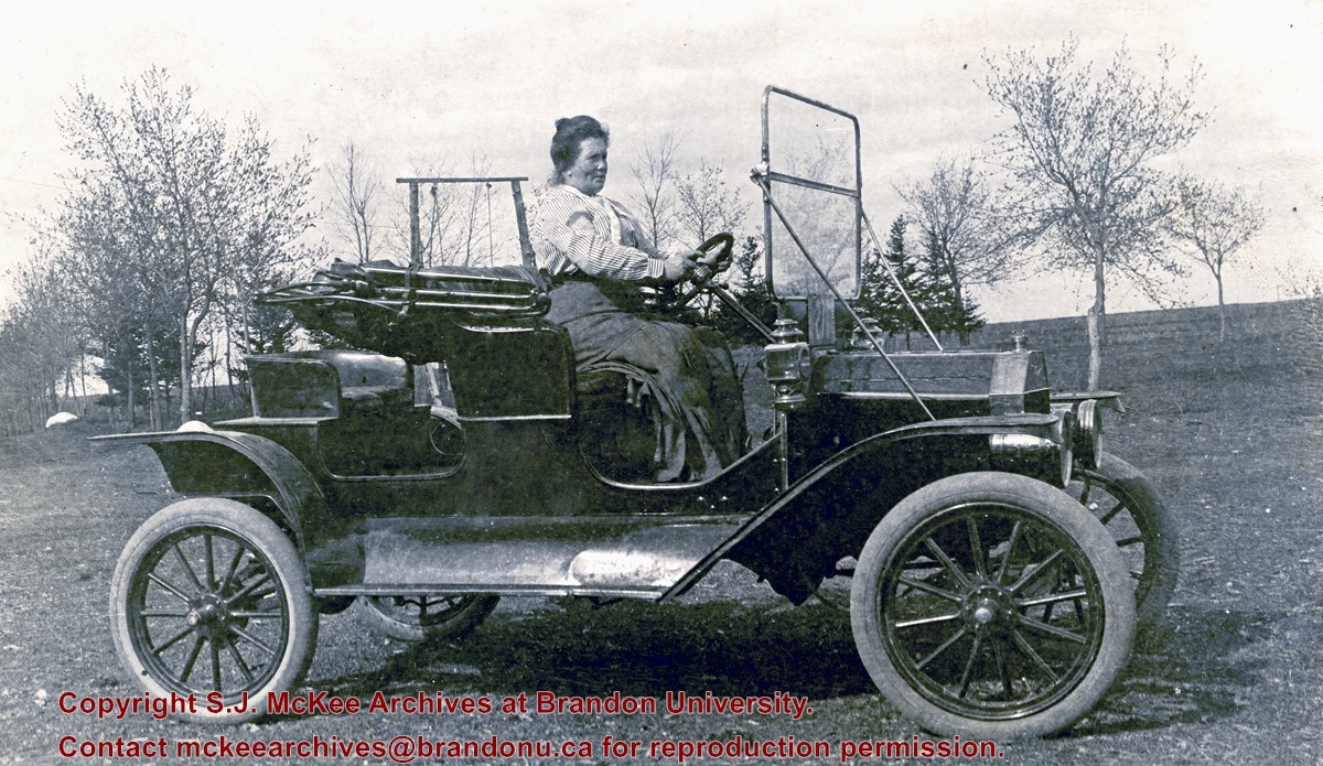
William "Billy" Muir came to Brandon in 1881 where he worked at the Coombs & Stewart general store. He became the proprietor of Brandon's first grocery store located on 138-6th Street. The building was demolished in 1952 (see Brandon Daily Sun 04 September 1952). According to correspondence in the McGuinness collection (see McG 1.2 File 22), Dr. Matheson brought the first car to Brandon, which he later sold to Muir. A note in McGuinness' papers (see McG 1.2 File 53) identifies the first motor car as a Hupmobile, which was purported to have arrived in Brandon in 1905. The Hupp Motor Car Company, however, is reported to have manufactured Hupmobiles between 1909 and 1940. Mrs. (Jessie) R.M. Coombs was Allena Strath's (nee Coombs) mother.
Custodial History
Donated to Fred McGuinness by Allena Strath (nee Coombs).
Scope and Content
Postcard shows a woman, identified as Mrs. (Jessie) Robert M. Coombs, seated behind the wheel of a motor car.
Notes
Back of postcard reads: Mother Mrs. R. [Robert] M. Coombs in Billy Muir's car, Brandon around 1908
Name Access
Billy Muir
William Muir
Mrs. Robert M. Coombs
Jessie Coombs
Wm. Muir General Grocer
Subject Access
Transportation
cars
automobiles
motor cars
Storage Location
RG 5 photograph storage drawer 2 (hanging photos)
Images
Show Less

Brandon Municipal Railway car in winter

http://archives.brandonu.ca/en/permalink/descriptions13869
Part Of
Fred McGuinness collection
Description Level
Item
GMD
graphic
Date Range
[19--]
Accession Number
20-2009
Part Of
Fred McGuinness collection
Description Level
Item
Series Number
McG 9
Item Number
20-2009.179
Accession Number
20-2009
GMD
graphic
Date Range
[19--]
Physical Description
3.75" x 2.5" (b/w)
Material Details
reproduction
Custodial History
Image submitted to Fred McGuinness by T. Horobin of Brandon
Scope and Content
Photograph shows a man, perhaps an engineer standing next to a Brandon Municipal Railway car covered in snow. A Brandon Municipal Railway token/tag is affixed to the image.
Name Access
Brandon Municipal Railway
Subject Access
streetcars
street cars
Transportation
winter
Storage Location
RG 5 photograph storage drawer 2 (hanging photos)
Arrangement
From 20-2009 File 9
Images
Show Less

Brandon Building Movers (4)

http://archives.brandonu.ca/en/permalink/descriptions14265
Part Of
Fred McGuinness collection
Description Level
Item
GMD
graphic
Date Range
[1980s]
Accession Number
1-2015
Part Of
Fred McGuinness collection
Description Level
Item
Series Number
McG 9
Item Number
1-2015.285
Accession Number
1-2015
GMD
graphic
Date Range
[1980s]
Physical Description
1.5 " x 1.5" (colour)
Material Details
negative
Scope and Content
Photograph shows a house being hauled by Brandon Building Movers truck as it attempts to turn onto a country road.
Name Access
Brandon Building Movers
Subject Access
Transportation Manitoba
Storage Location
RG 5 photograph storage drawer 2 (hanging photos)
Arrangement
Cigar boxes
Images
Show Less

Mulgrave, N.S. train station postcard

http://archives.brandonu.ca/en/permalink/descriptions13938
Part Of
Fred McGuinness collection
Description Level
Item
GMD
graphic
Date Range
1940s
Accession Number
1-2015
Part Of
Fred McGuinness collection
Creator
Photograph by: Fad Foto
Description Level
Item
Series Number
McG 9
Item Number
1-2015.10
Accession Number
1-2015
GMD
graphic
Date Range
1940s
Physical Description
5.5" x 3.5" (b/w)
Material Details
postcard
Scope and Content
Photograph shows the train station at the port of Mulgrave, Nova Scotia. Possibly the site where the HMCS Alachasse was docked when Fred McGuinness was a telegraphers in the Canadian Navy.
Notes
Writing on the back of the postcard reads: AZO post card
Name Access
Mulgrave, Nova Scotia
Subject Access
train stations
railways
Storage Location
RG 5 photograph storage drawer 2 (hanging photos)
Arrangement
Loose photos in funny trunk
Images
Show Less

Building fire near rail yard

http://archives.brandonu.ca/en/permalink/descriptions14127
Part Of
Fred McGuinness collection
Description Level
Item
GMD
graphic
Date Range
[1960-1965]
Accession Number
1-2015
Part Of
Fred McGuinness collection
Description Level
Item
Series Number
McG 9
Item Number
1-2015.196
Accession Number
1-2015
GMD
graphic
Date Range
[1960-1965]
Physical Description
3" x 3" (b/w)
Scope and Content
Photograph shows a dark cloud of smoke emerging from a building or warehouse near a train yard.
Subject Access
fires
trains
railways
Storage Location
RG 5 photograph storage drawer 2 (hanging photos)
Arrangement
BR #3 Family photos
Images
Show Less

Building fire near rail yard

http://archives.brandonu.ca/en/permalink/descriptions14128
Part Of
Fred McGuinness collection
Description Level
Item
GMD
graphic
Date Range
[1960-1965]
Accession Number
1-2015
Part Of
Fred McGuinness collection
Description Level
Item
Series Number
McG 9
Item Number
1-2015.197
Accession Number
1-2015
GMD
graphic
Date Range
[1960-1965]
Physical Description
3" x 3" (b/w)
Scope and Content
Photograph shows a dark cloud of smoke emerging from a building or warehouse near a train yard.
Subject Access
fires
trains
railways
Storage Location
RG 5 photograph storage drawer 2 (hanging photos)
Arrangement
BR #3 Family photos
Images
Show Less

Album - yard at Brient

http://archives.brandonu.ca/en/permalink/descriptions14216
Part Of
Fred McGuinness collection
Description Level
Item
GMD
graphic
Date Range
[1900s]
Accession Number
1-2015
Part Of
Fred McGuinness collection
Description Level
Item
Series Number
McG 9
Item Number
1-2015.277.A8
Accession Number
1-2015
GMD
graphic
Date Range
[1900s]
Physical Description
4" x 2.5" (b/w)
Material Details
mounted in album
Physical Condition
Photo is warped
History / Biographical
Brient was a point along the Algoma Central Railway line that connected the Helen Mine to the Michipicoten Harbour. It is located southwest of Wawa, Ontario.
Scope and Content
Photograph shows ore box cars in a railway yard.
Notes
Writing beneath the photograph in the album reads: yard at Brient
Name Access
Brient, Ontario
Subject Access
mines
railways
Transportation
winter
Storage Location
1-2015 McG 1.4 Box 1 (in stacks, top shelf)
Images
Show Less

Medicine Hat Exhibition and Stampede - Parade Day 4

http://archives.brandonu.ca/en/permalink/descriptions14145
Part Of
Fred McGuinness collection
Description Level
Item
GMD
graphic
Date Range
1962
Accession Number
1-2015
Part Of
Fred McGuinness collection
Creator
Photographer: Howard Heid, Medicine Hat News
Description Level
Item
Series Number
McG 9
Item Number
1-2015.214
Accession Number
1-2015
GMD
graphic
Date Range
1962
Physical Description
10" x 8" (b/w)
History / Biographical
The Medicine Hat Exhibition and Stampede Parade Day was held on Thursday, July 19, 1962, at 9:30 a.m. The local newspaper reported that approximately 24,000 people were in attendance to see parade marshall Rod Ashburner leading 175 entries consisting of 90 floats, 75 horses, and 10 bands. There were 19 parade categories eligible for $12,000 in prize money and included: junior and senior cowboys and cowgirls; fancy and Shetland ponies; sulky class open; comic, commercial, industrial and organizational floats; decorated cars; special ranch class; 4-H Clubs; and a non-competitive class. The parade route started at Second St. and Allowance Ave., from Second St. to Ash Ave., north on Ash to First St. SE., from First St. S.E. to Fourth Ave., south to Second St. to South Railway St., south on South Railway St. to Third St., with a finish at McLeod Trail. A route map was published in the Medicine Hat News the day before the parade. Aerial photographs of the parade were taken by Medicine Hat News photographer Howard Heid (1930-2005) from the private helicopter of John Bourn. Bourn was a pilot from Woodville, Wisconsin, who chartered his four-seater helicopter for sight-seers at exhibitions and stampedes across the county. (Sources: Pat Currie, "Let 'Er Go!," Medicine Hat News, 19 July 1962,1; Harald Gunderson, "'Eye in the Sky' Best Parade View," Medicine Hat News, 19 July 1962,1; "Parade Starts at 9:30 Sharp," 18 July 1962)
Scope and Content
Photograph shows an aerial view of the Medicine Hat Exhibition and Stampede Parade route with a focus on the First Street SE. A number of gas stations and garages are visible along this route and include Texaco, Shell, Ford, and B/A. The Fraternal Order of Eagles lodge is also visible.
Notes
This photograph appeared on the front page of The Medicine Hat News (19 July 1962).
Name Access
Medicine Hat
South Saskatchewan River
Subject Access
parades
floats
aerial photography
aerial views
street scenes
fraternal organizations
garages
Repro Restriction
Subject to Canadian Copyright Law
Storage Location
RG 5 photograph storage drawer 2 (hanging photos)
Arrangement
BR #3 Family photos
Images
Show Less

Album - station at Brient

http://archives.brandonu.ca/en/permalink/descriptions14217
Part Of
Fred McGuinness collection
Description Level
Item
GMD
graphic
Date Range
[1900s]
Accession Number
1-2015
Part Of
Fred McGuinness collection
Description Level
Item
Series Number
McG 9
Item Number
1-2015.277.A9
Accession Number
1-2015
GMD
graphic
Date Range
[1900s]
Physical Description
4" x 2.5" (b/w)
Material Details
mounted in album
Physical Condition
Photo is warped
History / Biographical
Brient was a point along the Algoma Central Railway line that connected the Helen Mine to the Michipicoten Harbour. It is located southwest of Wawa, Ontario.
Scope and Content
Photograph shows several men standing on railway tracks before a wood-framed train station in the winter. A sign attached to the station reads: British American Express Co. The man in the foreground appears to have a mailbag over on his back and several newspapers tucked beneath his arm.
Notes
Writing beneath the photograph in the album reads: station at Brient
Name Access
Brient, Ontario
Subject Access
railways
train stations
Transportation
winter
Storage Location
1-2015 McG 1.4 Box 1 (in stacks, top shelf)
Images
Show Less

Album - Algoma Central and Hudson Bay Line

http://archives.brandonu.ca/en/permalink/descriptions14222
Part Of
Fred McGuinness collection
Description Level
Item
GMD
graphic
Date Range
[1900s]
Accession Number
1-2015
Part Of
Fred McGuinness collection
Description Level
Item
Series Number
McG 9
Item Number
1-2015.277.A14
Accession Number
1-2015
GMD
graphic
Date Range
[1900s]
Physical Description
4" x 2.5" (b/w)
Material Details
mounted in album
Physical Condition
Photo is warped
History / Biographical
In 1901, American entrepreneur Francis Hector Clergue (1856-1939) obtained the charter for the Ontario, Hudson Bay and Western Railway. Following his purchase, he reincoporated the Algoma Central Railway to the Algoma Central and Hudson's Bay Railway. (Source: Sault St. Mairie Public Library, "Transportation - Algoma Central Railway," Sault History Online, 2008)
Scope and Content
Photograph shows railroad tracks cutting through the Canadian Shield.
Notes
Writing beneath the photograph in the album reads: Algoma Central & Hundson Bay Ry.
Name Access
Algoma Central Railway Co.
Subject Access
Railroad Transportation
railways
mines
railroads
Storage Location
1-2015 McG 1.4 Box 1 (in stacks, top shelf)
Images
Show Less

Album - Lake Talbot Trestle

http://archives.brandonu.ca/en/permalink/descriptions14223
Part Of
Fred McGuinness collection
Description Level
Item
GMD
graphic
Date Range
[1900s]
Accession Number
1-2015
Part Of
Fred McGuinness collection
Description Level
Item
Series Number
McG 9
Item Number
1-2015.277.A15
Accession Number
1-2015
GMD
graphic
Date Range
[1900s]
Physical Description
4" x 2.5" (b/w)
Material Details
mounted in album
Physical Condition
Photo is warped
History / Biographical
The Lake Talbot tresle was a point along the Algoma Central Railway line that connected the Helen Mine to the Michipicoten Harbour. It is located north of Wawa and southwest of the Helen Mine.
Scope and Content
Photograph shows several men walking a railway line. Before them is a tresle bridge.
Notes
Writing beneath the photograph in the album reads: Lake Talbott Tresle [sic.]
Subject Access
Railroad Transportation
railways
mines
railroads
Storage Location
1-2015 McG 1.4 Box 1 (in stacks, top shelf)
Images
Show Less

Brandon street cars in front of Winter Fair Building on 10th Street

http://archives.brandonu.ca/en/permalink/descriptions13753
Part Of
Fred McGuinness collection
Description Level
Item
GMD
graphic
Date Range
1913
Accession Number
20-2009
Part Of
Fred McGuinness collection
Description Level
Item
Series Number
McG 9
Item Number
20-2009.64
Accession Number
20-2009
GMD
graphic
Date Range
1913
Physical Description
5.5" x 3.5" (b/w)
Material Details
postcard
Physical Condition
Postcard is discoloured around the edges
History / Biographical
According to the Brandon Daily Sun (07 May 1913), the first three street cars (Nos. 10, 9, and 7) arrived in Brandon on the evening of May 6, 1913. The cars were shipped via Canadian National Rail to Brandon from Winnipeg and stored at the railway siding on McTavish Avenue between 8th and 9th Streets. The daily paper (15 May 1915) reported that a test run for the street cars was scheduled for May 16, 1913. The City Clerk published a public notice in the paper (29 May 1913) announcing the formal opening of the "Brandon Municipal Street Raily" for on Monday, June 2, from 2 p.m. to 4 p.m. at city hall where the cars would be displayed.
Custodial History
Donated to Fred McGuinness by Allena Strath (nee Coombs).
Scope and Content
Postcard depicts three municipal street cars parked on the 10th Street tracks in front of the Winter Fair Building. In front of the cars are a group of men wearing suits, hats, and top coats. Two automobiles are parked alongside the street cars. According to Archivist Emeritus Tom Mitchell, the group of men are members of the Brandon Municipal Street Railway Committee. The chairman of the committee, Harry Cater, can be seen in the center-left of the group wearing a watch fob. The committee had assembled for a test run of the street car service, which the Brandon Daily Sun reported to have occured on Sunday, May 16, 1913.
Notes
Back of postcard reads: First Street Car in Brandon in front of Winter Fair building 1910.
Name Access
Brandon Municipal Railway
Winter Fair Building
Harry Cater
10th Street
Subject Access
street cars
Transportation
cars
automobiles
Storage Location
RG 5 photograph storage drawer 2 (hanging photos)
Related Material
Lawrence Stuckey collection 1-2002.3.1I2
Images
Show Less

13 records – page 1 of 1.