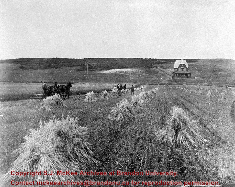
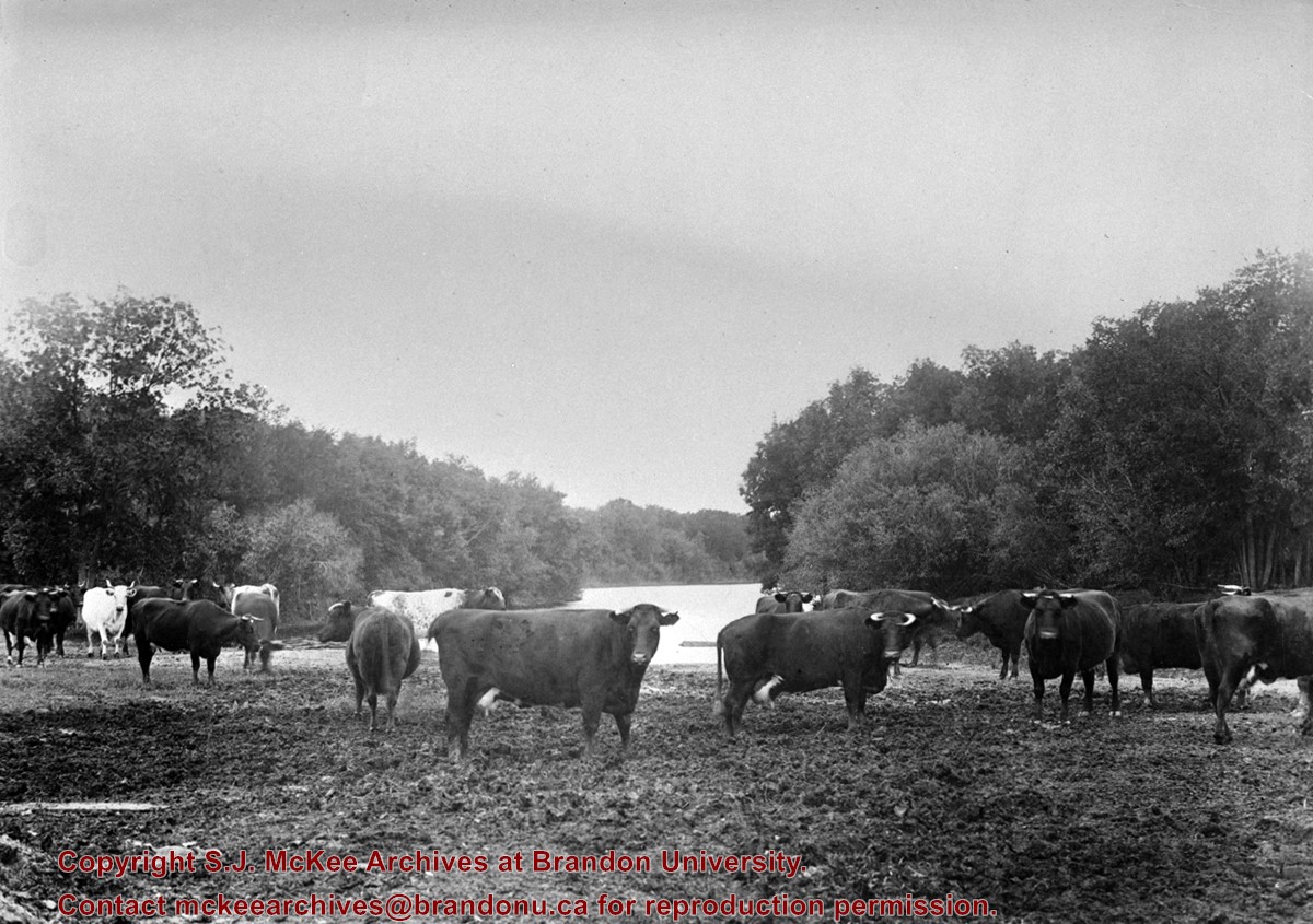
Bylaws to keep cattle off streets were being debated by city council about this time.
Custodial History
For custodial history see the collection level description of the Lawrence Stuckey collection.
Scope and Content
J. Birtles Meat Market "Family Butcher", 608 Rosser Avenue
Notes
Mr. Birtles on right, including Mr. Hammell, Hiram Chesley, and Lew Wicket; Photo includes Red Cross Drug Store with proprietor Mr. McCullagh in front; From Brandon Sun files.
The Brandon Club (L. of center) was built in 1904. This local businessmen's club met in the old firehall until this building was erected by them.
[The Brandon Club closed and its assets were sold at auction on 18 June 2005. P.E. 01/06/2009]
Custodial History
For custodial history see the collection level description of the Lawrence Stuckey collection.
Scope and Content
Overhead view of Princess Avenue, west of 10th Street
Notes
Taken from roof of Prince Edward Hotel. Shows: Rat Portage Lumber Co., St. Matthew's Hall, Brandon Club, In distance Brandon College, International Harvester, Pumping Station. End of brick pavement at 14th Street is notable.
[The land on which city hall stood in this photo is now known as Princess Park. P.E. 01/06/09]
Custodial History
For custodial history see the collection level description of the Lawrence Stuckey collection.
Scope and Content
Princess Avenue, showing City Hall & CKX radio tower
Notes
[View is from 9th Street looking east. P.E.]
"Radio towers of CKX on city hall grounds were 150 feet tall; Studio and transmitter were on the east side of city hall." - Fred McGuinness collection (20-2009).
July 12 Orange Lodge parade in progress; Shows that there was a building in what was for many years, a small vacant lot behind the Bank of Montreal; Campbell & Campbell building and Security Block. Davidson (photography) Studio on awning - became Henfries studio and, in 1923, Jerrets' Studio.
Custodial History
For custodial history see the collection level description of the Lawrence Stuckey collection.
Scope and Content
100 Block of Tenth Street
Notes
Probably taken from Strathcona Block
Creator provided by Fred McGuinness collection (20-2009).
After demise of the streetcars, a transit system was started by MacArthur Transportation Co. with three routes, an east end loop, a south end loop, and a west end loop, with terminal at 8th St. & Rosser Ave. The E & W was operated as a continuous route with two locally built coach bodies on new Maple Leaf trucks. A secondhand, larger, Leland coach was acquired for the S. end, which was replaced by a large GMC about 1938.
Custodial History
For custodial history see the collection level description of the Lawrence Stuckey collection.
For custodial history see the collection level description of the Lawrence Stuckey collection.
Scope and Content
Northwest corner of Tenth Street and Rosser Avenue
Notes
Showing (left to right): Fraser Building 1890, John E. Smith Block 1907, The Canadian Bank of Commerce 1907, Cecil Hotel 1910, Brandon Sun Building 1905; Can be dated by Cecil Hotel (built 1910) and because the streets were paved and streetcar tracks laid in 1912.
The Queen's hotel was located on the corner of Rosser Avenue and Tenth Street (Steen & Boyce, 1882. Brandon, Manitoba, Canada and Her Industries. Steen & Boyce Publishers Printers & Binders, 81.). Therefore this photo appears to display Rosser Avenue looking east. P.E. 11/06/09
Custodial History
For custodial history see the collection level description of the Lawrence Stuckey collection.
Scope and Content
Queen's Hotel, Robinson Bros. & Co. Drygoods, etc.
Notes
Street scene with new construction. Collection: Fred McGuinness
For custodial history see the collection level description of the Lawrence Stuckey collection.
Scope and Content
North side of Rosser Avenue, looking west from Ninth Street
Notes
Businesses (left to right): Leask & Ro___ General merchandise, Fortier & Bucke - Manufacturers' Agents and CPR Express Co., The New Era, Imperial Bank of Canada, Durand & Macdonald Law Office, T.D. McLean - jeweller, and J. Barker Vosburgh - Surgeon & Dentist. From Fred McGuinness.
For custodial history see the collection level description of the Lawrence Stuckey collection.
Scope and Content
View of Assiniboine Avenue running west, from Ninth Street North
Notes
Second building from right - Westbrook & Fairchild Implements. At left - Western Hotel; Data [courtesy of] Roy Brown from Henderson's [Directory]; From Manitoba Archives
For custodial history see the collection level description of the Lawrence Stuckey collection.
Scope and Content
View of the southeast corner of Tenth Street and Princess Avenue, showing the Prince Edward Hotel (left) and an Imperial Oil Building (right).
Notes
The second floor of the Imperial Oil building became the Imperial Dance Garden in 1934. The small wooden post in a concrete foundation in the centre of the intersection was called a "Silent Policeman". You were supposed to keep it on your left while making a left turn. They took quite a beating.
[Information in "Notes" provided by the Fred McGuinness collection (20-2009).]
The Snye was a former channel (oxbow lake) of the Assiniboine River. It was located south of the Assiniboine between about 14th and 24th Streets, and during high water in the spring it carried overflow. For many years it was used as a log storage area for Hanbury's Mill. I remember there being bridges over it at 18th & 22nd Streets. It was dammed with a one way flipper valve at 14th Street that allowed water to flow out to the river, but prevented river water backing into it. Water within the Snye became stagnant in summer and formed a breeding area for mosquitoes. It was deemed a health hazard and the river was gradually filled in. LAS.
Custodial History
For custodial history see the collection level description of the Lawrence Stuckey collection.
Scope and Content
Snye River
Notes
[This negative was produced using a previous published image. P.E. 22/07/09]
Additional historical information provided by the Fred McGuinness collection (20-2009).
Due to the increasing volume of long-distance auto traffic in the 1920's, the city designated the block between Hill & Queen's Avenues and 9th & 10th streets as a "Tourist Camp" with a few basic facilities. LAS.
Custodial History
For custodial history see the collection level description of the Lawrence Stuckey collection.
Scope and Content
First Tourist Camp
Notes
Courtesy of the Brandon Sun
[Mr. Stuckey put two negatives in the same envelope, numbered N4 and N4a. We have separated them.]


