View is west southwest from approximatley 16th Street between Princess and Lorne Avenues. Photograph shows the Brandon University campus, as well as surrounding residential blocks between 16th and 23rd Streets, Princess and Louise Avenues..
View is west from approximatley 17th Street between Lorne and Louise Avenues. Photograph shows a portion of the Brandon University campus (excluding the Education Building and anything north of it), as well as surrounding residential blocks from approximatley 17th Street to 22nd Street.
View is west northwest from approximatley 16th Street and Louise Avenue. Photograph shows the Brandon University campus, prior to the Library Extension, and a large portion of the city to the west of the campus.
View is northwest from approximatley 16th Street and Louise Avenue. Photograph shows the Brandon University campus, prior to the Library Extension, and a large portion of the city to the west of the campus.
View is northeast probably from the roof of McMaster Hall. Photograph shows the construction of the new roof on Clark Hall and the Brandon College Building. A portion of the east side of the 000 and 100 blocks of 18th Street, as well as the corner of 18th Street and Rosser Avenue are visible in the upper left hand corner. This includes the "Downtown Brandon" sign.
View is north northeast probably from the roof of McMaster Hall. Photograph shows the construction of the new roof on Clark Hall and the Brandon College Building, as well as the construction of the extension to Clark Hall and the skywalk. Portions of the city as far north as the Assiniboine River are also visible.
View is north northeast from the roof of McMaster Hall. Photograph shows the campus under construction during the renovation of the Brandon College Building and Clark Hall. The photograph was taken in late fall after the roof had been removed from the buildings but before the construction of the extension of Clark Hall. Construction materials litter the courtyard and driveway. The view looking north extends to The North Hill - a number of residential blocks, particularly to the northeast of 18th Street are visible. Buildings include the International Harvester Building and Kin Village.
View is north northeast probably from the roof of McMaster Hall. Photograph shows the construction of the new roof on Clark Hall and the Brandon College Building, as well as the construction of the extension to Clark Hall and the skywalk. The view looking north extends to The North Hill - a number of residential blocks, particularly to the northeast of 18th Street are visible. Buildings include the International Harvester Building and Kin Village.
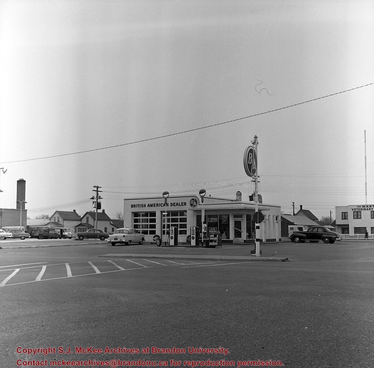
Mansfield's Western Shop was located on the corner of 6th Street and Princess Avenue at 603 Princess Avenue. The business appears to have been opened in 1966 by Ed and Jessie Mansfield. The shop was originally owened by Norman D. Moore and was called Moore's Western Shop. According to the Henderson's Brandon City Directory Mansfield's was relocated several times during its ownership. In 1967 Mansfields was reloacted to 737 11th Street, by 1973 had relocated again to 731 Princess Avenue and remained there until at least 1984. Mansfield's Western Shop had moved to it's final location at 1130 18th Street by 1988. Once Ed and Jessie retired the shop was taken over by their sons Les and Lyle Mansfield. Les and Lyle closed the store when they retired in 2015. Presently (2020) the H&Co Acadamy building stands where the original Mansfields Western Shop stood on 6th Street.
Custodial History
See Fonds level description for custodial history
Scope and Content
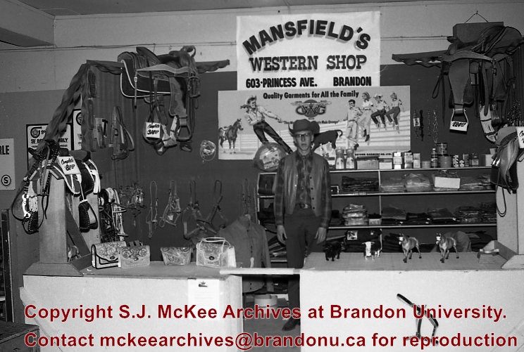
Image of the interior of Mansfield's Western Shop. The image is of a man standing behind the counter in dressed in a western style. The man could possibly be Ed Mansfield. There are various items displayed around the counter including: saddles, tack, figurines, clothing and hand bags. Above him is a sign that reads "Mansfield's Western Shop 603 Princess Ave. Brandon".
Notes
Hisotry/Bio information taken from Henderson's Directories. Description by Jillian Combs.
View is southwest from approximatley 16th Street between Lorne Avenue and Princess Avenue. The view extends to approximately 26th Street. Photograph shows the Brandon University campus, Kinsmen Stadium, Fleming School, Coronation Park and residential blocks.
The photograph was taken for the Centennial of Brandon College/University.
Scope and Content
Aerial photograph taken looking southwest from approximately the northeast corner of Princess Avenue and 17th Street. The entire campus, as well as a number of residential streets are visible.


)
)
)