Radiocarbon date reports have been scanned in multi-page PDF files.
History / Biographical
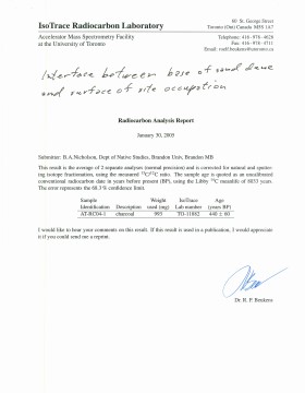
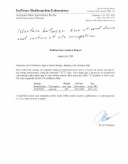
North Lauder Radiocarbon Date report by IsoTrace Laboratory for Atkinson II site #TO-11882.
Radiocarbon dating
The technique of radiocarbon dating was developed by Willard Libby and his colleagues at the University of Chicago in 1949.
Radiocarbon dating is used to estimate the age of organic remains from archaeological sites. Organic matter has a radioactive form of carbon (C14) that begins to decay upon death. C14 decays at a steady, known rate of a half life of 5,730 years. The technique is useful for material up to 50,000 years. Fluctuations of C14 in the atmosphere can affect results so dates are calibrated against dendrochronology. Radiocarbon dates are calibrated to calendar years.
Dates are reported in radiocarbon years or Before Present. Before Present refers to dates before 1950. The introduction of massive amounts of C14, due to atomic bomb and surface testing of atomic weapons, has widely increased the standard deviation on all dates after A.D. 1700 causing these dates to be unreliable.
Accelerated mass spectrometry can more accurately measure C14 with smaller samples and can date materials to 80,000 years.
Scope and Content
Sub sub series contains radiocarbon dates from: Atkinson site and Flintstone Hill.
Radiocarbon date reports have been scanned in multi-page PDF files.
History / Biographical
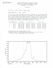
North Lauder Radiocarbon Date report by IsoTrace Laboratory for Atkinson site #TO-10640.
Radiocarbon dating
The technique of radiocarbon dating was developed by Willard Libby and his colleagues at the University of Chicago in 1949.
Radiocarbon dating is used to estimate the age of organic remains from archaeological sites. Organic matter has a radioactive form of carbon (C14) that begins to decay upon death. C14 decays at a steady, known rate of a half life of 5,730 years. The technique is useful for material up to 50,000 years. Fluctuations of C14 in the atmosphere can affect results so dates are calibrated against dendrochronology. Radiocarbon dates are calibrated to calendar years.
Dates are reported in radiocarbon years or Before Present. Before Present refers to dates before 1950. The introduction of massive amounts of C14, due to atomic bomb and surface testing of atomic weapons, has widely increased the standard deviation on all dates after A.D. 1700 causing these dates to be unreliable.
Accelerated mass spectrometry can more accurately measure C14 with smaller samples and can date materials to 80,000 years.
Scope and Content
Sub sub series contains radiocarbon dates from: Atkinson site and Flintstone Hill.
Radiocarbon date reports have been scanned in multi-page PDF files.
History / Biographical
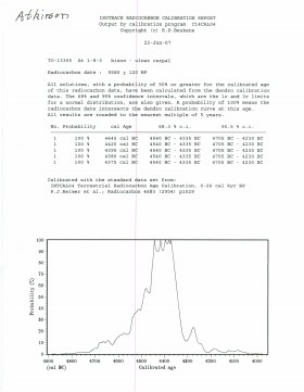
North Lauder Radiocarbon Date report by IsoTrace Laboratory for Atkinson site #TO-13365.
Radiocarbon dating
The technique of radiocarbon dating was developed by Willard Libby and his colleagues at the University of Chicago in 1949.
Radiocarbon dating is used to estimate the age of organic remains from archaeological sites. Organic matter has a radioactive form of carbon (C14) that begins to decay upon death. C14 decays at a steady, known rate of a half life of 5,730 years. The technique is useful for material up to 50,000 years. Fluctuations of C14 in the atmosphere can affect results so dates are calibrated against dendrochronology. Radiocarbon dates are calibrated to calendar years.
Dates are reported in radiocarbon years or Before Present. Before Present refers to dates before 1950. The introduction of massive amounts of C14, due to atomic bomb and surface testing of atomic weapons, has widely increased the standard deviation on all dates after A.D. 1700 causing these dates to be unreliable.
Accelerated mass spectrometry can more accurately measure C14 with smaller samples and can date materials to 80,000 years.
Scope and Content
Sub sub series contains radiocarbon dates from: Atkinson site and Flintstone Hill.
Radiocarbon date reports have been scanned in multi-page PDF files.
History / Biographical
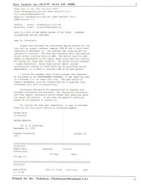
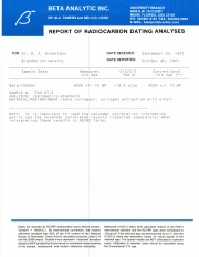
North Lauder Radiocarbon Date report by Beta Analytic Inc. for Flintstone Hill #109529 and #109530.
Radiocarbon dating
The technique of radiocarbon dating was developed by Willard Libby and his colleagues at the University of Chicago in 1949.
Radiocarbon dating is used to estimate the age of organic remains from archaeological sites. Organic matter has a radioactive form of carbon (C14) that begins to decay upon death. C14 decays at a steady, known rate of a half life of 5,730 years. The technique is useful for material up to 50,000 years. Fluctuations of C14 in the atmosphere can affect results so dates are calibrated against dendrochronology. Radiocarbon dates are calibrated to calendar years.
Dates are reported in radiocarbon years or Before Present. Before Present refers to dates before 1950. The introduction of massive amounts of C14, due to atomic bomb and surface testing of atomic weapons, has widely increased the standard deviation on all dates after A.D. 1700 causing these dates to be unreliable.
Accelerated mass spectrometry can more accurately measure C14 with smaller samples and can date materials to 80,000 years.
Scope and Content
Sub sub series contains radiocarbon dates from: Atkinson site and Flintstone Hill.
Radiocarbon date reports have been scanned in multi-page PDF files.
History / Biographical
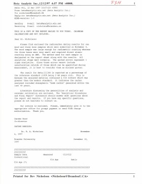
North Lauder Radiocarbon Date report by Beta Analytic Inc. for Flintstone Hill #111142 and #111143.
Radiocarbon dating
The technique of radiocarbon dating was developed by Willard Libby and his colleagues at the University of Chicago in 1949.
Radiocarbon dating is used to estimate the age of organic remains from archaeological sites. Organic matter has a radioactive form of carbon (C14) that begins to decay upon death. C14 decays at a steady, known rate of a half life of 5,730 years. The technique is useful for material up to 50,000 years. Fluctuations of C14 in the atmosphere can affect results so dates are calibrated against dendrochronology. Radiocarbon dates are calibrated to calendar years.
Dates are reported in radiocarbon years or Before Present. Before Present refers to dates before 1950. The introduction of massive amounts of C14, due to atomic bomb and surface testing of atomic weapons, has widely increased the standard deviation on all dates after A.D. 1700 causing these dates to be unreliable.
Accelerated mass spectrometry can more accurately measure C14 with smaller samples and can date materials to 80,000 years.
Scope and Content
Sub sub series contains radiocarbon dates from: Atkinson site and Flintstone Hill.
Radiocarbon date reports have been scanned in multi-page PDF files.
History / Biographical
North Lauder Radiocarbon Date report by Beta Analytic Inc. for Flintstone Hill #109900.
Radiocarbon dating
The technique of radiocarbon dating was developed by Willard Libby and his colleagues at the University of Chicago in 1949.
Radiocarbon dating is used to estimate the age of organic remains from archaeological sites. Organic matter has a radioactive form of carbon (C14) that begins to decay upon death. C14 decays at a steady, known rate of a half life of 5,730 years. The technique is useful for material up to 50,000 years. Fluctuations of C14 in the atmosphere can affect results so dates are calibrated against dendrochronology. Radiocarbon dates are calibrated to calendar years.
Dates are reported in radiocarbon years or Before Present. Before Present refers to dates before 1950. The introduction of massive amounts of C14, due to atomic bomb and surface testing of atomic weapons, has widely increased the standard deviation on all dates after A.D. 1700 causing these dates to be unreliable.
Accelerated mass spectrometry can more accurately measure C14 with smaller samples and can date materials to 80,000 years.
Scope and Content
Sub sub series contains radiocarbon dates from: Atkinson site and Flintstone Hill.
Hubert Clayton Weidenhamer was born near Dand, Manitoba in 1926. He was raised in Dand and attended school in the Dand Consolidated School District. Weidenhamer enlisted in the Canadian Army in 1943. He became a member of the Priness Patricia's Canadian Light Infantry. Following training in Canada and England Weidenhamer was sent to Italy. He was badly wounded in battle in mid-September and died of his injuries in November 1944 at age 21. He was buried in the Ancona Military Cemetery, Ancona Italy.
Custodial History
These records were in the possession of Bea Chapin (née Weidenhamer) following their creation in the 1940s until they were donated to the S. J. McKee Archives in January 2011.
Scope and Content
Collection consists of correspondence from Hubert Clayton Weidenhamer to his sister Bea. The letters begin in the spring of 1943. Weidenhamer had enlisted in the Canadian Army in January 1943. His letters detail his induction into miltary life in Fort Garry, Winnipeg and his training experience in Canada, principally at Camp Ipperwash, Lambton County, Ontario. He relates his experience of travels on leave to Detriot. Weidenhamer left Canada from Halifax in late 1943 and arrived in Great Britain in December for additional military training. In England, maintaining his morale, waiting for deployment, and coming to terms with British currency were challenges. Transferred to the Princess Patricia's Canadian Light Infantry, Weidenhamer was deployed to Italy in March 1944. The letters dating from March 1944 to September relate in oblique fashion his's experience of military life on the Italian frontier as the Canadian Army fought its way north - "hard fighting" - and the impact of the war on Italian cities and the countryside. He was "proud" of his conduct in action. Weidenhamer's last letter is dated September 11, 1944.
Collection also includes correspondence on Weidenhamer's behalf from his military Chaplin; two press clippings dealing with his military career, and several facimiles of telegrams and correspondence from the Canadian government officials related to Weidenhamer's death and burial in Italy.
The Lovstrom surface collection came from small fields cleared within, and adjacent to, the major portions of the site which were excavated. The Lovstroms initial collection has since been added to by field personnel from Brandon University. The initial collections consisted of lithics and ceramics. A collection of faunal remains from the cultivated area was made by a Brandon University zooarchaeology class in 1986 which yielded specimens of elk, canid, mussels, and sucker, in addition to an expected abundance of bison. Since these materials were in a surface context, it may be that some of the faunal remains were historic.
The high biodiversity and evidence of pre-Europeon contact prompted the decision to test the Lovstrom locale. Nine 1m2 units were excavated in 1985 and, in 1986, an additional 15 1m2 units were excavated for a total of 24 test units. This testing indicated the presence of a large precontact locale with lithics, woodland ceramics and large amounts of reasonably well-preserved faunal materials.
The lithics indicated a late Prehistoric occupation (Nicholson 1986:35). However, the ceramics were more useful in that they identified the presence of Late Woodland cultures (Blackduck and Duckbay) and a single Middle Missouri vessel. It is believed that the Middle Missouri vessel was imported since the paste and construction/decorative technology differ distinctively from that of all other vessels recovered from the site. It was on the basis of an examination of these surface finds that the decision to test the Lovstrom site was made. These test excavations were conducted during the summers of 1985 and 1986.
Field investigations through shovel tests, excavation units, and examination of rodent mounds, indicated that the cultural deposits at the Lovstrom locale extend approximately 500m north from the edge of the Souris channel and eastward for over two hundred meters from the escarpment along Jock’s Creek. The presence of dense forest vegetation covering much of the locale, and the subsurface nature of the archaeological deposits obscured surface indications.
Radiocarbon dates: Test Unit 4: 1215/320 BP and Test Unit 8 1280/190 BP
Scope and Content
Sub-series has been divided into sub sub series including: Lovstrom survey 1985 and Lovstrom survey 1986
Field journals have been scanned in multi-page PDF files. Artifact catalogues are PDF files in spreadsheet format. Photographs are in jpeg format.
History / Biographical
Directed by Dr. Nicholson, a crew of five students from Brandon University under the supervision of Dr. Scott Hamilton excavated a total of 9 units in 1985. This testing indicated the presence of artifacts manufactured by Blackduck and Duckbay peoples from the boreal forest and northern parkland areas. Other ceramics diagnostic of groups from the Saskatchewan Basin and the Middle Missouri area were also recovered in surface collection from the cultivated area of the locale.
Scope and Content
Sub-sub-sub series contains: Summary information of field methology, number and co-ordinates of excavations, personnel and their staff position; Field journals are daily records of recoveries, features and activities at the site; Site records include excavation level and unit summaries, feature sheets, profiles; sample records and maps; Artifact catalogues are lists and identifications of all artifacts recovered; Photographs are of excavation units, features, the landscape and personnel.
Field journals have been scanned in multi-page PDF files. Artifact catalogues are PDF files in spreadsheet format. Photographs are in jpeg format.
History / Biographical
Directed by Dr. Nicholson with Brenda Kramarchuck as crew chief, two students from Brandon University were hired to excavate an additional sample of 15 1m2 units in 1986. This work confirmed the results of the first season, and resulted in an increased sample of faunal material, lithics, ceramics, and in the identification of distinctive ceramic clusters from different locations within the locale. These two seasons of testing satisfactorily demonstrated the presence of a large Prehistoric locale containing the remains of Late Woodland occupation which included lithics, ceramics and reasonably well preserved faunal remains.
Scope and Content
Sub-sub-sub series contains: Summary information of field methology, number and co-ordinates of excavations, personnel and their staff position; Field journals are daily records of recoveries, features and activities at the site; Site records include excavation level and unit summaries, feature sheets, profiles; sample records and maps; Artifact catalogues are lists and identifications of all artifacts recovered; Photographs are of excavation units, features, the landscape and personnel.
Block A was the most southern site in the locale. The excavation block consisted of 12 contiguous 1m2 units dug in a 3m x 4m rectangle. The block was the least productive of cultural materials, and bone preservation was the poorest. Under the sod, the black loam layer appeared at 5 cm below surface, and the glacial clay at 25 cm below surface. Excavators described the soil matrix as gritty and silty, and it became concrete hard when dried.
The occupation or bone layer extended from 10 to 25 cm below surface and consisted of a contiguous scatter of FCR and unidentifiable large ungulate bone which was heavily processed and intensively scavenged by carnivores. Most cultural materials were recovered within this layer. Fire cracked rock (FCR) and small burnt bone fragments were present but no intact hearths or processing features were evident.
Non-cultural materials included limestone and other natural pebbles derived from the parent till. (These small limestone pebbles were apparent in the occupation layers in other blocks as well). Root and rodent disturbance was extensive throughout Block A. Most units were excavated to gravelly clay till. Nine of the twelve units were dug to level 4b, which ended at 40 cm b.s.
No further excavations were done at this site. No C14 dates were taken.
Scope and Content
Sub-sub-sub series contains: Summary information of field methology, number and co-ordinates of excavations, personnel and their staff position; Field journals are daily records of recoveries, features and activities at the site; Site records include excavation level and unit summaries, feature sheets, profiles; sample records and maps; Artifact catalogues are lists and identifications of all artifacts recovered; Photographs are of excavation units, features, the landscape and personnel.
Block B consisted of 20 contiguous 1m2 units excavated to 30 cm below surface. (except unit 58 which was excavated to 35 cm bs to obtain extended soil profile). The block is situated in recent oak and poplar forest at the head of a ravine leading to Jock’s Creek, adjacent to an area cleared for market gardening. As was the case with Block A, the understory is heavily overgrown with hazelnut, chokecherry, saskatoon, and a poison ivy/sarsaparilla ground cover.
The soil levels below the sod in Block B consisted of a black, silty, and gritty loam layer from 5 cm to 23 cm below surface, a yellow and sandy clay from 23 cm to 30 cm below surface, and glacial till at 30 cm below surface. As in Block A, limestone cobbles were found throughout the occupation level around the bone. It is evident that bioturbation – primarily tree roots and rodent burrowing – have significantly altered patterns of original deposition of lithics, ceramics and small bone.
The faunal layer lay close to the surface, situated entirely in the black loam 5 cm – 23 cm below surface. The 23 cm depth also marked the end of the dark silty loam. At 10 cm below surface, a discernible patterning of the bone appeared. Concentrations of bone in narrow rows ran in an irregular pattern from the northwest to the southeast part of the block. This pattern was most apparent in the north end of the block which is the highest point in the block. In the same 1m2 unit, patches of weathered, very poorly preserved bone would be found lying close to patches of well preserved bone. It is believed that this variability in preservation results from uneven rates of burial due to taphic activities of pocket gophers or other agents of bioturbation. The same pattern of uneven preservation occurs over much of the locale but is most evident in Block B.
Diagnostic lithics included eleven projectile points that were predominantly Plains or Prairie Side-notch types, but included two unnotched triangular points. Cord-wrapped impressed rim sherds and body sherds were recovered. The ceramics are variants of the Woodland Blackduck horizon.
RC dates: XU49 – 675/80 BP XU 59 – 705/75BP.
Scope and Content
Sub-sub-sub series contains: Summary information of field methology, number and co-ordinates of excavations, personnel and their staff position; Field journals are daily records of recoveries, features and activities at the site; Site records include excavation level and unit summaries, feature sheets, profiles; sample records and maps; Artifact catalogues are lists and identifications of all artifacts recovered; Photographs are of excavation units, features, the landscape and personnel.
Block C was situated in sparse oak forest with an understory of saskatoon, hazelnut and a thick ground cover of poison ivy and sarsaparilla. The block measured 3m and 3m and contained nine excavation units. All units were excavated to 35cm below surface. The soil horizons were much like the other blocks, except for a rusty brown stain in the first level, giving the upper black loam a mottled appearance. The brown patches were clay mixed with loam and were harder than the surrounding matrix. No definitive interpretation of these phenomena was attempted but this effect may be the result of natural brush or forest fires. Under the 5cm so d/humus (Ah) layer, the loam horizon extended approximately 5cm – 25 cm below surface, and averaged 20 cm thick. Bone was concentrated within this horizon between 10 cm – 20 cm below surface.
Block C was notable for its concentrations of articulated bison bone. Most noteworthy was an articulated unit composed of lumbar vertebrae, pelvis, and sacrum. Several thoracic vertebra/proximal rib end concentrations were also recovered. There were more vertebrae and rib sections recovered in the units in proportion to other bones. A few sherds, some debitage and a single Prairie Side-Notched point fragment were among the recoveries. Based on the quantity of bone, the density of the bone layer, and the articulated butchering units the area has been interpreted as a bone midden.
Faunal material was analysed by Jessica MacKenzie for her Honours Thesis: "A reconstruction of butchering processes in Block C from the Lovstrom site DjLx-1 in Southwestern Manitoba."
Radiocarbon date: 850/115BP XU 79.
Scope and Content
Sub-sub-sub series contains: Summary information of field methology, number and co-ordinates of excavations, personnel and their staff position; Field journals are daily records of recoveries, features and activities at the site; Site records include excavation level and unit summaries, feature sheets, profiles; sample records and maps; Artifact catalogues are lists and identifications of all artifacts recovered; Photographs are of excavation units, features, the landscape and personnel.
Field journals have been scanned in multi-page PDF files. Artifact catalogues are PDF files in spreadsheet format. Photographs are in jpeg format.
History / Biographical
Archaeological testing began in the Crepeele locale in May 2003 with a field crew of four members. James Graham supervised the crew and was assisted by Sarah Graham, Jollana Bishop, and Lisa Sonnenburg. Later additions to the testing team were Todd Kristensen, Michael Evans, and Emily Ansell.
The methodology for this survey used an arbitrary datum and a transit to establish a grid of 30 m intervals and a shovel test every 20 m. Materials were removed and screened to a minimum depth of 50 cm below surface. All recovered materials were bagged and removed to the lab for further analysis. All information including: test pit grid co-ordinates; UTM co-ordinates for each test pit; artifact presence; excavator; vegetation; aspect; paleosol; paleosol depth; and notes, were entered into a GIS database.
Approximately 600 shovel test pits were excavated and recorded in this fashion. Of the 600 shovel test pits, over 300 contained cultural materials. Based on the results of the Casselman survey several areas were designed for further testing and excavation. Crepeele West and Crepeele East were renamed the Sarah site DiMe-28) and Crepeele 3 which became the Crepeele site DiMe- 29.
Scope and Content
Sub-sub-sub series contains: Summary information of field methology, number and co-ordinates of excavations, personnel and their staff position; Field journalsare daily records of recoveries, features and activities at the site; Site records include excavation level and unit summaries, feature sheets, profiles; sample records and maps; Artifact catalogues are lists and identifications of all artifacts recovered; Photographs are of excavation units, features, the landscape and personnel.
Field journals have been scanned in multi-page PDF files. Artifact catalogues are PDF files in spreadsheet format. Photographs are in jpeg format.
History / Biographical
The Crepeele site was identified from the results of the Casselman survey and excavated in 2003. In 2004 the site was funded through the SCAPE project, directed by Bev Nicholson. The units were excavated by Crew Chief Tomasin Playford and crew.
Eight units were excavated in 2004, XU 1to XU 8
The artifacts recovered from these eight excavations are faunal (animal bone), mainly bison, lithic materials (stone tools and flakes) and some ceramic (pottery). The artifact catalogue has 1258 records.
Scope and Content
Sub-sub-sub series contains: Summary information of field methology, number and co-ordinates of excavations, personnel and their staff position; Field journalsare daily records of recoveries, features and activities at the site; Site records include excavation level and unit summaries, feature sheets, profiles; sample records and maps; Artifact catalogues are lists and identifications of all artifacts recovered; Photographs are of excavation units, features, the landscape and personnel.
Field journals have been scanned in multi-page PDF files. Artifact catalogues are PDF files in spreadsheet format. Photographs are in jpeg format.
History / Biographical
The Crepeele site was identified from the results of the Casselman survey and excavated in 2003 and 2004.
In 2005 the Brandon University Field School was held at both the Crepeele and Graham sites in the Crepeele locale. Denise Ens instructed the school and James Graham was teaching assistant.
At the Crepeele site nine units were excavated (XU10-16 & 20, 21). Units 20 & 21 were referred to as Meadow in the notes but is considered part of the larger site based on recoveries. There are over 1,570 records in the catalogue. Faunal (animal bone), lithics, fire cracked rock, diagnostic lithics and ceramics were recovered from the site
The weather conditions during the field school were particularly difficult due to the rainfall and flooding of the roads and sites.
Scope and Content
Sub-sub-sub series contains: Summary information of field methology, number and co-ordinates of excavations, personnel and their staff position; Field journalsare daily records of recoveries, features and activities at the site; Site records include excavation level and unit summaries, feature sheets, profiles; sample records and maps; Artifact catalogues are lists and identifications of all artifacts recovered; Photographs are of excavation units, features, the landscape and personnel.
Field journals have been scanned in multi-page PDF files. Artifact catalogues are PDF files in spreadsheet format. Photographs are in jpeg format.
History / Biographical
The Crepeele site was identified from the results of the Casselman survey and excavated in 2003, 2004 and 2005.
In 2007 the Brandon University Archaeology Field School was held at the Crepeele site in the Crepeele locale. Denise Ens instructed the school with Kate Decter & Jessica MacKenzie assistants.
Seventeen units were excavated XU30 - 46. Faunal (animal bone), lithics, fire cracked rock, diagnostic lithics and ceramics were recovered from the site. There are over 3050 records in the catalogue.
Scope and Content
Sub-sub-sub series contains: Summary information of field methology, number and co-ordinates of excavations, personnel and their staff position; Field journalsare daily records of recoveries, features and activities at the site; Site records include excavation level and unit summaries, feature sheets, profiles; sample records and maps; Artifact catalogues are lists and identifications of all artifacts recovered; Photographs are of excavation units, features, the landscape and personnel.
Field journals have been scanned in multi-page PDF files. Artifact catalogues are PDF files in spreadsheet format. Photographs are in jpeg format.
History / Biographical
The Crepeele site was identified from the results of the Casselman survey and excavated in 2003, 2004, 2005 and 2007. In 2005 and 2007 the Brandon University Archaeology Field School was held at the Crepeele site in the Crepeele locale.
In 2008 a small crew returned to the site to gather further samples and verify profiles. Three units (XU 50, 51 and 52) were excavated with faunal (animal bone), lithics, fire cracked rock, diagnostic lithics and ceramics recovered from the site. There are 455 records in the artifact catalogue.
Scope and Content
Sub-sub-sub series contains: Summary information of field methology, number and co-ordinates of excavations, personnel and their staff position; Field journalsare daily records of recoveries, features and activities at the site; Site records include excavation level and unit summaries, feature sheets, profiles; sample records and maps; Artifact catalogues are lists and identifications of all artifacts recovered; Photographs are of excavation units, features, the landscape and personnel.
The Sarah site was chosen for excavation based on the results of the Casselman survey. The survey recovered significant amounts of faunal remains, some ceramics and lithics from the test pits. Excavations took place in 2003 at Crepeele West (Units 1-5) and Crepeele East (Units 6-9). The site was subsequently renamed the Sarah site DiMe-28. In 2004 another 9 units were excavated (Units 10-18).
Based on the recoveries it was determined that the Sarah site is a stratified site with woodland ceramics in the upper occupation and late woodland points in both of the upper occupations. These upper occupations produced abundant bison bone including foetal bone. The lower occupations produced less bone and no foetal bone, although absence of foetal bone in the lower occupations does not necessarily indicate a warm season occupation. This could be due to sample error or perthotaxic factors such as scavenging of the fragile bone by dogs or other carnivores.
The dates from the Sarah site include 550+/-40 B.P.; 1430+/-80 B.P; 2810+/-80 B.P.; 3120+/-130 B.P. The lower occupations did not yield any diagnostic materials although debitage was abundant. These occupations were most productive at the edge of the large sand dune at the southern edge of the excavations. It is assumed that the major portion of these occupations have been overridden by the dune in the past 3000 years. Heavy earthmoving equipment would be required to remove this overburden which limits the possibility of future excavation.
Environment
The Sarah site is a large area located at the eastern end of the Crepeele locale. Ground cover is a mosaic of aspen poplar groves and patches of mesic grass prairie. Excavation profiles indicate that this has been the situation since early precontact times, although as local climatic conditions change (primarily rainfall), the relative size of these areas and where they may have occurred also changed. The soil is aeolian sand sheet derived from delta outwash deposits along the western edge of glacial Lake Hind. The present topography is a variable dune landscape reworked by aeolian activity that creates a mosaic of microhabitats. These include forested patches in the lee of sand dunes with grassland on the southern and western exposures and small damp lowlands that support balsam poplar, willows, red osier dogwood, high-bush cranberry and water birch. There is no permanent water source in the area although a small seasonal stream meanders through a damp lowland to the east of the Sarah site.
Scope and Content
Sub-series has been divided into sub sub series including: Sarah 2003 and Sarah 2004,
Field journals have been scanned in multi-page PDF files. Artifact catalogues are PDF files in spreadsheet format. Photographs are in jpeg format.
History / Biographical
The Sarah site was chosen for excavation based on the results of the Casselman survey. The survey recovered significant amounts of faunal remains, some ceramics and lithics from the test pits. Excavations took place in 2003 at Crepeele West (Units 1-5) and Crepeele East (Units 6-9). The site was subsequently renamed the Sarah site DiMe-28.
Units 1 to 9 were excavated by supervisor James Graham and crew of Sarah Graham, Mike Evans, Todd Kristensen, Shayne Kolesar, Lisa Sonnenburg and Emily Ansell.
Scope and Content
Sub-sub-sub series contains: Summary information of field methology, number and co-ordinates of excavations, personnel and their staff position; Field journalsare daily records of recoveries, features and activities at the site; Site records include excavation level and unit summaries, feature sheets, profiles; sample records and maps; Artifact catalogues are lists and identifications of all artifacts recovered; Photographs are of excavation units, features, the landscape and personnel.