Skip header and navigation

Revise Search

2016 records – page 3 of 101.

Brandon College campus

http://archives.brandonu.ca/en/permalink/descriptions819
Part Of
Aerial views and campus photographs
Description Level
Item
GMD
graphic
Date Range
c. 1960s
Part Of
Aerial views and campus photographs
Description Level
Item
Series Number
2.1
Item Number
2.1.51
GMD
graphic
Date Range
c. 1960s
Physical Description
10" x 8" (b/w)
Scope and Content
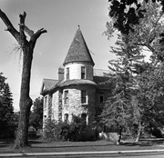
View is southwest. Photograph shows Clark Hall, the Brandon College Building, the Citizens' Science Building and the driveway running in front of the buildings. Portions of the front lawn and the Kinsmen Staduim are also visible.
Images
Show Less

Brandon University campus

http://archives.brandonu.ca/en/permalink/descriptions836
Part Of
Aerial views and campus photographs
Description Level
Item
GMD
graphic
Date Range
1977
Part Of
Aerial views and campus photographs
Description Level
Item
Series Number
2.1
Item Number
2.1.52
GMD
graphic
Date Range
1977
Physical Description
10" x 8" (b/w)
Scope and Content
View is northeast fron the west side of the Dining Hall. Photograph shows portions of the J.R.C. Evans Lecture Theatre and the A.E. McKenzie Building, as well as an H-Hut, Clark Hall, the Brandon College Building and the quadrangle.
Images
Show Less

Brandon University driveway

http://archives.brandonu.ca/en/permalink/descriptions841
Part Of
Aerial views and campus photographs
Description Level
Item
GMD
graphic
Date Range
c. 1980s
Part Of
Aerial views and campus photographs
Description Level
Item
Series Number
2.1
Item Number
2.1.35
GMD
graphic
Date Range
c. 1980s
Physical Description
3.5" x 5" (b/w)
Scope and Content
View is north from approximately the Citizens' Science Building. Photograph shows the driveway running in front of the Brandon College Building and Clark Hall, a number of cars and students along the driveway and the Education Building in the background.
Images
Show Less

Brandon University campus

http://archives.brandonu.ca/en/permalink/descriptions850
Part Of
Aerial views and campus photographs
Description Level
Item
GMD
graphic
Date Range
May 1978
Part Of
Aerial views and campus photographs
Description Level
Item
Series Number
2.1
Item Number
2.1.36
GMD
graphic
Date Range
May 1978
Physical Description
5" x 3.5" (colour)
Scope and Content
View is northwest from the front lawn. Clark Hall and the Education Building are visible between the trees.
Images
Show Less

Brandon University campus

http://archives.brandonu.ca/en/permalink/descriptions866
Part Of
Aerial views and campus photographs
Description Level
Item
GMD
graphic
Date Range
October 1981
Part Of
Aerial views and campus photographs
Description Level
Item
Series Number
2.1
Item Number
2.1.37
GMD
graphic
Date Range
October 1981
Physical Description
3.5" x 5" (colour)
Scope and Content
View is south from the lawn in front of the Education Building and shows a student exiting the building. The driveway and John R. Brodie Science Centre are visible in the background.
Images
Show Less

Brandon University campus front lawn

http://archives.brandonu.ca/en/permalink/descriptions869
Part Of
Aerial views and campus photographs
Description Level
Item
GMD
graphic
Date Range
May 1978
Part Of
Aerial views and campus photographs
Description Level
Item
Series Number
2.1
Item Number
2.1.38
GMD
graphic
Date Range
May 1978
Physical Description
5" x 3.5" (colour)
Scope and Content
View is north encompassing the front lawn of the Brandon University campus. The Education Building can be seen in the background.
Show Less

Brandon College campus

http://archives.brandonu.ca/en/permalink/descriptions916
Part Of
Aerial views and campus photographs
Description Level
Item
GMD
graphic
Date Range
c. 1966
Part Of
Aerial views and campus photographs
Creator
Miles Photos
Description Level
Item
Series Number
2.1
Item Number
2.1.53
GMD
graphic
Date Range
c. 1966
Physical Description
10" x 8" (b/w)
Scope and Content
View is northwest from the front lawn. Photograph shows the Citizens' Science Building, an H-Hut, the Brandon College Building, Clark Hall and the original Music Building.
Images
Show Less

Brandon University campus

http://archives.brandonu.ca/en/permalink/descriptions917
Part Of
Aerial views and campus photographs
Description Level
Item
GMD
graphic
Date Range
c. 1967
Part Of
Aerial views and campus photographs
Description Level
Item
Series Number
2.1
Item Number
2.1.54
GMD
graphic
Date Range
c. 1967
Physical Description
10" x 8" (b/w)
Physical Condition
Photograph has a couple of cracks, due to bending.
Scope and Content
View is northwest from the front lawn. Photograph shows the Brandon College Building, Clark Hall, the parking lot in front of those two buildings and the Education building.
Images
Show Less

Proposed model of the Brandon University campus

http://archives.brandonu.ca/en/permalink/descriptions919
Part Of
Aerial views and campus photographs
Description Level
Item
GMD
graphic
Date Range
c. 1960s
Part Of
Aerial views and campus photographs
Description Level
Item
Series Number
2.1
Item Number
2.1.45
GMD
graphic
Date Range
c. 1960s
Physical Description
7" x 5" (b/w)
Scope and Content
A model of the proposed campus of Brandon University.
Show Less

Brandon College campus

http://archives.brandonu.ca/en/permalink/descriptions956
Part Of
Aerial views and campus photographs
Description Level
Item
GMD
graphic
Date Range
c. 1950s
Part Of
Aerial views and campus photographs
Description Level
Item
Series Number
2.1
Item Number
2.1.44
GMD
graphic
Date Range
c. 1950s
Physical Description
7" x 5" (b/w)
Scope and Content
View is south southwest from approximatley the location of the current Health Studies Complex. Photograph shows the large field to the north of Clark Hall, Clark Hall, the Brandon College Building, the Citizens' Science Building and an H-Hut behind Clark Hall.
Show Less

Brandon College campus from the north

http://archives.brandonu.ca/en/permalink/descriptions957
Part Of
Aerial views and campus photographs
Description Level
Item
GMD
graphic
Date Range
c. 1950s
Part Of
Aerial views and campus photographs
Description Level
Item
Series Number
2.1
Item Number
2.1.39
GMD
graphic
Date Range
c. 1950s
Physical Description
4.5" x 2.75" (b/w)
Scope and Content
View is southwest. Photograph shows: Clark Hall, the Brandon College Building and the Citizens' Science Building.
Images
Show Less

Brandon College ice skating rink

http://archives.brandonu.ca/en/permalink/descriptions959
Part Of
Aerial views and campus photographs
Description Level
Item
GMD
graphic
Date Range
c. 1920s/1930s
Part Of
Aerial views and campus photographs
Description Level
Item
Series Number
2.1
Item Number
2.1.43
GMD
graphic
Date Range
c. 1920s/1930s
Physical Description
6.25" x 4.5" (b/w)
Material Details
Photograph is a copy.
Scope and Content
View is west northwest, probably from the roof of the Brandon College Building. Photograph shows an ice skating rink located in the field west of the Brandon College Building and Clark Hall. Some houses are visible in the background.
Notes
Donated by: D. Sumner.
Images
Show Less

Northfield School and pony barn, 6 miles east of Wawanesa, Manitoba

http://archives.brandonu.ca/en/permalink/descriptions11105
Part Of
RG 11 Lawrence Stuckey fonds
Description Level
Item
GMD
graphic
Date Range
Oct. 28, 1979
Part Of
RG 11 Lawrence Stuckey fonds
Creator
L.A. Stuckey
Description Level
Item
Series Number
3.3
Item Number
1-2002.3.3.BSE[363a]
GMD
graphic
Date Range
Oct. 28, 1979
Physical Description
2.5" x 3"
Material Details
Negative
History / Biographical
Mr. Stuckey's notes: : Purchased by the Mooney family for use as a community center, after closure as a school.
Custodial History
For custodial history see the collection level description of the Lawrence Stuckey collection.
Scope and Content
Image of Northfield School and pony barn, 6 miles east of Wawanesa, Manitoba.
Notes
[Brandon SE includes communities south of Trans-Canada #1 highway and east of PTH #10.]
Name Access
Northfield School
Wawanesa, Manitoba
Subject Access
schools
barns
community centres
Storage Location
Lawrence Stuckey collection
Arrangement
[Mr. Stuckey put two negatives in the same envelope. We have separated them and numbered the negatives (363a) and (363b].
Images
Show Less

Northfield School and pony barn, 6 miles east of Wawanesa, Manitoba

http://archives.brandonu.ca/en/permalink/descriptions11113
Part Of
RG 11 Lawrence Stuckey fonds
Description Level
Item
GMD
graphic
Date Range
Oct. 28, 1979
Part Of
RG 11 Lawrence Stuckey fonds
Creator
L.A. Stuckey
Description Level
Item
Series Number
3.3
Item Number
1-2002.3.3.BSE[363b]
GMD
graphic
Date Range
Oct. 28, 1979
Physical Description
2.5" x 3.5"
Material Details
Negative
History / Biographical
Mr. Stuckey's notes: : Purchased by the Mooney family for use as a community center, after closure as a school.
Custodial History
For custodial history see the collection level description of the Lawrence Stuckey collection.
Scope and Content
Image of Northfield School and pony barn, 6 miles east of Wawanesa, Manitoba.
Notes
[Brandon SE includes communities south of Trans-Canada #1 highway and east of PTH #10.]
Name Access
Northfield School
Wawanesa, Manitoba
Subject Access
schools
community centres
Storage Location
Lawrence Stuckey collection
Arrangement
[Mr. Stuckey put two negatives in the same envelope. We have separated them and numbered the negatives (363a) and (363b].
Images
Show Less

Old houses, Morden, Manitoba

http://archives.brandonu.ca/en/permalink/descriptions11118
Part Of
RG 11 Lawrence Stuckey fonds
Description Level
Item
GMD
graphic
Date Range
July 16, 1977
Part Of
RG 11 Lawrence Stuckey fonds
Creator
L.A. Stuckey
Description Level
Item
Series Number
3.3
Item Number
1-2002.3.3.BSE[364a]
GMD
graphic
Date Range
July 16, 1977
Physical Description
2.5" x 2.5"
Material Details
Negative
Custodial History
For custodial history see the collection level description of the Lawrence Stuckey collection.
Scope and Content
Image of old houses, Morden, Manitoba.
Notes
[Brandon SE includes communities south of Trans-Canada #1 highway and east of PTH #10.]
Name Access
Morden, Manitoba
Subject Access
houses
Storage Location
Lawrence Stuckey collection
Arrangement
[Mr. Stuckey put six negatives in the same envelope. We have separated them and numbered the negatives (364a) to (364f].
Images
Show Less

Old houses, Morden, Manitoba

http://archives.brandonu.ca/en/permalink/descriptions11119
Part Of
RG 11 Lawrence Stuckey fonds
Description Level
Item
GMD
graphic
Date Range
July 16, 1977
Part Of
RG 11 Lawrence Stuckey fonds
Creator
L.A. Stuckey
Description Level
Item
Series Number
3.3
Item Number
1-2002.3.3.BSE[364b]
GMD
graphic
Date Range
July 16, 1977
Physical Description
2.5" x 2.25"
Material Details
Negative
Custodial History
For custodial history see the collection level description of the Lawrence Stuckey collection.
Scope and Content
Image of old houses, Morden, Manitoba.
Notes
[Brandon SE includes communities south of Trans-Canada #1 highway and east of PTH #10.]
Name Access
Morden, Manitoba
Subject Access
houses
Storage Location
Lawrence Stuckey collection
Arrangement
[Mr. Stuckey put six negatives in the same envelope. We have separated them and numbered the negatives (364a) to (364f].
Images
Show Less

Old houses, Morden, Manitoba

http://archives.brandonu.ca/en/permalink/descriptions11124
Part Of
RG 11 Lawrence Stuckey fonds
Description Level
Item
GMD
graphic
Date Range
July 16, 1977
Part Of
RG 11 Lawrence Stuckey fonds
Creator
L.A. Stuckey
Description Level
Item
Series Number
3.3
Item Number
1-2002.3.3.BSE[364c]
GMD
graphic
Date Range
July 16, 1977
Physical Description
2.5" x 2.5"
Material Details
Negative
Custodial History
For custodial history see the collection level description of the Lawrence Stuckey collection.
Scope and Content
Image of old houses, Morden, Manitoba.
Notes
[Brandon SE includes communities south of Trans-Canada #1 highway and east of PTH #10.]
Name Access
Morden, Manitoba
Subject Access
houses
Storage Location
Lawrence Stuckey collection
Arrangement
[Mr. Stuckey put six negatives in the same envelope. We have separated them and numbered the negatives (364a) to (364f].
Images
Show Less

Old houses, Morden, Manitoba

http://archives.brandonu.ca/en/permalink/descriptions11125
Part Of
RG 11 Lawrence Stuckey fonds
Description Level
Item
GMD
graphic
Date Range
July 16, 1977
Part Of
RG 11 Lawrence Stuckey fonds
Creator
L.A. Stuckey
Description Level
Item
Series Number
3.3
Item Number
1-2002.3.3.BSE[364d]
GMD
graphic
Date Range
July 16, 1977
Physical Description
2.5" x 2.5"
Material Details
Negative
Custodial History
For custodial history see the collection level description of the Lawrence Stuckey collection.
Scope and Content
Image of old houses, Morden, Manitoba.
Notes
[Brandon SE includes communities south of Trans-Canada #1 highway and east of PTH #10.]
Name Access
Morden, Manitoba
Subject Access
houses
Storage Location
Lawrence Stuckey collection
Arrangement
[Mr. Stuckey put six negatives in the same envelope. We have separated them and numbered the negatives (364a) to (364f].
Images
Show Less

Old houses, Morden, Manitoba

http://archives.brandonu.ca/en/permalink/descriptions11126
Part Of
RG 11 Lawrence Stuckey fonds
Description Level
Item
GMD
graphic
Date Range
July 16, 1977
Part Of
RG 11 Lawrence Stuckey fonds
Creator
L.A. Stuckey
Description Level
Item
Series Number
3.3
Item Number
1-2002.3.3.BSE[364e]
GMD
graphic
Date Range
July 16, 1977
Physical Description
2.5" x 2.5"
Material Details
Negative
Custodial History
For custodial history see the collection level description of the Lawrence Stuckey collection.
Scope and Content
Image of old houses, Morden, Manitoba.
Notes
[Brandon SE includes communities south of Trans-Canada #1 highway and east of PTH #10.]
Name Access
Morden, Manitoba
Subject Access
houses
Storage Location
Lawrence Stuckey collection
Arrangement
[Mr. Stuckey put six negatives in the same envelope. We have separated them and numbered the negatives (364a) to (364f].
Images
Show Less

Old houses, Morden, Manitoba

http://archives.brandonu.ca/en/permalink/descriptions11127
Part Of
RG 11 Lawrence Stuckey fonds
Description Level
Item
GMD
graphic
Date Range
July 16, 1977
Part Of
RG 11 Lawrence Stuckey fonds
Creator
L.A. Stuckey
Description Level
Item
Series Number
3.3
Item Number
1-2002.3.3.BSE[364f]
GMD
graphic
Date Range
July 16, 1977
Physical Description
2.5" x 2.5"
Material Details
Negative
Custodial History
For custodial history see the collection level description of the Lawrence Stuckey collection.
Scope and Content
Image of old houses, Morden, Manitoba.
Notes
[Brandon SE includes communities south of Trans-Canada #1 highway and east of PTH #10.]
Name Access
Morden, Manitoba
Subject Access
houses
Storage Location
Lawrence Stuckey collection
Arrangement
[Mr. Stuckey put six negatives in the same envelope. We have separated them and numbered the negatives (364a) to (364f].
Images
Show Less

2016 records – page 3 of 101.