These blocks of ice were used to fill the ice houses of the Wheat City Ice Co. (located north of Rosser Avenue on the west side of 15th Street, and south of Princess Avenue on the east side of 17th Street), the CPR icehouses (at the station and 3rd St. & Assiniboine Ave), and the CNR icehouse (at Forth Street and McTavish Avenue). In addition, large quantities of ice were shipped to smaller towns in railcars (usually old refrigerator cars).
Custodial History
For custodial history see the collection level description of the Lawrence Stuckey collection.
Scope and Content
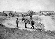
Cutting ice from the Assiniboine River
Notes
This is one of five images that show the method in which ice is cut into blocks and loaded onto sleighs or trucks. Note the large draft horses still in use at this date.
[Mr. Stuckey put five negatives into the same envelope. We have separated them and numbered them H12(1) to H12(5).]
Additional information provided by the Fred McGuinness collection (20-2009).
These blocks of ice were used to fill the ice houses of the Wheat City Ice Co. (located north of Rosser Avenue on the west side of 15th Street, and south of Princess Avenue on the east side of 17th Street), the CPR icehouses (at the station and 3rd St. & Assiniboine Ave), and the CNR icehouse (at Forth Street and McTavish Avenue). In addition, large quantities of ice were shipped to smaller towns in railcars (usually old refrigerator cars).
Custodial History
For custodial history see the collection level description of the Lawrence Stuckey collection.
Scope and Content
Cutting ice from the Assiniboine River
Notes
This is one of five images that show the method in which ice is cut into blocks and loaded onto sleighs or trucks. Note the large draft horses still in use at this date.
[Mr. Stuckey put five negatives into the same envelope. We have separated them and numbered them H12(1) to H12(5).]
Additional information provided by the Fred McGuinness collection (20-2009).
As a boy my father pointed out this pile of bricks, and pit beside it, and told me a small brick plant had been established here in the early days. The product was of poor quality and the business never became established. LAS.
Custodial History
For custodial history see the collection level description of the Lawrence Stuckey collection.
Scope and Content
Spring Park brick pile near the CPR grade
Notes
Located just south of the CPR mainline at Mile 3 [three miles west of Brandon. P.E.]
[Mr. Stuckey put three negatives in same envelope. We have separated them and numbered them H13(1), H13(2) and H13(3).]
As a boy my father pointed out an old pile of bricks, and pit beside it, and told me a small brick plant had been established here in the early days. The product was of poor quality and the business never became established. LAS.
Custodial History
For custodial history see the collection level description of the Lawrence Stuckey collection.
Scope and Content
Area nearby the Spring Park brick pile
Notes
Located just south of the CPR mainline at Mile 3 [three miles west of Brandon. P.E.]
[Mr. Stuckey put three negatives in same envelope. We have separated them and numbered them H13(1), H13(2) and H13(3).]
After demise of the streetcars, a transit system was started by MacArthur Transportation Co. with three routes, an east end loop, a south end loop, and a west end loop, with terminal at 8th St. & Rosser Ave. The E & W was operated as a continuous route with two locally built coach bodies on new Maple Leaf trucks. A secondhand, larger, Leland coach was acquired for the S. end, which was replaced by a large GMC about 1938.
Custodial History
For custodial history see the collection level description of the Lawrence Stuckey collection.
Photograph was in possession of Mrs. Ruby Miles, who passed the image on to Fred McGuinness. McGuinness makes reference to Mrs. Miles and this photograph in his Sunbeams column (Brandon Sun 14 September 1978).
Scope and Content
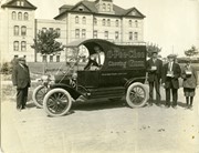
Photograph shows a truck advertising O-Pee-Chee Chewing Gum parked in front of Brandon College's Clark Hall. The truck has been identified in the Stuckey collection as a Ford "Model T" delivery wagon. Its windshield is covered with a large advertisement that says, "Equipped with Dunlop Traction Tread Tires." Its license plate reads 1913 #2945. The truck is facing south on 18th Street. A middle-aged man is standing in front of the wagon; a box of gum rests on the truck's right fender. The driver, sporting a gadsby cap and tie, is proping up a box of gum on the driver's side door. Three young men, wearing suits, ties, and gadsby caps, are standing behind the wagon while holding open boxes of chewing gum.
Notes
Writing on the back of the photograph reads: Mrs. R. Miles. The photograph is stamped Davidson & Gowen, Photographers, Brandon, Man.
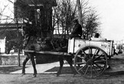
William A. Fleming, Brandon's first water dealer, is said to have begun his business in 1881. He sold drinking water for 5 cents per pail from the 1920s through the mid 1930s. The source of his water was a well located on the east side of the 100 block of 12th Street. Fleming's business was taken over by two men with a water tank on a truck, and continued till 1946 when it was closed due to contamination.
Custodial History
For custodial history see the collection level description of the Lawrence Stuckey collection.
Scope and Content
Mr. Wm. Fleming, Water Dealer, with horse and water cart
Notes
Ad on cart: W.H. Mallett Jeweller Issuer of Marriage Licenses.
Photo courtesy of the Assiniboine Historical Society.
.jpg?width=1200&404=no-img.jpg&watermark=wmk)
.jpg?width=180&404=no-img.jpg)
.jpg?width=1200&404=no-img.jpg&watermark=wmk)
.jpg?width=180&404=no-img.jpg)
.jpg?width=1200&404=no-img.jpg&watermark=wmk)
.jpg?width=180&404=no-img.jpg)
.jpg?width=1200&404=no-img.jpg&watermark=wmk)
.jpg?width=180&404=no-img.jpg)
.jpg?width=1200&404=no-img.jpg&watermark=wmk)
.jpg?width=180&404=no-img.jpg)
.jpg?width=1200&404=no-img.jpg&watermark=wmk)
.jpg?width=180&404=no-img.jpg)
.jpg?width=1200&404=no-img.jpg&watermark=wmk)
.jpg?width=180&404=no-img.jpg)
.jpg?width=1200&404=no-img.jpg&watermark=wmk)
.jpg?width=180&404=no-img.jpg)


.jpg%3fmaxheight%3d1000%26maxwidth%3d1000%26watermark%3dwmk&description=Cutting+Ice+from+the+Assiniboine+River)
.jpg%3fmaxheight%3d1000%26maxwidth%3d1000%26watermark%3dwmk&description=Cutting+Ice+from+the+Assiniboine+River)
.jpg%3fmaxheight%3d1000%26maxwidth%3d1000%26watermark%3dwmk&description=Cutting+Ice+from+the+Assiniboine+River)
.jpg%3fmaxheight%3d1000%26maxwidth%3d1000%26watermark%3dwmk&description=Cutting+Ice+from+the+Assiniboine+River)
.jpg%3fmaxheight%3d1000%26maxwidth%3d1000%26watermark%3dwmk&description=Cutting+Ice+from+the+Assiniboine+River)
.jpg%3fmaxheight%3d1000%26maxwidth%3d1000%26watermark%3dwmk&description=Spring+Park+Brick+Pile)
.jpg%3fmaxheight%3d1000%26maxwidth%3d1000%26watermark%3dwmk&description=Spring+Park+Brick+Pile)
.jpg%3fmaxheight%3d1000%26maxwidth%3d1000%26watermark%3dwmk&description=Spring+Park+Brick+Pile)
)
)
)
)