Skip header and navigation

Revise Search

125 records – page 3 of 7.

J.R.C. Evans Lecture Theatre and the link

http://archives.brandonu.ca/en/permalink/descriptions880
Part Of
Brandon University Photograph collection
Description Level
Item
GMD
graphic
Date Range
[196-]
Part Of
Brandon University Photograph collection
Creator
Photographer: Jerrett
Description Level
Item
Series Number
2.4
Item Number
BUPC 2.4.42
GMD
graphic
Date Range
[196-]
Physical Description
8" x 10" (b/w)
Scope and Content
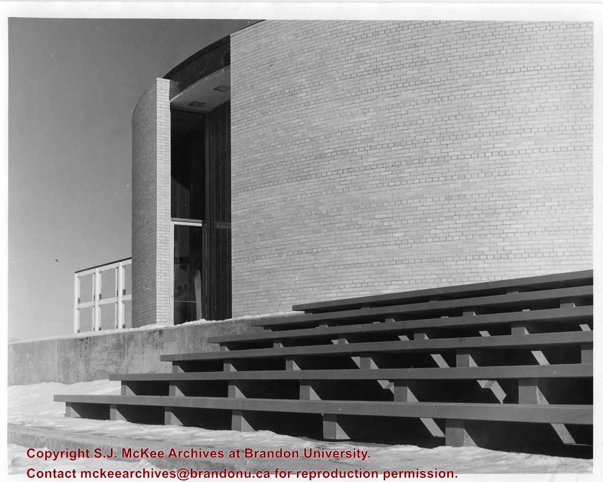
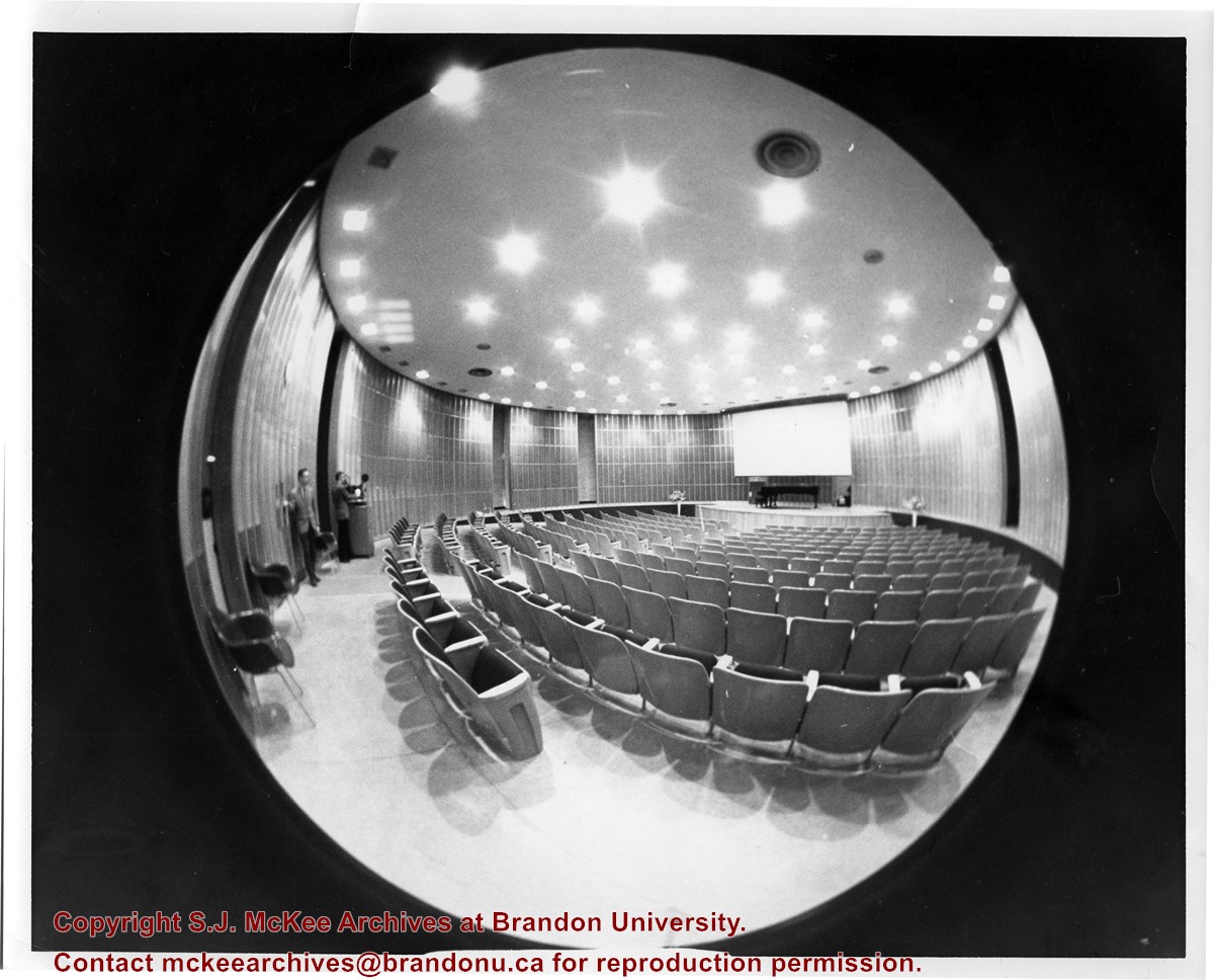
Photograph is looking west and shows where the J.R.C. Evans Lecture Theatre meets the link that joined it to the A.E. McKenzie Building. Photograph was taken in winter.
Images
Show Less

J.R.C. Evans Lecture Theatre interior

http://archives.brandonu.ca/en/permalink/descriptions881
Part Of
Brandon University Photograph collection
Description Level
Item
GMD
graphic
Date Range
[196-]
Part Of
Brandon University Photograph collection
Description Level
Item
Series Number
2.4
Item Number
BUPC 2.4.43
GMD
graphic
Date Range
[196-]
Physical Description
8" x 10" (b/w)
Scope and Content
Photograph was taken from the back right hand side of the J.R.C. Evans Lecture Theatre and is a bird's eye view of the interior of the building.
Images
Show Less

Library extension construction

http://archives.brandonu.ca/en/permalink/descriptions926
Part Of
Brandon University Photograph collection
Description Level
Item
GMD
graphic
Date Range
c. 1992
Part Of
Brandon University Photograph collection
Description Level
Item
Series Number
2.4
Item Number
BUPC 2.4.17
GMD
graphic
Date Range
c. 1992
Physical Description
3.5" x 5" (b/w)
Scope and Content
Photograph is looking east from 20th Street. It shows workers laying pipe during Phase I: Site preparation for the Library extension.
Images
Show Less

Library extension construction

http://archives.brandonu.ca/en/permalink/descriptions932
Part Of
Brandon University Photograph collection
Description Level
Item
GMD
graphic
Date Range
c. 1992
Part Of
Brandon University Photograph collection
Description Level
Item
Series Number
2.4
Item Number
BUPC 2.4.18
GMD
graphic
Date Range
c. 1992
Physical Description
3.5" x 5" (b/w)
Scope and Content
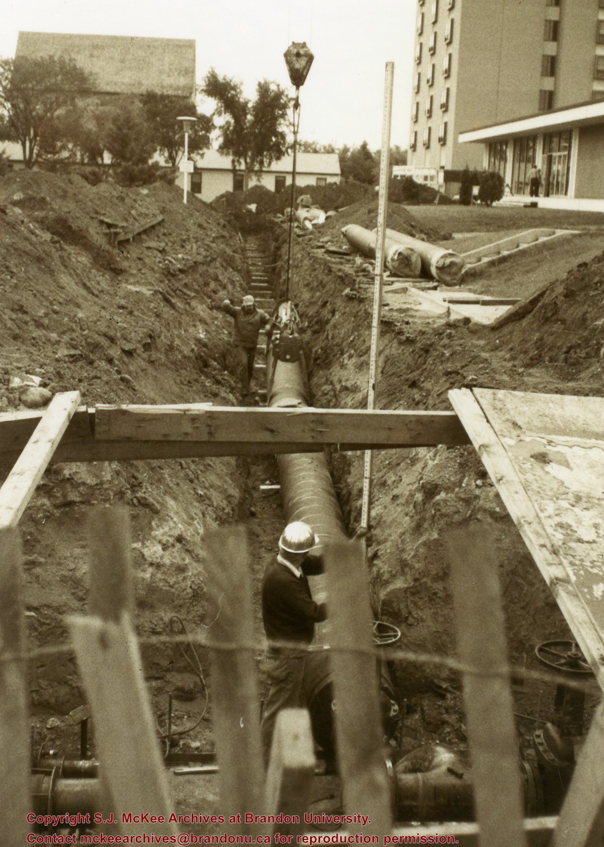
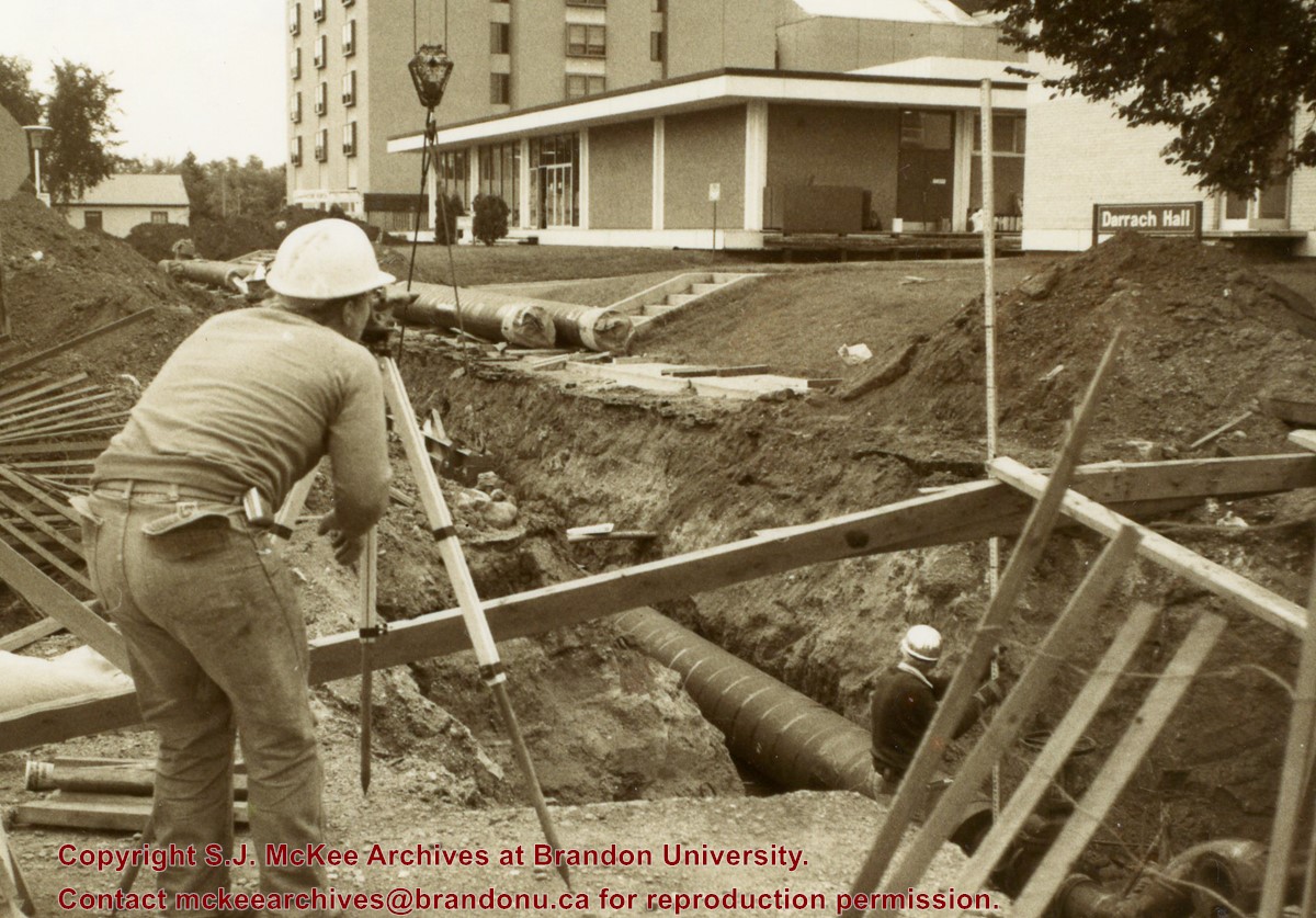
Photograph is looking southeast from 20th Street and shows the laying of pipes to the north of Darrach Hall and the Dining Hall as part of the Library extension. Photograph also shows a man surveying the site.
Images
Show Less

Dedication of the George T. Richardson Centre

http://archives.brandonu.ca/en/permalink/descriptions943
Part Of
Brandon University Photograph collection
Description Level
Item
GMD
graphic
Date Range
April 11, 1995
Part Of
Brandon University Photograph collection
Creator
Photographer: Sandy Black
Description Level
Item
Series Number
2.4
Item Number
BUPC 2.4.32
GMD
graphic
Date Range
April 11, 1995
Physical Description
4" x 6" (colour)
Scope and Content
George Richarson poses in front of the George T. Richardson Centre sign.
Images
Show Less

John R. Brodie Science Centre flower beds

http://archives.brandonu.ca/en/permalink/descriptions3019
Part Of
Brandon University Photograph collection
Description Level
Item
GMD
graphic
Date Range
May 1978
Part Of
Brandon University Photograph collection
Description Level
Item
Series Number
2.1
Item Number
BUPC 2.1.40
GMD
graphic
Date Range
May 1978
Physical Description
5" x 3.5"
Scope and Content
Photograph shows a number of the flower beds located on the north side of the John R. Brodie Science Centre.
Subject Access
campus photographs
Show Less
Part Of
Brandon University Photograph collection
Description Level
Item
GMD
graphic
Date Range
May 1978
Part Of
Brandon University Photograph collection
Description Level
Item
Series Number
2.1
Item Number
BUPC 2.1.41
GMD
graphic
Date Range
May 1978
Physical Description
5" x 3.5" (colour)
Scope and Content
Photograph shows a sign bearing a campus map. The sign was located at the north entrance to the driveway.
Subject Access
campus photographs
Images
Show Less

John R. Brodie Science Centre flower beds

http://archives.brandonu.ca/en/permalink/descriptions3026
Part Of
Brandon University Photograph collection
Description Level
Item
GMD
graphic
Date Range
May 1978
Part Of
Brandon University Photograph collection
Description Level
Item
Series Number
2.1
Item Number
BUPC 2.1.42
GMD
graphic
Date Range
May 1978
Physical Description
5" x 3.5" (colour)
Scope and Content
Photograph shows a number of flower beds located on the north side of the John R. Brodie Science Centre.
Subject Access
campus photographs
Images
Show Less

Stephen Adolph Magnacca fonds: Mayoral interests

http://archives.brandonu.ca/en/permalink/descriptions4789
Part Of
RG 5 Western Manitoba Manuscript Collection
Description Level
Sub-series
GMD
textual records
Date Range
1961-1969
Accession Number
5-1998
Part Of
RG 5 Western Manitoba Manuscript Collection
Description Level
Sub-series
Series Number
1
File Number
1-13
Accession Number
5-1998
GMD
textual records
Date Range
1961-1969
Physical Description
13 cm
History / Biographical
See fonds-level description of the Stephen Adolph Magnacca fonds.
Custodial History
See fonds-level description of the Stephen Adolph Magnacca fonds.
Scope and Content
Series consists of inaugural speeches, quarterly reports, documents about the closure of CFB Rivers, documents about Magnacca's proposal to build a new road to CFB Shilo, and documents about military and governmental celebrations in Brandon during the 1960s.
Storage Location
Stephen Adolph Magnacca fonds - Box 1
Storage Range
Stephen Adolph Magnacca fonds - Box 1
Arrangement
Box 1 1.1 Clipping: “City Getting Black Eye in Rural Areas?” [1963] 1.2 Notes from the mayor’s office 1964-5 1.3 Mayoral speeches 1964-5 1.4 Documents re: closure of CFB Rivers 1966-9 1.5 Papers of the Special Committee of the Future of CFB Rivers 1966-1968 1.6 Minutes of meetings re: clusure of CFB Rivers 1966 1.7 Clippings re: closure of CFB Rivers 1966-75 1.8 Correspondence re: closure of CFB Rivers 1963-9 1.9 Mayor’s office notes re: CFB Rivers [1966] 1.10 Documents re: proposal to build road to CFB Shilo 1962-9 1.11 Correspondence re: aircraft displays 1969 1.12 Documents re: Freedom of the City Ceremony 1967 1.13 Documents re: Squadron 408 1962
Show Less

Aerial view - Brandon University campus

http://archives.brandonu.ca/en/permalink/descriptions7989
Part Of
Brandon University Photograph collection
Description Level
Item
GMD
graphic
Date Range
c. 2000
Part Of
Brandon University Photograph collection
Creator
Photograph commissioned by Brandon University and taken by Yourview Aerial Scenics Ltd.
Description Level
Item
Series Number
2.1
Item Number
BUPC 2.1.55
GMD
graphic
Date Range
c. 2000
Physical Description
6" x 4" (colour)
Scope and Content
View is southwest from approximatley 16th Street between Princess and Rosser Avenues. Photograph shows the Brandon University campus, as well as surrounding residential blocks, including Flemming, J.R. Reid and Vincent Massey schools.
Subject Access
aerial photographs
campus photographs
campus buildings
Brandon streets
Images
Show Less

Aerial view - Brandon University campus

http://archives.brandonu.ca/en/permalink/descriptions7990
Part Of
Brandon University Photograph collection
Description Level
Item
GMD
graphic
Date Range
c. 2000
Part Of
Brandon University Photograph collection
Creator
Photograph commissioned by Brandon University and taken by Yourview Aerial Scenics Ltd.
Description Level
Item
Series Number
2.1
Item Number
BUPC 2.1.56
GMD
graphic
Date Range
c. 2000
Physical Description
6" x 4" (colour)
Scope and Content
View is west southwest from approximatley 16th Street between Princess and Lorne Avenues. Photograph shows the Brandon University campus, as well as surrounding residential blocks between 16th and 23rd Streets, Princess and Louise Avenues..
Subject Access
aerial photographs
campus photographs
campus buildings
Brandon streets
Images
Show Less

Aerial view - Brandon University campus

http://archives.brandonu.ca/en/permalink/descriptions7991
Part Of
Brandon University Photograph collection
Description Level
Item
GMD
graphic
Date Range
c. 2000
Part Of
Brandon University Photograph collection
Creator
Photograph commissioned by Brandon University and taken by Yourview Aerial Scenics Ltd.
Description Level
Item
Series Number
2.1
Item Number
BUPC 2.1.57
GMD
graphic
Date Range
c. 2000
Physical Description
6" x 4" (colour)
Scope and Content
View is west from approximatley 17th Street between Lorne and Louise Avenues. Photograph shows a portion of the Brandon University campus (excluding the Education Building and anything north of it), as well as surrounding residential blocks from approximatley 17th Street to 22nd Street.
Subject Access
aerial photographs
campus photographs
campus buildings
Brandon streets
Images
Show Less

Aerial view - Brandon University campus

http://archives.brandonu.ca/en/permalink/descriptions7992
Part Of
Brandon University Photograph collection
Description Level
Item
GMD
graphic
Date Range
c. 1990
Part Of
Brandon University Photograph collection
Description Level
Item
Series Number
2.1
Item Number
BUPC 2.1.58
GMD
graphic
Date Range
c. 1990
Physical Description
5" x 3.5" (colour)
Scope and Content
View is west northwest from approximatley 16th Street and Louise Avenue. Photograph shows the Brandon University campus, prior to the Library Extension, and a large portion of the city to the west of the campus.
Subject Access
aerial photographs
campus photographs
campus buildings
Brandon streets
Images
Show Less

Aerial view - Brandon University campus

http://archives.brandonu.ca/en/permalink/descriptions7993
Part Of
Brandon University Photograph collection
Description Level
Item
GMD
graphic
Date Range
c. 1990
Part Of
Brandon University Photograph collection
Description Level
Item
Series Number
2.1
Item Number
BUPC 2.1.59
GMD
graphic
Date Range
c. 1990
Physical Description
5" x 3.5" (colour)
Scope and Content
View is northwest from approximatley 16th Street and Louise Avenue. Photograph shows the Brandon University campus, prior to the Library Extension, and a large portion of the city to the west of the campus.
Subject Access
aerial photographs
campus photographs
campus buildings
Brandon streets
Show Less
Part Of
Brandon University Photograph collection
Description Level
Item
GMD
graphic
Date Range
c. 1985
Part Of
Brandon University Photograph collection
Description Level
Item
Series Number
2.1
Item Number
BUPC 2.1.60
GMD
graphic
Date Range
c. 1985
Physical Description
5" x 3.5" (colour)
Scope and Content
Photograph shows the removal of one of the houses formerly located on 20th Street between Louise and Princess Avenues. The houses on those blocks were removed to create parking lots for the University. A Fed Zavislak Ltd. Well Drilling & Trucking pickup truck is visible at the curb.
Subject Access
campus photographs
Brandon streets
Images
Show Less
Part Of
Brandon University Photograph collection
Description Level
Item
GMD
graphic
Date Range
c. 1985
Part Of
Brandon University Photograph collection
Description Level
Item
Series Number
2.1
Item Number
BUPC 2.1.61
GMD
graphic
Date Range
c. 1985
Physical Description
5" x 3.5" (colour)
Scope and Content
Photograph shows the removal of one of the houses formerly located on 20th Street between Louise and Princess Avenues. The houses on those blocks were removed to create parking lots for the University.
Subject Access
campus photographs
Brandon streets
Images
Show Less
Part Of
Brandon University Photograph collection
Description Level
Item
GMD
graphic
Date Range
May 12, 1992
Part Of
Brandon University Photograph collection
Description Level
Item
Series Number
2.1
Item Number
BUPC 2.1.62
GMD
graphic
Date Range
May 12, 1992
Physical Description
5.75" x 3.75" (colour)
Scope and Content
Photograph shows a backhoe digging a sewer hole near the sidewalk between the Brandon College Building and the Citizens' Science Building. The Knowles-Douglas Students' Union Centre, John R. Brodie Science Centre and a portion of the driveway are visible in the background.
Subject Access
campus photographs
campus buildings
campus construction
Images
Show Less

Brandon University campus

http://archives.brandonu.ca/en/permalink/descriptions7997
Part Of
Brandon University Photograph collection
Description Level
Item
GMD
graphic
Date Range
c. 1996
Part Of
Brandon University Photograph collection
Creator
Photographer: Sandy Black
Description Level
Item
Series Number
2.1
Item Number
BUPC 2.1.63
GMD
graphic
Date Range
c. 1996
Physical Description
6" x 4" (colour)
Scope and Content
View is northwest from the roof of the John R. Brodie Science Centre. Photograph shows the roof of the Knowles Douglas Students' Union Centre, the Citizens' Science Building, and the Brandon College Building and Clark Hall during renovation.
Subject Access
campus photographs
campus buildings
campus construction
Images
Show Less

Brandon University campus

http://archives.brandonu.ca/en/permalink/descriptions7998
Part Of
Brandon University Photograph collection
Description Level
Item
GMD
graphic
Date Range
c. 1993
Part Of
Brandon University Photograph collection
Description Level
Item
Series Number
2.1
Item Number
BUPC 2.1.64
GMD
graphic
Date Range
c. 1993
Physical Description
6" x 4" (colour)
Scope and Content
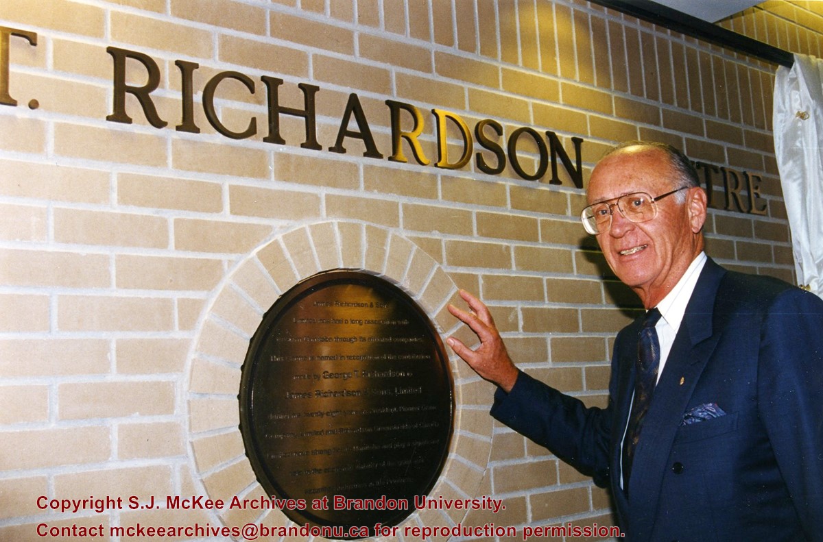
Photograph was taken from the roof of the Library and shows the walkway and flower bed on the southeast corner of the George T. Richardson Centre. The Physical Plant H-Hut is visible in the top right hand corner.
Subject Access
campus photographs
Images
Show Less

Brandon University campus

http://archives.brandonu.ca/en/permalink/descriptions7999
Part Of
Brandon University Photograph collection
Description Level
Item
GMD
graphic
Date Range
c. 1993
Part Of
Brandon University Photograph collection
Description Level
Item
Series Number
2.1
Item Number
BUPC 2.1.65
GMD
graphic
Date Range
c. 1993
Physical Description
4" x 6" (colour)
Scope and Content
View is southwest from the roof of the George T. Richardson Centre. Photograph shows the curved glass wall of the John E. Robbins Library, the walkway between the Library and the Dining Hall, the Dining Hall and Darrach Hall.
Subject Access
campus photographs
campus buildings
Images
Show Less

125 records – page 3 of 7.